HOME | BOOSTER | CEMETERIES | EDUCATION | GHOST TOWNS | HEADSTONE
MINOTTO | PICTURES | ROADS | JACK SWILLING | TEN DAY TRAMPS
American
Pioneer & Cemetery
Research Project
Internet
Presentation
Version
052409-2
SUPPORT
APCRP
YUCCA
CEMETERY
By Kathy Block, APCRP Historian
All
Photographs by: Kathy and Ed Block
The unincorporated
settlement of Yucca, Arizona was probably named after the yucca, a spiny desert
plant that has many species. The subspecies probably growing around the area is
Yucca schidigera, native to the Mojave-Colorado Desert. The roots
contain saponin and Native Americans used them for soap, especially shampoo,
and the fruits for food, and the leaf fibers in weaving fabrics. The
needle-sharp tips give the plant the name "Spanish bayonet." The
flowers are pollinated by a small night-flying moth which lays her eggs in the
plants' ovaries where the young feed on the developing seeds.
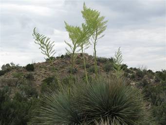 PHOTO LEFT: YUCCA plant with stalks,
too early to bloom.
PHOTO LEFT: YUCCA plant with stalks,
too early to bloom.
This now
almost deserted town, described in various Internet web pages as a "true
jerkwater town" and a "Route 66 Stepchild", and dismissed in a
Route 66 guidebook by Richard and Sherry Magnum, Route 66 across Arizona as
"Today there is nothing worthwhile to see of Route 66 while driving I-40
west of Kingman. So the 1952 alignment is seldom mentioned today." There
are only a few businesses left on the west side of I-40, including a seedy bar
called "Honolulu Club", E.F. Blanchard Spur Maker, a post office, a
gas station, a struggling cafe/general store, and real estate office. The
population, housed in mostly ramshackle homes and trailers, numbered 282 in
2000. Some income/business is provided
by personnel from the nearby historic Yucca Proving Ground.
The Yucca
Proving Ground, formerly owned by Ford, was purchased by Chrysler in November
2007 for $34.9 million. (Unknown status, due to Chrysler's
problems.) The land use began as the Yucca Army Airfield during World
War II for training pilots from the US Army Air Corps, originally using 2,284
acres of land, expanded to 4,000 acres by Ford in 1952. The Airfield gained
notoriety when a B-25 on a flight from Las Vegas to Yuma crashed into the
Mohave Mountains 25 miles SW of Yucca on July 10, 1945. All five crew members
died. Due to the remote location and steep terrain, their remains were not
recovered until Aug.3, 1945. The pilot was apparently confused by thunderstorms
and wind and veered off a safe course over the Colorado River. The plane hit
the mountains, corkscrewed and crashed. Pieces of the plane can still be seen
today near a peak called Crossman Peak. (The author can see this mountain from
their front yard.)
Yucca
began in the 1880s as an order office and water fill station for the Atlantic
and Pacific Railroad (affiliated with the Atchison, Topeka and Santa Fe
Railways). It was part of a rail line commissioned by Congress spanning from
St. Louis, Missouri to Needles, California. This rail line is a major freight
corridor to Southern California. In fact, the cemetery is fronted by the
railroad tracks to the west, and a large freight train roared by while we were
there! The Santa Fe railroad completed a land exchange of 70,000 acres with the
U.S. Government in 1997 just southwest of Yucca, and this land was subdivided
by the railroad into 40-acre parcels and offered to the general public as Stage Coach Trails development. The parcels are mainly being
purchased by individuals for residential use or long term investment. Other
smaller developments opened just north of Yucca in 2006. These developments may
eventually spur business growth in the area. Two major attractions are the
Stagecoach Trails Guest Ranch to the east and the "Golf Ball House"
to the northeast at Alamo Lake Road exit. A website with photos of Yucca's current
appearance is: TexasEscapes.com.
The route
west of Kingman was disputed even as the original alignment for Route 66 was
being selected in the 1920s. Oatman competed with
Yucca for the bypass route and temporarily won an alignment which didn't last
for the duration of Route 66. In 1952 when Oatman's
economic power had declined, the Yucca bypass was opened. This aided Yucca's
growth for twenty years and a classic motel, a truck stop, and other businesses
created jobs and Yucca's future looked bright. BUT, in the early 1970's,
Interstate 40 replaced the section of freeway of Route 66 going thru Yucca, and
bisected and bypassed the town. The motels and truck stop, located on the east
side of the freeway, went out of business as people used facilities in Kingman,
Arizona, 35 miles NE, and Needles, California, 38 miles west.
The Yucca
Cemetery reflects the bleak appearance of the area. It is located on First
Street between Sixth and Fifth Streets. To access, take Proving Grounds Road
exit off I-40, head west, and either take Frontage Street, which parallels the
freeway, for one block, and turn right (west) on Sixth Street and Frontage, go
four blocks to the street paralleling the railroad tracks, or go straight west
when exit, go four blocks, and turn left on a dirt track for a block. The
cemetery is on the east side of First Street, facing the railroad tracks. (GPS
Coordinates are: N34* 52.567, W114* 09.132. Accurate within
10 feet. Elevation 1,824 feet.)
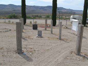
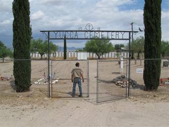 The
cemetery is entered thru a gate under an elaborate ironwork arch that reads:
" 1918: Yucca Cemetery, To the right of the gate
is a sign that says: "This is not an endowed cemetery." Once
entered, the stark raked gravels, the many unknowns gravesites, and headstones
mostly arrayed around the perimeter of a fence greet you.
The
cemetery is entered thru a gate under an elaborate ironwork arch that reads:
" 1918: Yucca Cemetery, To the right of the gate
is a sign that says: "This is not an endowed cemetery." Once
entered, the stark raked gravels, the many unknowns gravesites, and headstones
mostly arrayed around the perimeter of a fence greet you.
There is
a signboard explaining that a group was formed in 2002 to restore and protect
this cemetery, and asks for funding help, displays "memorials" and
"gift pledges" on plaques, etc .
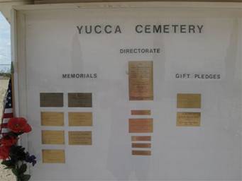
There are
not many plaques. Prior to this time, the cemetery was in danger of
disappearing altogether! It had been
used for burials since the 1880s when the railroad was establishing their
facilities, but wasn't officially designated a cemetery until 1918. It was
recorded as a burial location then, and had been protected from private acquisition
until about 1969-1970 when there was a statewide reassessment program regarding
real property in Arizona. The tax lots appeared on the delinquent tax rolls and
were to be offered for sale! A group of interested persons, many of whom had
family members buried in Yucca Cemetery, got advice and cooperation from then
Judge of the Superior Court, the Honorable Frank X. Gordon, Jr., and formed the
Yucca Cemetery Association. Thus, any attempt to seize and sell the lots was legally
and effectively avoided. Note: This threat to cemeteries continues today, as in
a case near Phoenix, where a couple bought a parcel of land containing, unknown
to them, a historic Hispanic cemetery!
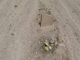
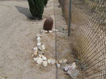 There are
approximately 36 burials identified in this cemetery, but also many unmarked burials
with no headstones. Early records were apparently spotty and incomplete, and
some records have been lost. The earliest identified burial was Luie Jauncie, birthdate
unknown, died October 1910. The last burials seem to be in 1999. There are many
babies in unmarked graves. When a fence was erected around the cemetery by the
Association, one unknown grave was bisected!
There are
approximately 36 burials identified in this cemetery, but also many unmarked burials
with no headstones. Early records were apparently spotty and incomplete, and
some records have been lost. The earliest identified burial was Luie Jauncie, birthdate
unknown, died October 1910. The last burials seem to be in 1999. There are many
babies in unmarked graves. When a fence was erected around the cemetery by the
Association, one unknown grave was bisected!
|
|
|
Photo’s
5 and 6
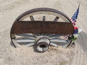
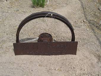
Some of
the headstones are rather unique, one is a wagon wheel and another is a rim
from a vehicle wheel! (Photos 5 and 6).
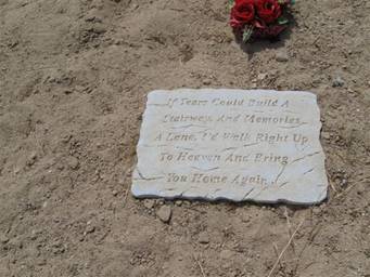
The most
sentimental plaque, pictured on left, near headstone for a couple, is pictured
on left. One burial, a Mr. Thompson, dates of birth and death unknown, was
supposedly killed at either the San Francisco mine or the Cedar Mine. (See
information on Cedar/Cedarville on www.apcrp.org
website.)
|
|
|
Photo’s
8 and 9
American
Pioneer & Cemetery
Research Project
Internet
Presentation
Version
052409-2
WebMaster: Neal Du Shane
Copyright © 2009 Neal Du Shane
All rights reserved. Information contained within this
website may be used
for personal family history purposes, but not for financial profit of any kind.
All contents of this website are willed to the American Pioneer & Cemetery
Research Project (APCRP).
HOME | BOOSTER | CEMETERIES | EDUCATION | GHOST TOWNS | HEADSTONE
MINOTTO | PICTURES | ROADS | JACK SWILLING | TEN DAY TRAMPS