HOME | BOOSTER | CEMETERIES | EDUCATION
| GHOST TOWNS
|
HEADSTONE
MINOTTO
|
PICTURES
| ROADS
| JACK SWILLING
|
TEN DAY TRAMPS
Internet Presentation
Version 062708

An Enduring Mystery
By: Allan Hall – APCRP Coordinator
At approximately 8:00 a.m. on the morning of November 5th,
1871, a stagecoach carrying seven passengers and driver was ambushed eight
miles west of Wickenburg while en-route to Culling’s
Well, Ehrenburg and
Evidence, (some of which was circumstantial and conflicted), eventually led the Territorial Army to attribute the attack to a band of “Apache-Mohave” Indians from the Date Creek Reservation. This group, which would actually have been members of the Yavapai tribe, numbered at least thirteen; but may have been comprised of thirty or more. Yet, although the attack and its aftermath were investigated and heavily reported, many of the details pertaining to the ambush and its after-events are an enduring mystery. Many of the news articles were misinformed or speculative; written by people who had no direct connection with the events of November 5th but which served to inflame public sentiment against Native Americans. [Reference 2]
The “Wickenburg Massacre” has long been a cornerstone in the history and legend of our town, yet very few people know where the ambush actually occurred. [Reference 3]
The Route from Wickenburg to the Massacre
According to historical accounts the stagecoach arrived at
Wickenburg from
The “roads” in the 1870 period of territorial
Such was the case for the route from Wickenburg to Culling’s Well. The
stage coach road led west through (or alongside) Sol’s
Stage coaches of that era were pulled by a team of four horses and could travel approximately eight miles per hour. They would have arrived at their waypoint destination at Culling’s Well, (a distance of 36 miles), no later than noon of that day. Assuming that the coach left Wickenburg at the scheduled time, it would have arrived at the massacre site at about 8:00 a.m., as reported by Kruger and Sheppard.
The Ambush Site
Approximately 200 yards southeast of the ambush site, the stage coach road emerges from the wash onto a hard pack flat area and follows a path on the southwest side of the wash. At this point the wash begins to “fragment” into several narrow fingers, which would have made passage more difficult for the coach. So, at this location the stage coach would have been between a hillside (to the west and south) and a narrow finger of the wash to the east and north (right side of the stage coach). In Figure 1 the road extends from right to left, where it approaches the ambush site. The lower finger of the wash appears in the middle right of the photo before it drops from view because of the steep bank.
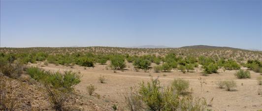
Figure 1:
The wash bank measures about three feet in height as it nears the site of the ambush. See Figure 2. In this photo the stage road is now to the right (south and west) of the bank. The trail is partially visible in the upper right corner, as shown below.
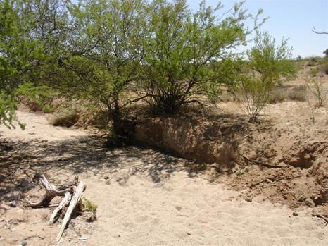
Figure 2: The
If this is indeed near the site of the attack, it would have been very easy for members of an ambush party to conceal themselves along the edge of this bank until the coach, traveling at a slow speed, would have reached a minimum distance from the bank. In fact, the trail comes to within fifteen feet of the wash just a few yards west (right) of the photo. It is possible that some of the attackers could have been positioned along this bank and fired into the rear of the stage coach from behind. It should be noted that Captain Meinhold, who was dispatched to the scene from the army post at Camp Date Creek, reported finding several moccasin tracks in the wash near the ambush. However, most (if not all) of the wounds sustained in the initial attack suggest that the ambush party was positioned on high ground to the south of the trail. There were seventeen bullet entry points in the cabin of the coach – none of which were fired from the north (right) side of the coach. Physical evidence at the ambush site and statements by Kruger and Sheppard indicate that the primary point of attack came from the south. The two wounded survivors made their escape from the coach on the north side into the wash shown above and in Figure 3, below.
Burial
Site: History or
Legend?
Based upon a letter that Kruger wrote for Loring’s father, five of the men who died at the scene were reportedly buried in Wickenburg on November 6th, three hours after a hastily called inquest. The sixth man, William Salmon, was not discovered until the morning of the 6th and was reportedly buried in a “deep cut in the hillside.” [Reference 5] Later reports claim that his remains were exhumed from the hillside and laid next to the other five men several weeks or months later. For unexplained reasons, the local graves of these men were reportedly “disturbed” in 1949 and then disappeared from local records.
The original location of their presumed graves in Wickenburg
is a matter of some conjecture, but would likely have been either the
In the years that followed, the remains were said to have
been exhumed and re-interred at least twice to new locations. The last re-interment may have returned the
remains to the original site of the ambush – at least according to legend. Unfortunately, any records that could explain
the reasons for moving these burials are now lost in time. [Reference 6]
An Aerial View of the Scene
One of the great benefits of aerial photographs is they help provide a perspective that is difficult, if not impossible, to gain from standing on the ground. Modern satellite photos (such as Google Earth and Microsoft Virtual Earth) generally provide good clarity, but I prefer older aerial photos because they reveal old trails that predate modern era off-road activity. See Figure 3.
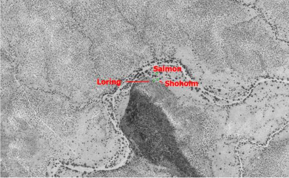
Figure 3: Aerial View
In this view it is easy to see the meandering course of the wash as it flows from lower left (upstream) to the right (downstream, toward Sol’s Wash and Wickenburg). You can also see the multiple fingers of the wash on the east, north and west sides of the hill. Three graves are shown to provide physical context.
Physical Count &
Description of
Grave 1: Figure 4 shows a partial view of graves at the apparent site of the ambush. The rock pile with the wood cross is believed to be Frederick Loring, who was riding on top of the stage coach with the driver, “Dutch” John Lance, and another passenger, Charles Adams. There are additional graves to the left, also uphill beyond the cross, and also behind the photo.
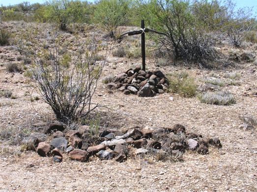
Figure 4:
As Figure 5 (below) shows, the right grave is considerably shorter than the rock mound would suggest. The left-most grave actually extends beyond the edge of the rock mound and is several inches longer than the grave to the right. The scattering of the rocks beyond the actual grave dimension is probably the result of disturbance by cattle, horses, or other foot traffic over the decades.
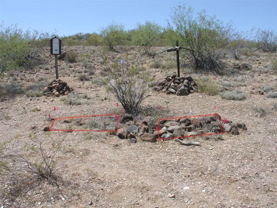
Figure 5: Grave Locations Identified
Grave 4: About twelve feet to the left of the foreground graves you will find another unidentified male burial. See Figure 6. This is a single mounded grave, similar in appearance to the two foreground graves shown in Figures 4 and 5. In this case, however, the grave mass is actually longer than the rock mound.
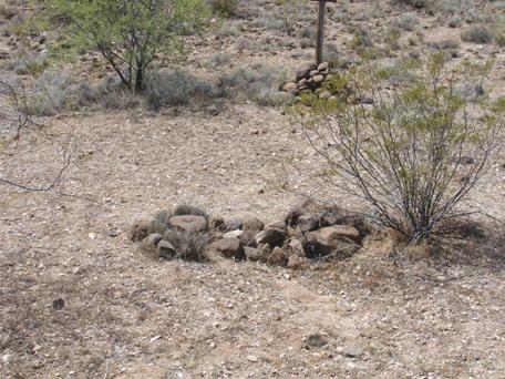
Figure 6: Single Male Mounded Grave
The upright post at the top of the photo is not Loring’s cross – it is the marker for the book written by R. Michael Wilson, originally titled “Drenched in Blood, Rigid in Death.” This title and publication came out in 2000. The newer book title was published in 2008. [See again Reference 1]
Grave 5: Systematic dowsing between the foreground
grave (above) and the
Grave 6: The partially reconstructed grave shown in Figure 7 is, I believe, that of Frederick Shoholm. It is located between the stage coach road and the bank of the wash. (See also Figure 3). Based upon the dimensions of the grave mass, Shoholm must have been a short, stocky man. Measurements indicate a height of 4 feet 10 inches, with an upper torso width of 29.5 inches.
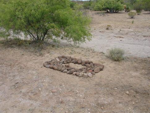
Figure 7: Shoholm's Grave
This grave site had no outline, no mounding or other form of
identification when survey work began.
The rocks shown in this photo were set in place by me and were collected
from hillside areas away from the Massacre Site. This grave has also been corner pinned with
10” spikes to permanently establish dimensions.
[Note 7]
According to
Nevertheless, the position of this grave (between the road and the wash) is in a location that has no surface rock. The lava-pumice rocks shown in previous photos were collected (at an earlier time) from the hillside, which is generally covered with these rocks. The absence of rocky material at Shoholm’s grave may simply be due to its proximity to the wash and flood plain. Pumice rocks are relatively light weight and could easily be swept away in heavy runoff conditions. Notice also that the “island” beyond the wash is also barren of rocky material.
Before leaving Figure 7, notice the area beyond the small finger of the wash and focus on the large Acacia tree in the upper right. Directly in front of this tree is William Salmon’s grave. See Figure 8.
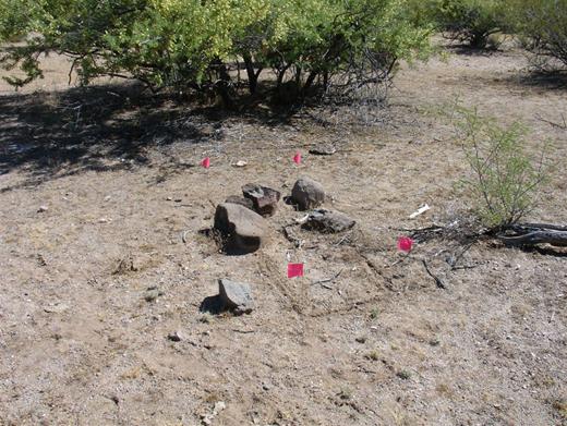
Figure 8: Salmon's Grave
Grave 7: The most distant grave from “Loring’s cross” is roughly 120 feet to the northeast and is believed to be William George Salmon. The Wickenburg pursuit posse and subsequent army reports clearly indicate that he was killed very near to this location. He may have been buried (or eventually re-interred) at this spot. More on that subject later.
According to
As indicated in previous statements and photos, this grave is located between two fingers of the wash. Figures 7 and 8 clearly show that this area is essentially barren of native rocks due to the force of periodic flooding. The six or seven rocks shown in Figure 8 would be a “red flag” for anyone conducting grave research in this type of terrain. Their proximity to the reported location of Salmon’s death was a significant aid in locating the grave site.
The survey of the grave shows a body mass that is 6 feet 0 inches in length with an upper torso width of 29 inches. Corner pins have been placed on the perimeter of this grave to mark dimensions for future reference and research.
The rocks shown in Figure 8 do not bear the same characteristics as those on the hillside next to Loring’s cross. In fact, they have a more dense mass and more closely resemble rocks in the northern finger of the wash. It is possible that they have survived the decades of flooding in this “island” area simply because they are heavier. In any case, it would seem that several rocks were removed from the northern wash to establish a crude marking for this grave.
We have thus far accounted for seven graves. Three additional male graves have been identified on the hillside, above Loring’s cross.
Three
Three more graves have been located beyond Loring’s cross, above and west on the hillside. There are no grave markers, crosses or headstones, but two of them have an easily distinguishable rectangular rock outline. The three graves are placed in an arc. That is, one grave is to the southwest, one is almost due west, and the third is located to the northwest of Loring’s cross. I cannot help but think that this is a purposeful arrangement. If this is the case, then it is tempting to think they are related to the massacre in some way. Unfortunately, all three graves remain unidentified at this time.
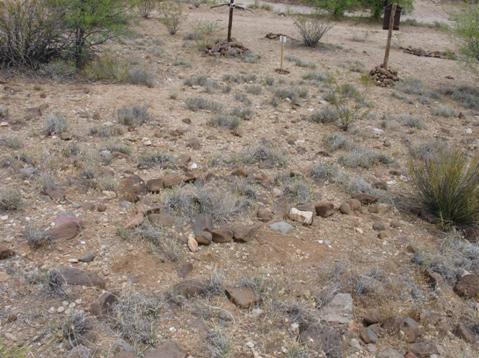
Figure 9: Grave Above and Southwest of Loring's Cross
Grave #8 – Southwest of Loring’s Cross: The grave in the center of Figure 9 is a “reverse angle” photo facing northeast toward Loring’s cross. It is an adult male, measuring only 4 feet 9 inches in length. The lower end of the grave is precisely thirty feet from Loring (top center) and the head is at the west (left). Before this photo was taken I moved two rocks to help straighten the alignment but otherwise, what you see in the photo is the original configuration. At this writing the grave remains unidentified. The stage coach road and lower finger of the wash are visible beyond Loring’s cross in the upper portion of the photo.
Grave #9 - West of Loring’s Cross:
This unidentified male grave seems to have suffered the most from the
scattering (or removal) of rocks. The
grave outline was indistinct before the photo in Figure
10 was taken. It is possible
that material was removed from the site to build up the rock
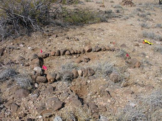
Figure 10: West Grave, Uphill from Loring's
Cross
Grave #10 – Northwest
of Loring’s Cross:
The photo in Figure 11 shows the
third uphill grave. It is approximately
twenty-three feet from the cross and is also oriented on an east-west axis;
with the head position located in the foreground. Clearly visible below is Loring’s
cross, the two unidentified male graves and the single male grave (directly
beyond the cross post). Also visible is
the stage coach trail and the lower finger of the wash. The grave shown in the foreground is
untouched, except for temporary flagging pins that were placed to show the
actual grave dimensions.
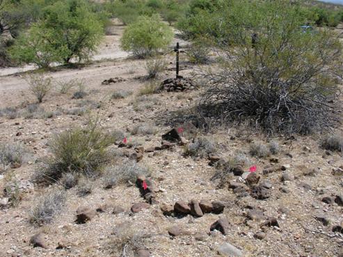
Figure 11: Male Grave Above and Northwest of Loring's Cross
Assessment
When you compare the historical account of the massacre to
the number of graves at this location there is a major problem - there are
simply too many. No less than ten graves
have been identified; but six men were killed at the scene, and then reportedly
taken from the site for burial in Wickenburg (Salmon being the last). Although Mollie Sheppard eventually died from
her wounds, she was last known to be in
To compound the problem, there are six to eight additional graves located south-southeast of this site at a distance ranging from fifty to 150 yards from Loring’s cross. Without a better historical context, the general area is an exceedingly unusual location for eighteen graves. There is no physical evidence that a settlement was ever established here before or after the ambush. Stage coach and freight wagon robberies, which occurred with depressing regularity during the gold rush days, may account for some, or all, of the surplus. However, there are no known records that establish killings in this area of the wash other than the November 5th ambush. As R. Michael Wilson noted in his book, the freight teamsters were definitely wary of this area before November 5th, 1871
More Problems with the
There is a second problem with the view in Figure 4 and related photos. This site is indeed located on a hillside, but the eastern slope of the hill is very gentle at this point and (assuming no significant changes in vegetation since 1871) would have offered little or no concealment for a large group intent on an ambush. Newspaper reports and testimony suggested the ambush occurred at a distance as short as six to fifteen feet. That is virtually point blank range for Henry and Spencer rifles. Even with improvised cover, I have great difficulty accepting that thirteen (and especially thirty) members of an ambush party could have concealed themselves at this location without being noticed before the final moment. Remember, the drive and two passengers were on top of the stage coach with a fill field of view that was denied to the inside passengers. It is possible, perhaps even likely, that the ambush occurred another twenty to thirty yards west of the location shown in Figure 11, where the hillside is more steep and closer to the stage coach trail.
Take a moment to reexamine Figures 9-11 and notice
the type of vegetation in these photos.
The native creosote bushes are widely dispersed and the clumps of grass
that grow in the area do not measure more than four or five inches in height. The construction of improvised concealment
for an ambush party, particularly in the area of the graves site, would have
required considerable preparation.
According to the time line in
A Mystery Wrapped Inside an Enigma?
There is no doubt that this site has been established as the massacre memorial by earlier generations of Wickenburg residents. Furthermore, the route, distance, the hillside and wash match the descriptions provided in historical accounts to within a distance of thirty yards. That is a trivial discrepancy and only acquires hypothetical significance when you examine the hillside and wash from a higher elevation.
Within a radius of forty feet from “Loring’s cross” there are clearly distinguishable graves – some with rock mounds, others with easily identifiable rock outlines. There is also a grave very near the spot where Salmon was reportedly killed. They all appear to be randomly placed. In other words, there is no apparent organization; there are no neat rows or alignment that you would expect at a “traditional” cemetery. At ground level this appears to be a chaotic burial site. And there lies the rub.
If the six male victims were first buried (side by side) in a Wickenburg cemetery or in Henry Wickenburg’s private graveyard, and then eventually re-interred at the massacre site after a passage of 78 years, why would these present graves have the appearance of random placement? Why would Salmon, the sixth victim, now be buried 120 feet from the location of Loring and the others if he was previously buried next to them in Wickenburg?
Another question deals with the apparent dimensions of all ten graves. If the remains of the six victims were re-interred at the Massacre Site after 78 years, they would most likely have been buried in small boxes that would measure approximately two to three feet in length. Instead, all of the graves have dimensions which indicate normal (that is, “undisturbed”) body length.
Finally, there are accounts that the six men were buried “in the southeast corner of the private graveyard set aside by Henry Wickenburg.” In the letter Kruger wrote for Loring’s father, he claims that he witnessed their burial. Unfortunately, the private graveyard of Henry Wickenburg did not come into existence until 1905 – thirty-four years after the massacre. That is a particularly tough pill to swallow.
A partial answer to this mystery is revealed in two newspaper articles published in the March, 1948 editions of the Wickenburg Sun. In the March 12, 1948 edition, the Sun printed an announcement of a trek to the Massacre Site, sponsored by the Wickenburg Saddle Club. It specifically advertises a “…trek to the graves of the five men killed by Indians in the Wickenburg Massacre…” The follow up article on March 19th reported that “a marker and plaque were erected at the head of the mass graves” to name the victims and commemorate the site. Sadly, this marker and plaque no longer exist. Nevertheless, these two articles give evidence that at least five of the six men were buried at the massacre site on (or before) 1948 and that five of the six names were known to local residents and historians. [See Reference 8 for a complete transcription of the March 19th article]
It is possible that locals of this time did not know about the location of Salmon’s grave on the “island,” or about Shoholm’s grave, which was entirely unmarked. In either case, these articles confirm that at least five of the six men were known to be buried at the Massacre site. It is truly a shame that the 1948 plaque no longer exists. It would greatly simplify modern day research.
Three of the six male graves have now been identified: Frederick Loring, William Salmon and Frederick Shoholm. Based upon the ‘Wickenburg Sun’ articles, there is every reason to believe that Charles Adams, Peter Hamel and “Dutch” John Lance are also buried at the Massacre Site.
Without further evidence I can provide no concrete answers and I am unwilling to yield to simple speculation. I hope there are still long time residents among us who have first hand knowledge (or verifiable documentation) that can shed more light on these graves, as well as the circumstances surrounding the reported “disturbance” of the Wickenburg graves in 1949 and the events of the March 1948 visitation.
Closing Thoughts
The Wickenburg Massacre was an important event, both at the
national and territorial levels in 1871.
The ambush may have been motivated by a desire for vengeance against
earlier killings of Indians by
Between September, 1872 and March, 1873 more than 120 Yavapai were killed in army campaigns. The Yavapai tribes surrendered in April, 1873 and were forced off their ancestral lands during the winter of 1875. 1,426 Indians (a mixture of Tonto Apache, Yavapai and Hualapai, were marched to the San Carlos Reservation, but 105 died along the way. When you visit the Wickenburg Massacre, you might do well to think about the full context of this site – what transpired here, and what followed afterward.
Many local residents of the time believed the attack was carried out by Anglo or Mexicans bandits and not Yavapai Indians. Local descendants of that era grew up with an understanding that the victims were buried where they died and were never transported to Wickenburg. These strongly held beliefs persist to the present time.
If you are interested in the history and legend of
Wickenburg, - particularly if you are interested in preservation - then you
should visit the massacre site. By any
standard of definition it qualifies as a derelict pioneer cemetery. It is not maintained. The only thing that protects it today is its
location and obscurity. It is, however,
on
Finally, I hope to write an update to this posting in the fall (2008) time frame to document the remaining survey work and research that will (hopefully) be completed by that time.
Unfinished Work
1. I am confident that Loring, Salmon and Shoholm are buried at this site; but that still leaves six male graves and one female grave unidentified. With additional research we may yet be able to learn if any of the remaining graves belong to Charles Adams, Peter Hamel and/or “Dutch” John Lance. That will go a long way to solving an enduring mystery. Hopefully, we will eventually be able to identify the female and remaining three male graves. Who were they? When were they buried here?
2. Reconstruction of the grave for Shoholm is not complete, but has progressed to a point that it will probably withstand minor runoff from monsoon storms. Shoholm’s grave is within ten feet of the wash bank and will almost certainly suffer future damage if it is not given more protection.
3. Salmon’s grave – located in the “island” between two fingers of the wash – is particularly vulnerable to flash flooding. Only six or seven rocks remained at this site when it was identified. It needs to be reconstructed and protected.
4. Additional survey work is required for the two male graves below (east) of Loring’s Cross in Figure 5. The rock mound has clearly been disturbed and reconstruction is needed. The left-most of these graves needs to be completely reconstructed.
5. The single male grave (Figure 6) is fairly safe from flooding but it needs to be repaired. It is the only grave that shows evidence of surface collapse and the rock mound is shorter than the grave mass.
6. The location and dimensions of the female grave need to be firmly established so that it can be properly marked.
7. The three uphill male graves need to be repaired and, if possible, mounded for long term protection. As it stands today, rock outlines around these graves have been scattered.
8. The point of ambush is not well established. I believe it occurred at a point more closely aligned with the northern end of the hillside, where it would have been closer to the wash. I also believe that the increased steepness at this point would have favored the ambush party. This issue may not ever be resolved, but shared observations may help clarify the question.
9. There is a remote possibility that some of the bullet
casings may yet remain at the ambush site.
How to Get There
Getting to the massacre site is not particularly difficult, but it does require a bit of patience.
The turnoff point is six miles west of the intersection of
Exit from the highway to your right onto a dirt road. It will lead you to a gate with a sign that says you are entering State Trust land. The sign also states that a valid lease or permit is required for entry. This basically means (1) you are grazing cattle on leased land or (2) that you have a valid hunting license or some other type of permit. Use your own judgment about entering this area without a permit.
The distance from US-60 to the massacre site is 6.6 miles along an unimproved dirt road. See the map in Figure 12.
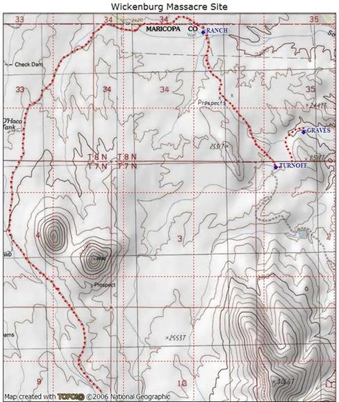
Figure 12: Route to Massacre Site
The road will take you in a northerly direction before turning east, where it leads to an abandoned ranch and corral. Turn right at the ranch and pass between the fence posts to the left of the water tanks. Continue in a southeasterly direction until you arrive at a large wash. Turn left and follow the wash until you arrive at the massacre site.
High-clearance vehicles are required and 4WD is definitely recommended. There are numerous erosion channels that cross-cut the dirt road between US-60 and the old ranch house. After turning into the wash, you will be in deep sand the remainder of the way.
GPS coordinates (WGS84)
1. Turnoff from US-60: N 33o 56’ 56.2” by W 112 o 52’ 35.0”
2. Turnoff from the dirt road into the wash: N 33 o 59’09.3” by W 112 o 51’ 24.9”
3. Loring’s Cross at Massacre site: N 33 o 59’ 21’5” by W 112 o 51’ 13.1”
Before You Go
1. Summer monsoon storms and winter rains can produce considerable runoff in this area. After heavy rains you may encounter areas of standing water that can persist for a week or more. Traversing these areas while they are muddy will hasten the degradation of the trail.
2. Always take an ample supply of water.
3. Make certain that someone knows specifically where you are going and when you plan to return.
4. Don’t count on your cell phone to get you out of trouble. This site is in the bottom of a wash. Cell phone signals are blocked by steep hillsides to the east, south and west.
5. Be alert to snakes between March and October.
Finally, stay on the trails – there are no shortcuts. And… pack out your litter.
Notes and References:
1. “Massacre
at Wickenburg –
2. Even
modern writers who attempt to recreate this important piece of our history
acknowledge that some of their conclusions are conjecture rather than
indisputable fact; including some of the findings made by the author in Reference 1.
Even for serious and accomplished historians,
the ‘fog of time’ makes the Wickenburg Massacre an enduring mystery!
3. The
Wickenburg Massacre was frequently referred to as the “Loring
Massacre,” particularly in the eastern press.
Frederick Loring was a popular and respected
young journalist from
4. Mileage
is based upon GPS tracks from Sol’s
5. I have walked and photographed the entire eastern hillside below the site of the ambush for a distance of about 400 yards. There are four gullies, but only one of these (the one most distant from where Salmon died) could potentially qualify as a “deep cut in the hillside.” It has never been explained why Salmon would have been buried in an erosion gully when he could have been buried where he died.
6. The Wickenburg Historical Preservation Society maintains a long-held belief that the massacre victims were buried where they died. See also Reference #8 below.
7. I
have reconstructed grave outlines in pioneer cemeteries that were close to washes and found that my efforts were partially (or fully)
washed away after a heavy monsoon storm a month or two later. There is no permanency to our feeble efforts
when graves are located in a flood plain.
That is one reason why I place metal spikes at the grave corners in
derelict cemeteries. Galvanized nails
(10” or 12” in length) will survive the arid conditions in the
8. After this article was originally posted on the APCRP web
site,
The Wickenburg
(AZ) Sun
Saturday, March
19, 1948
Club Marks
Thirty-one horseback riders took part
in the first annual trek to the graves of the Wickenburg massacre victims,
sponsored by the Wickenburg Saddle Club last Sunday morning.
Assembling on Frontier Street at 11 o'clock,
the club's president, Al Barnes, led the group of horsemen to the grounds of
the Matthie Cattle company about a mile from the
graves where Cecil Kellogg and John Walker had prepared the kind of chuck wagon
meal which could well be called a "Gift of the Gods."
A number of automobile drivers, headed by Pioneer
resident J R Barnette, drove to the scene and joined
in the chuck wagon dinner. Some 60 people were served. Following the meal, a
history of the Wickenburg massacre, prepared by Ewald
A Stein, was read. Chuck Huerta, well known violinist from Chicago's radio
station WLS who has been visiting at Cactus Gardens Lodge, entertained with his
violin and Teddy and Barry McMillan played the mandolin and guitar.
After the program, the riders went to the
graves of the murdered men while a few others braved the rough terrain in the
Gerber jeep. A marker and plaque were erected at the head of the mass graves
and a ceremony was held with Alvin Rees officiating.
I am grateful for the generous consultation and contributions made by several APCRP members and fellow historians in the preparation of this article. Special thanks go to Neal Du Shane, Pat Ryland and Bonnie Helten.
An abbreviated version
of this article appeared on www.wickenburg-az.com June 21, 2008.
Internet Presentation
Version 062708
WebMaster: Neal Du Shane
Copyright ©2003-2008 Neal Du
Shane
All rights reserved. Information contained within this website may be
used
for personal family history purposes, but not for financial profit of any
kind.
All contents of this website are willed to the American Pioneer &
Cemetery Research Project (APCRP).
HOME | BOOSTER | CEMETERIES | EDUCATION
| GHOST TOWNS
|
HEADSTONE
MINOTTO
|
PICTURES
| ROADS
| JACK SWILLING
|
TEN DAY TRAMPS