HOME | BOOSTER | CEMETERIES | EDUCATION | GHOST TOWNS | HEADSTONE
MINOTTO | PICTURES | ROADS | JACK SWILLING | TEN DAY TRAMPS
American Pioneer
& Cemetery Research
Project
Internet Presentation
Version 020309


By:
Kevin Hart
White Hills, Arizona
January
24, 2009 - Leaving Phoenix at 4:00 AM, this turned out to be a long one day
adventure but well worth the effort.
From
Kingman it is roughly 40 miles to White Hills Road off of Route 93. The road is
paved, which surprised me. The topographical map has White Hills Road as a dirt
road. The road is paved all the way to the end which is approximately 10 miles.
After
reaching the general area of White Hills, I first turned left where the map has
a road going to the left, but there was a locked gate with a sign saying
private property no trespassing. The road also had a right turn but that went
to an operating mine with the same no trespassing sign; therefore, I was unable
to check out the cemetery that was supposed to be on that side of the White
Hills Road and believed to be the second of three possible Pioneer Cemeteries
in the White Hills community.
Taking
out my GPS and laptop computer which I took with me for the trip and using
Terrain Navigator, I was able to determine that my location was north of the
cemetery shown on the topographical map. I drove back down White Hills Road and
noticed a dirt road going off to the right, somewhat towards the cemetery. Taking
that road I came to a fork and took the left fork, which according
to Terrain Navigator, should pass just to the right
of the cemetery.
|
|
|
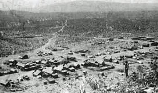
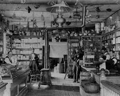
White Hills – Then and a few years
ago. No structures
remain today.
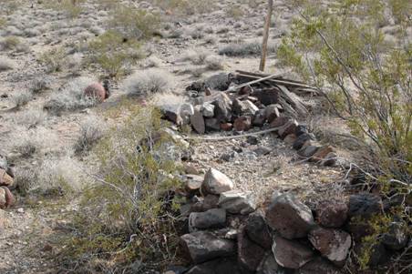
The
laptop indicated my location was to the right of the cemetery, but I could not
see anything that resembled a Pioneer Cemetery. I got out of my vehicle to
observe the terrain and look for landmarks as the
cemetery is not easily found at first glance. After walking about 50 feet east,
I noticed a post sticking up. I walked over to it and saw that it was the
cemetery and was pleasantly surprised at its condition. It was fenced with two rows of barbed wire and
had a number of graves outlined with rocks. At this time I observed a road that
came right up to the cemetery.
|
|
|
I
back tracked and found the road. The road into the cemetery could easily be
reached by a non 4-wheel drive vehicle. Once I reached the cemetery I climbed
up on my jeep to get a wide angle picture of it. I went inside the barbed wire
enclosure of the cemetery to look around and make a plan of what I wanted to
accomplish.
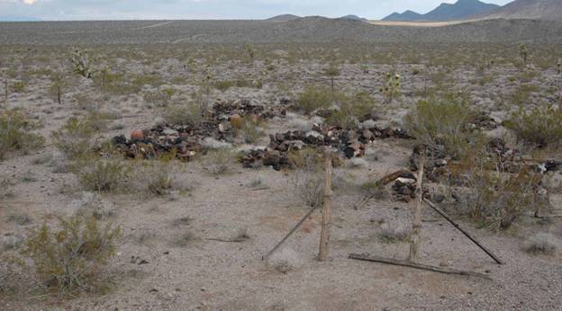
Photo courtesy: Kevin
Hart
|
|
|
Photo’s Courtesy: Kevin Hart
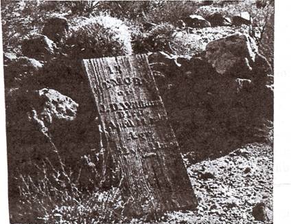
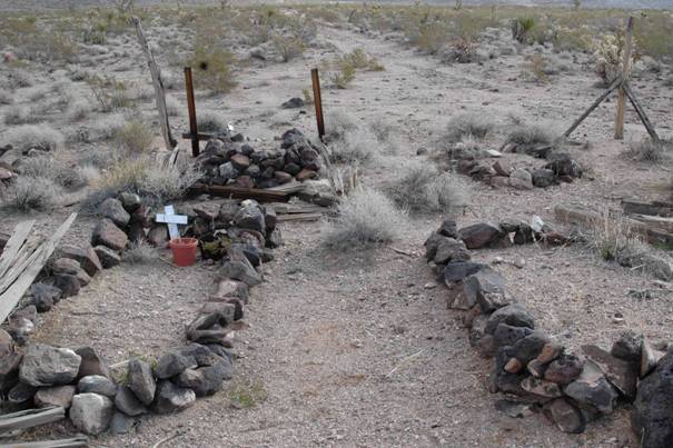
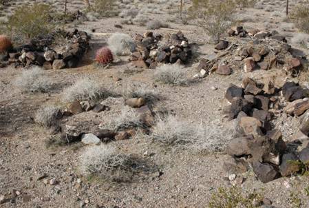
There
were two graves that had crosses on them. One of the crosses had to be repositioned
and put back up. The other one was fairly new and had a flower pot on it, but
there were no flowers in it. It was obvious that someone comes out now and then
to place flowers on the graves of loved ones (possibly family).
I
first completed research on each stone outlined grave. This proved difficult
since it was windy, and I had trouble getting accurate information. There were
a few graves that I am not positive of because of the windy conditions.
|
|
|
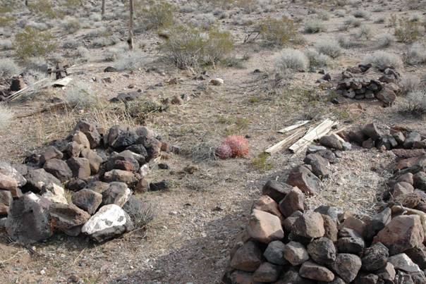
Photo’s Courtesy: Kevin Hart
I
then researched the open space area of the fenced enclosure of the cemetery for
other graves. This proved even more difficult, since I had to walk a line with
the wind. There was even more uncertainty on some of these graves due to the
brisk wind and more research is required to confirm.
Once
I finished mapping and drawing the grave locations in the cemetery, I started
taking pictures of the graves. After taking pictures with about four graves in
each one, I then climbed back on top of my jeep and took pictures of each of
the six rows.
One
of the rows did not have any outlined graves in it, but I was able to find
about seven unmarked graves in it.
I
then proceeded to cut down about six bushes that were growing in the cemetery. I
was hoping to cut more down, but my back started aching so I quit.
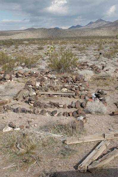
Photo by: Kevin Hart
I
believe the cemetery is in good shape considering its age and remoteness. It is
protected by a fence, which has kept animals out. The rock outlines are also in
good shape. None of the graves are marked with identifiable headstones. There
is some old lumber laying around, which I believe was
used to enclose individual graves.
There
is not much more that we can do to protect this museum of our heritage.
.
1.
The gate could be improved.
2.
There is no mechanism to keep it closed.
3.
It could use a sign to let people know what it is.
4.
We need to research in less windy conditions.
5.
Outline the unmarked graves.
6.
If possible identify individual graves.
7.
Finish cutting down the bushes.
8.
Cut and remove grasses also growing there.
9.
Generally clean up the cemetery.
10.
Find out who owns the mining claims on the east side of the road.
11.
Contact the owners and get permission to look for the second cemetery.
|
|
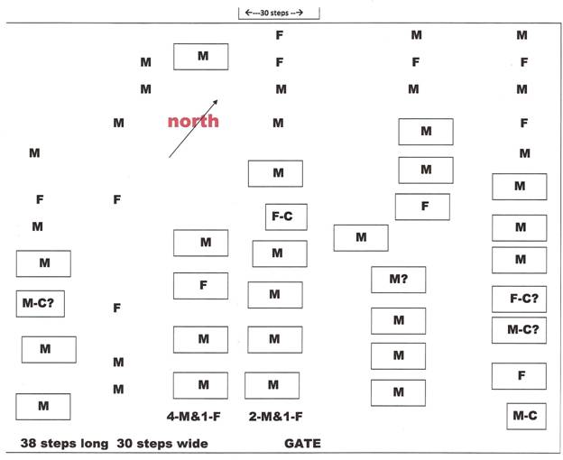
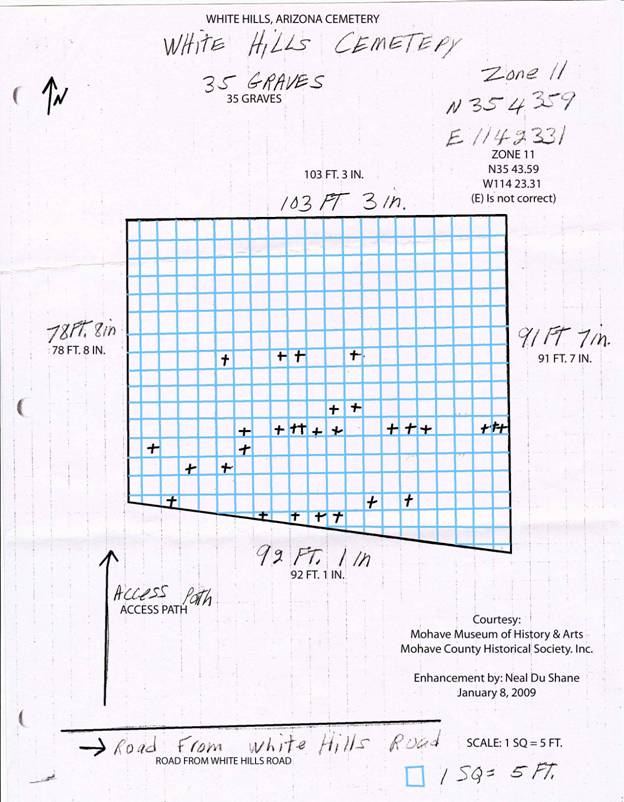
Diagram layout of
graves by: Kevin Hart
With
my research this day I am estimating there could be from 60 to 70 graves in
this historic Pioneer Cemetery. Since history indicates the possibility of two
other cemeteries in the White Hills area and if they each have similar
interments it is possible there are up to 200 to 300 graves combined in all
three cemeteries. APCRP believes this would imply a population from 2,000 to
3,000 residents coming and going during the peak of White Hills history?
Despite
the long drive up and back, it was well worth the time and effort. Next time I
will drive up the night before and stay in a motel and have most of the day to
work and look for the other cemetery and also check out the mines in the hills
just north of the cemetery.
History of White Hills
Courtesy Mohave
Historical Society
White
Hills began unpromisingly when a Hualapai Indian cowboy by the name of Jeff,
was casually asked by Judge Henry Schaeffer “if he knew of any good mine
prospect.”
The
Arizona Republic correspondent in 1894, set many rumors aside when he
interviewed Jeff, quoting the following:
“During
the latter part of 1887, Hualapai Jeff was on his way to the head of the canyon
(now camp White Hills) in search of paint that he had been told existed in that
neighborhood. He found both, the paint
(oxide of iron) and a fine specimen of chloride of silver. He thought the specimen was worth keeping and
later on, while in Mineral Park, he showed the sample to Louis Siebrecht who told him that it was iron ore with no value,
so Jeff paid no more attention to his find.
“In
the winter of 1891, a snow storm was raging and Frank Robinson asked Jeff to
help in driving back some cattle, which had wandered from Gold Basin down the
canyon toward the desert below White Hills (the mountain range.) Jeff... camped for one night near the place
where he was getting paint, which he had found in 1887. . .he accidentally
found a rich silver float. He said
nothing at the time, but in Gold Basin a short time afterward, Judge Henry
Schaeffer. . .asked Jeff if he knew of any good mine
prospect. Jeff brought him a specimen
and he offered Jeff $200 if he would show him the location. . .”
“Jeff
accepted the offer . . . Schaeffer invited John Barnett and John Sullivan to
join him for the trip to the location . . . with Jeff as guide. It was in May 1892 when the three men staked
the following claims: Horn Silver,
Occident, Grand Army (of the Republic), Chief of the
Hills, Treasurer, Norma and Emma. . .” These three men formed a partnership,
excluding Jeff. Judge Schaeffer had his
two partners bond their interest to him for $10,000 backed by a side
arrangement whereby they should have an equitable “divvy”.
. .before he told them of the location.
The Judge told everyone in July 1892 that no Indian was involved, that
he found the original float years previous, and had spent that time since
searching for it.
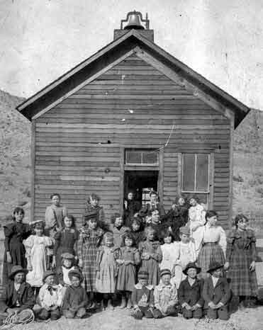
White Hills School
The
scarcity of potable water and lack of tools slowed its growth only
momentarily. The Judge and other miners
gathered (200 by the third week!) to form the Indian Secret Mining District to
have an authority available to keep track of claims. A few men gathered in Taggart’s tent store,
debated and chose White Hills as the name for the new camp, versus Indian
Secret or Schaefferville. A latecomer M. L. Vail, went to Prescott for
a photographer, and mentioned to the local newspaper it should have been named
“Silverado.” As more prospectors arrived
upon hearing of the “strike,” a few “mild knockdowns” and a lawsuit over claim
jumping indicated a major problem . . . that of accurate claim notices. Judge Schaeffer was among those who “became
slightly confused as to the points of the compass”, and according to his words
“avaricious people had the impudence to relocate some of the most valuable
claims.”
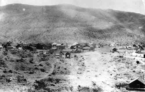
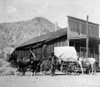
White Hills, AZ
The
boom was on. In the shape of an “L”
about 1 mile in length, countless buildings were erected - homes, a school,
stores, laundries and 12 saloons (7 in a row on Main Street). Town lots sold
for $300 each.
A
post office opened on October 20, 1892 and was discontinued in August 1914.
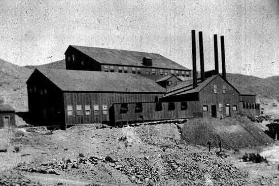
The
rich shipments caught the attention of David Moffat, noted mining man of
Denver, Colorado. He sent D. T. Root to
investigate and in August 1893 Moffat and Root had consolidated most of the
claims into one property under “White Hills Mining Company.”
They
immediately shipped a ten stamp mill from Denver and had it running early in
1894. At this time 500 men were working
on leases, while still more men worked for the company. The mill was successful for two years, when
the Moffat-Root Company sold out in April 1896 to an English company, the
“White Hills Mining & Milling Company,” for $1,750,000. The new company gave the more than 500
lessees on the small claims notice to quit, in effect banishing them from the
camp. Disposing of the old mill as junk,
they built a 40 stamp mill for $150,000.
A
7-mile, 8” pipe line was constructed to springs guaranteed by a “water witch,”
ignoring ample water in the mines for the old mill and promise of more in
depth. A concrete reservoir of 1,000,000
gallons capacity was built, to hold the springs’ water and White Hills was
provided with an up-to-date water supply system, including fire hydrants -
which did not work - the gravity was insufficient for operation. An electric plant, $150,000, was
constructed. Twenty employee houses were
erected and a complete telephone system was installed. All this cost $350,000, even though
considered wasteful management, the company was enabled to continue substantial
production for 4 years because of the large quantity of good ore left by the
first company and by the lessees.
For
a good part of two years after the mill was completed, the south 20 stamps were
run on the low grade ores and the high grade ore shipped as before. But management refused to follow their
company engineer’s advice to development.
The company paid promptly, until last payment came due, causing a
dispute and a litigation, until 1904 when property sold under judgment to
Moffat. In 1911, Moffat failed in
business, at which time the property passed to Mr. Root’s family and litigation
again ensued. In 1922, another attempt
was made to operate, but because of lack of experience and capital, the
property became involved in another litigation which was finally settled in the
early 1930’s clearing the title for the first time in several years.
Despite
$12,000,000 in total ore production for the past six years, in 1898 new strikes
stopped, rich vein’s paid out. Construction and build abruptly stopped - the
cost of living soared, so miners and families drifted away.
By
1899, those few hardy stragglers left were ultimately hit by something more
devastating . . . a flood that inundated the town and its mineshafts. White Hills destiny was sealed. The telephone line was given
over to Chloride. Owners closed everything by 1902. In 1903, a 40 stamp mill was installed for a
short revival, and again in 1920, with the local paper quoting “20 children in
the school” until about 1923. In 1972, a mining company commenced exploration,
but found not enough to warrant expense of full development.
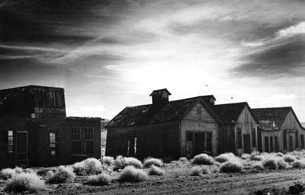
Today,
over a century after the flood, White Hills is considered a ‘true’ Ghost Town
of Mohave County.
Located nearly midpoint on the eastern side of
Detrital Valley, 30 miles from Hoover Dam via Hwy.
93, or 39 miles from Kingman on the same highway, that replaced one of the many
“spider web” roads system. A
road sign announces its presence to the east of the highway.
American Pioneer
& Cemetery Research
Project
Internet Presentation
Version 020309
WebMaster:
Neal Du Shane
Copyright ©2009 Neal Du Shane
All rights reserved. Information contained within this
website may be used
for personal family history purposes, but not for financial profit of any kind.
All contents of this website are willed to the American Pioneer & Cemetery
Research Project (APCRP).