HOME | BOOSTER | CEMETERIES | EDUCATION
| GHOST TOWNS
| HEADSTONE
MINOTTO |PICTURES | ROADS | JACK SWILLING | TEN DAY TRAMPS
American Pioneer & Cemetery Research Project

Collection of information regarding this present
day Historic Ghost Town Compiled by: Neal Du Shane 2006
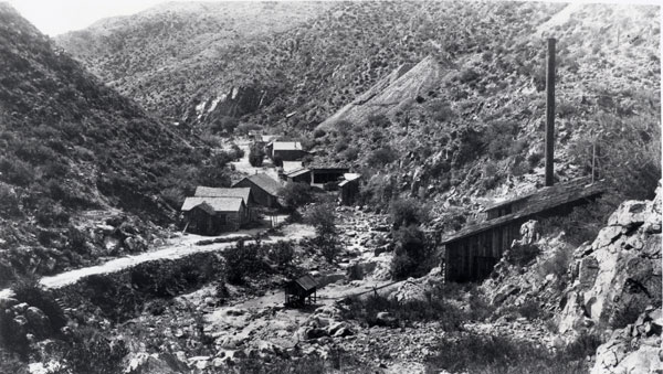
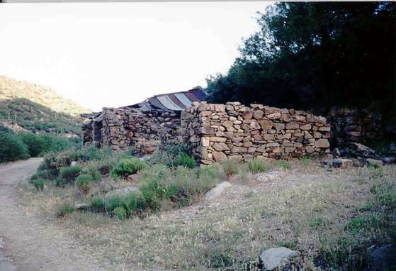
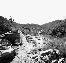
Long-Range View of Tip Top, 2006, Photo by: Neal Du Shane
Table of Contents
Click on Blue hyperlink
below for subject
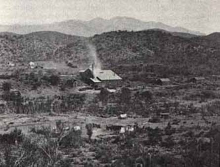
Famous Tip Top Mine Reopened and
in Production
Picture of Tip Top Business
District in 2006
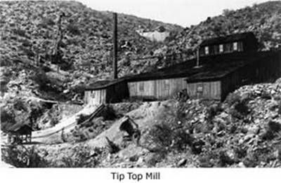
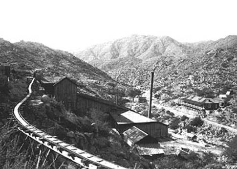
Diagram of Tip Top Mine 50-ton
Flotation Mill
Personal interview of John Siess
From report of A. P. Mater, 1916
Tip Top Mine Ore Shoots and
Workings
Drop In Silver Prices Wiped Out
Tip Top
ARIZONA DAYS WITH ROSCO WILLSON
Gillett, AZ and Mill - Picture
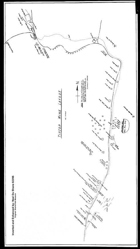
Tip Top Downtown Map (close-up)
TIP TOP & MINE, SEVENTY-SIX
MINE
Directions to Gillett and Tip
Top
Tip Top! - Arizona Ghost Towns
76 Mine, Tip Top District, Bradshaw
Mts (Bradshaw Range), Yavapai Co., Arizona, USA
Tip Top Cemeteries (3) List of
Interments
“She’s a Tip Top Silver Mine”
A couple of prospectors who in 1875 had made a cleanup of placer gold in a desert wash punched their burros into Prescott and, forgetting their good resolutions, proceeded to paint the town red until they had exhausted both themselves and their gold supply. Then, to recoup their strength and maybe find a good mine for another stake, they loaded their burros with grub and tools, secured on the “face” and set out for the Castle Creek Hot Springs to “boil out.”
Not too familiar with that section of the country, Bill Corning and Jack Moore planned to follow the Black Canyon-Phoenix road to the Agua Fria River, thence down it to the mouth of Castle Creek and then up Castle to the hot springs.
However,
when they arrived at the old Jack Swilling ranch on Agua Fria they learned there was an Indian trail through
the foothills that was short cut to the
Jack and Bill were all-around prospectors and as they made their way along the old trail they watched for float closely and examined a number of ledges. They found nothing of interest until they topped a ridge and started down into Cottonwood Creek. Here the formations bore many interesting veins.
At an
outcropping beside the trail they knocked off a few samples which they knew
were rich in silver. They camped that night on
“You said it, Jack,” responded Bill, “and that’s what we’ll call her – the Tip Top.”
And thus the famous silver mine that produced $3 million or more was discovered and a rich silver district opened up that was worked for many years.
Jack Moore and Bill Corning camped on the
When the claims were posted and the location work was done they were about out of grub so Bill took the burros and headed for Prescott to file on the claims, have assays made and replenish the larder. Jack stayed with the claims to hold them down.
It took Bill about a week to make the long trip to Prescott and return, but when he showed up he had a grin on his face like a quarter moon. “Hell’s bells Jack,” he exclaimed, “we’re rich! That damn surface rock ran like a house afire. Three of them samples ran around a thousand ounces, and not one of ‘em less than five hundred.”
Jack was elated, “Did you bring anything to celebrate on?” he asked.
“Yer darn tootin’” replied Bill. “I got a bottle of Old Crow and half a dozen bottles of beer. And,” he continued virtuously, “I never touched ‘em on the way out.”
“Dig out the Old Crow right now, and pull the cork,” cried Jack, dancing around excitedly, “We’ll wet our whistles to the Old Tip Top.”
Jack and Bill had their celebration and then went to work opening the mine and pilling up the rich ore. The deeper they went the better it looked.
Source: State of
TIP TOP MINE
October 26-29, 1917
Author Unknown
DISTRICT: Tip Top,
PROPERTIES: Tip Top Heath, Tip Top Consolidated. Carlisle & Ensign.
LOCATION: 34 miles south of Turkey Creek R.R. (Cleator). Siding by wagon road of which several miles have been destroyed by cloud bursts. Now accessible by 12 mile trail, mostly rough, from Canon. Elevation of camp 2,600. Domestic water from wells & creek.
OWNERS &
OPERATORS: Tip Top Heath Mining & Milling Co. own 3 claims; Tip Top
Consolidated
NOTES: Country rock is pegmatite, sometimes gneissic in structure, which has intruded per-Combrian mioa schist. Blocks and bands of schist are included in the pegmatite, and some have been more or less completely absorbed. The pegmatite in contact with the schist is generally of finer texture than the main mass, no doubt as a result of cooling more rapidly. Local miners speak of “porphyry” in the ore bodies, but this appears to be the finer grained pegmatite and not a separate intrusion. A fractured zone with a general strike NE – SW and dipping NW has followed lines of least resistance between pegmatite and schist and the narrow fissures have been filled with silver and tungsten bearing quartz, the schist appearing on either wall, so that local miners consider schist favorable for ore. Tow parallel narrow quartz filled fissures, about 20’ apart on the surface are called the hanging and foot wall veins, prospectively. They are said to come together in depth on the 400’ level. The vein quartz is distinguished from the quartz in the main mass of the pegmatite by its banded structure and cavities sometimes filled with quartz crystals. In the bands and seams of the vein quartz antimonial silver, stephanite and pyrargyrite (brittle & ruby silver), occur in association with tungsten minerals, chiefly wolframite. Bunches of zinc blend show up as crystals in quartz occasionally. Native and horn silver are said to have been found on the surface. While there are no authentic records available, there is some evidence that the mine produced nearly two million dollars worth of silver between 1875 and 1883.
The Original workings were on the South Top claim, but the pay ore appears to have extended only a few feet from the portals of the adits on this, the S W side, of the gulch and to have also ceased in depth in an un-timbered shaft, said to by 80’ deep, at the mouth of the lowest adit. On the N E side of the gulch, the mine workings are reached by an adit called the 200’ level, 1,275’ long, and connected with the main shaft, which is located about 400’ from the North end of the Tip Top claim and is said to be 800’ deep. Water stands in the stands a little below the 200’ level and the main shaft. From a point 200’ from the portal of the 200’ level, more or less stopping has been done and some ground left for a length of 600’ This six hundred feet is all called a pay shoot, but my impression is that the ore occurred in high grade bunches, and that the vein did not average over a foot in width, although I say one place where the vein was three feet wide.
At various time “Chloriders” have worked over the stopes from the 300’ level up, as well as the surface dumps and it may be presumed that most of the obviously high grade accessible ore has been removed. A sample across 16” of quartz in the breast of the 200’ level assayed (H 351) silver 0.38 oz; Tungstic Acid, trace. A sample across 26” in the stope, 10’ S W of No 4 chute (one of two chutes now open) assayed (H 352) Silver 4.50 oz; Zinc 0.7%; Tungstic Acid, Trace. The manway here leads to the 100’ level, above which the ore has been mostly stoped. At the mouth, a sample across the whole 5 feet belt of intercalated quartz pegmatite and schist assayed (H 350) Solver 3.70 oz: Zinc 1.1%; Tungstic Acid, nil. It is hardly possible to estimate the amount of unbroken ground or stope filling as even the ground above water in only partly accessible.
It is said that no ore was found in the main shaft above the 200’ level. The dump from this shaft must also contain considerable waste from development work.
DISTRICT: Tip Top Mining District,
STATEMENT BY:.
DATE: About 1917
NOTES:
This district is in the Southern foothills of the Bradshaw Mountains and borders on the Southern boundary of the County and West of Blank Canyon thoroughfare from which it is accessible, most of the year, by vehicles.
CLIMATE:
The general trend of the South Bradshaw range is easterly and westerly, while ranges forming its southern bases extend southerly. Among these latter and lower ranges nestles the Tip Top Mining District that is protected from north winds in winter. Our atmosphere is clear, light and dry that the heat of our long summers is not so oppressive as to cause “sunstroke” and like ills, to those working in the open.
THE FORMATION:
In this mineral zone the rock is practically granite, altered granite or schists, interrupted or crossed by several large and continuous dykes of ryolite (so large that they are easily traced throughout the District) that have a course of strike almost true northeast and southwest. In this District are three series of veins knows as the Tip Top series, the Great Cross Cut series and the Gold series of veins.
THE TIP TOP SERIES OF
VEINS:
In this series of veins are very many rich silver ore veins ranging from one inch to four feet in width, and their usual trend or strike is north of east and sough of west. Of these veins there are an untold number, and of which the Tip Top Mine is on of the veins.
THE TIP TOP CAMP AND
MINES:
At one time this camp was the trading center of the District and numbered about 600 men, of which about one-half were “chloriders” either working their own ground or leasing from others. Most of the other 300 men were employed by the Tip Top Company.
L. F. S. Holland
No date
The mill contains two small gas crushers, a revolving screen, a Denver Roller Mill, whose capacity was 7 tons of the ore in 24 hours; a Callow cone; a Richards Classifier; a Wilfley Table and a Diester Slimer. The mill is driven by a Fairbanks Morse 16 H.P. engine using “tops”, and there is a 10 K.W. Westinghouse D.C. Generator for lighting, etc. There are the remains of a old roasting plant, and pan amalgamators, used in the early days.
Famous Tip Top Mine Reopened and in Production
July 30, 1936
By J.S. Coupal * reports - Mining Engineer, Canon, Arizona
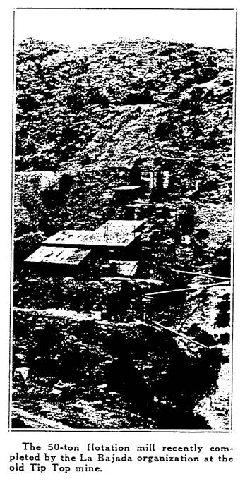
From 1876 to 1884 Tip Top, Tombstone and Wickenburg were the three most active mining camps in Arizona. After 40 years or more of comparative idleness the camp of Tip Top has been rehabilitated, a 50-ton flotation mill has been installed and is now operating, the mine has been re-opened, and the property is maintaining steady shipments of high-grade silver concentrates to the smelter at El Paso.
The property was discovered in 1875 by John Corning and Jack Moore. They had been working in and around Prescott and had been interested in the reports of rich strikes in the then active gold placers on Humbug Creek. It was slow travel in the early days and they spent the night at the Swilling ranch – at the junction of the Black Canyon and Agua Fria rivers – where Canon is no located.
Map of Tip Top
Source: Sharlot Hall, Picture Inverted and Enhanced
by: Neal Du Shane
Early next day they took the Indian trail for Humbug Creek which crossed Boulder Creek and they over a pass into Cottonwood Creek. After making the pass and going down hill to Cottonwood Creek, they noted high-grade silver float on the hillside. They decided to make camp on Cottonwood Creek where they found good water and abundant shade.
The float was traced up hill and the out crop of the ledge from which it had come was located. Three claims were staked out, the discovery work done, and some of the high-grade specimens taken to Prescott. At Prescott they took in two partners and returned to work the property. Within a year’s time, they took out and shipped about $80,000 in high-grade silver ore.
The ore was packed by mule back to the claim and wagon to Ehrenburg, on the Colorado River, where it was shipped down stream to the Golf of California and from there to the smelter at San Francisco.
These shipments of high-grade ore, which ran from 500 to 1,000 ounces silver per ton, attracted the attention of Haggin, Head, and Hurst interests in San Francisco. After looking it over they purchased the property for $60,000 cash and worked it from 1876 to 1884. An inclined shaft was sunk to a depth of 500 feet and levels were driven on the ore every 100 feet, opening up an ore body 600 feet in length. A 10 stamp chlorination plant was erected in Gillett, on the Agua Fria Rivers, a distance of about six miles from the mine. The ore was packed mule back part way by a receiving bin from which it was hauled by wagon to the mill. During this time a production of between $2,500,000 and $3,000,000 in silver was claimed.
The ore body ranked to the northeast and in spite of the shaft and lower workings did not develop the high-grade bonanza ore which had been found about the 500’ level. The mine and mill were shut down and the property abandoned in 1884. The owners did not keep up any assessment work and the property was relocated by Dan Wright and Tony Beauchamp in 1885- 1886. They also took in two partners and continued in the workings above the 200’ level for about a year’s time. The property was then sold to St. Louis interests for $15,000 and a company organized called the St. Louis-Yavapai Mining Company. The four men who had sold the property received a lease on the ground above the 200’ level and they worked continuously up to 1893, taking out about $85,000 in ore.
The St. Louis-Yavapai Company dismantled the mill at Gillett and moved and re-erected it at the mine. The inclined shaft was sunk to a depth of 830 feet and a level made at 800 feet. The ore shoot had passed out of the shaft due to its rank, at about the 800’ level so a drift was driven to the northeast and the ore packed up again. About 100 feet from the shaft a winze was sunk 50-feet deep on the ore and it continued to the bottom. Ground between the 500 and 800’ levels was partially stoped.
No figures as to the production at this time are available, and the company shut down in 1888. The leasers continued to work until 1893 when the price of silver dropped and the camp was practically deserted. In 1895 the property was again relocated, this time by Frank Wager and his brother who held it until 1920, when it was taken over by Frank L. Carlisle of Pittsburg, Pennsylvania, on a mortgage.
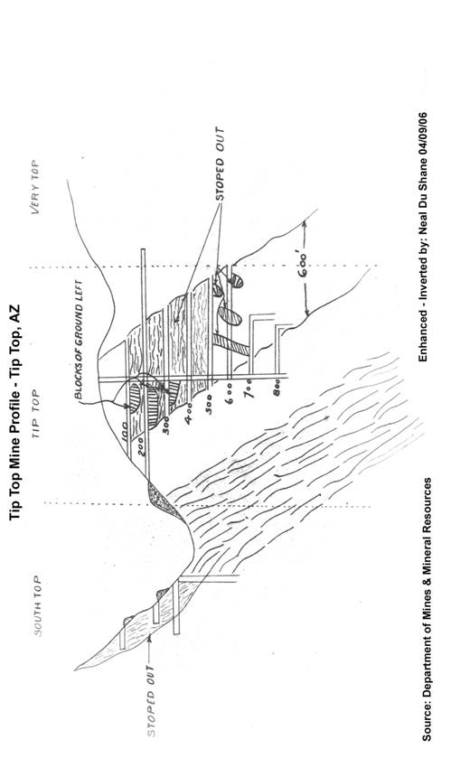
Profile of Tip Top Mines
Source: State of Arizona Department of Mines & Mineral Resources Picture Enhanced by: Neal Du Shane
In the early days when the ore was closely hand sorted before shipping, a heavy black mineral, considered to the black jack or sphalerite, was discarded with the waste and second-class ores. Frank Wager, who was an assayer, noted the characteristic needle-like crystals, tested and found it to be wolframite, the tungsten mineral.
When tungsten soared to high prices during the war, Elliot and Muter put in a Denver quartz mill and worked the dumps and stope fills above the 200’ level for tungsten. The property was partially unwatered in 1919 by the writer. Oklahoma and St. Louis interests took an option on the property, did some development work, excavated for a mill, and quit. Since then little or no work was done until this year (1936).
The district is located in the extreme southern part of Yavapai County, about 10 miles west of the Black Canyon Highway at a point 42 miles north of Phoenix. It lies at the southern end of the Bradshaw batholiths, the higher altitudes of which show the rugged outcrops of the Bradshaw granites. The margin or border phases of the batholiths are exposed in and around Tip Top include gneisses, schist’s, and abundant pegmatite dikes.
The district is traversed in an easterly and westerly direction by a series of rhyolite dikes, dipping northerly. These dikes are cut out by a fault system along and in which mineralization has taken place. It is this system of faulting and mineralization which constitutes the veins and ore bodies of the district. The westerly section of the district yields primarily gold ores, while in the easterly section, as at Tip Top, silver ores predominate.
The most important veins in the immediate district are the Tip Top and the El Dorado. These veins are sharply defined fissures, varying from a few inched to two or more feet in width where they form minable ore bodies. The veins are very persistent in length and may be traced for several miles. The gangue is essentially quartz, with some barite and ore minerals are wolframite, arsenopyrite and galena, with which the high silver values occur. Ruby silver and horn silver form the high-grade silver minerals.
The Tip Top Mine has been filled with water, seepage and surface waters, up to the 200’ level which is an adit level connecting with the 800-foot inclined shaft. The vein strikes northeast and southwest. The ore shoot, about 600 feet in length, has a rake in the vein of about 60 degrees to the northeast, which is typical of most of the ore shoots in the district. The inclined shaft entered the ore shoot at a depth of about 250 feet and passes through it at about the 800-foot level. Drifting on the 800-foot level and winzes sunk show the ore to persist in depth.
Picture of Tip Top Business District in 2006
L-R Original Assay Office, Beer Parlor/Brewery, in
2003
Down to the 500’ level, the major part of the ore has been stoped. Several pillars, however, have been left standing. From the 500 to the 800-foot level only small chloriding stopes have been worked. The ore was broken and roughly stored in the mine, the waste being used as back fill. As a result the stope fills carry sufficient ore to make them profitable. There are several thousand tons of mill-grade ore in various dumps.
The operating plans of the present company are to continue to mill the better grade section of the dump, pull the stope fills, and break down the various pillars which remain in the stopes. This ore will be milled and water in the mine used for milling. As the mine is unwatered it will be put in shape in the lower levels for continued mining.
The mine is equipped with a full gravity flow 50-ton flotation mill. Ore passes from a 14-foot diameter by 16-foot high circular cause ore bin, with 7-inch grizzly on top and a quadrant ore feeder, to a one-inch grizzly, at the bottom of which is a four-foot by five-foot sorting table. From 15 to 20 per cent of waste rock is hand sorted and trammed to the dump. The balance of the ore is fed to the Fraser-Chalmers gyratory, crushing to one-inch size.
The fines (through the one-inch grizzly) and the crushed ore land on a 30-foot by 14-inch conveyor belt and are carried to the fine ore bin, which is the same size and type as the coarse ore bin. The crushed ore is fed from the fine ore bin by a Challenge ore feeder to a 45-inch by 45-inch Darbyshire-Harvie ball mill, equipped with a combination center and scoop feed. The ball mill is in closed circuit with a 54-inch by 16-foot Dorr-Duples classifier, and grinding is to about 60 mesh.
The overflow from the classifier goes to a five-foot by five-foot conditioner tank where the reagents are fed; the pulp going into a six-cell Weinig flotation machine. Two of the six cells are used as finishing cells and four as roughing cells, the roughed flotation concentrates going to the two finishing cells to be cleaned. The finished concentrates go to an eight-foot V cone thickener and then to a four-foot, three-leaf American filter, and are spread and dried.
 The tailings from the flotation machine go to
two Deister tables and the concentrates from the tables, carrying
tungsten content,
are stacked and stored for future treatment. The tailings from the table go to
a homemade screw classifier for de-sanding and discharging with a low
water content. The overflow from the classifier then goes to an 18-foot
diameter by eight-foot high Dorr thickener. The overflow water from the
thickener is pumped back to the return water tank and the thickened slimes go
to waste.
The tailings from the flotation machine go to
two Deister tables and the concentrates from the tables, carrying
tungsten content,
are stacked and stored for future treatment. The tailings from the table go to
a homemade screw classifier for de-sanding and discharging with a low
water content. The overflow from the classifier then goes to an 18-foot
diameter by eight-foot high Dorr thickener. The overflow water from the
thickener is pumped back to the return water tank and the thickened slimes go
to waste.
The mill is powered by a 120-horse-power Atlas Imperial Diesel engine with a V-belt drive, 100 kw General Electric generator. The various units in the mill have individual motor drives, using V belt drives in most instances. The power for mining and pumping of water is supplied by a 308-cubic foot Chicago Pneumatic hot head, compressor which also supplies air for a Sullivan drill sharpener.
The ore is a hard quartz and is crushed to about 60 mesh, and a recovery of from 80 to 85 per cent of the silver values is made. The ratio of concentration is about 80 to one. The flotation reagents, butyl Xanthate, Aerofloat, and sodium sulphide are used.
Provided by: State of Arizona Department of Mines
& Mineral Resources
Diagram of Tip Top Mine
50-ton Flotation Mill
Source: State of Arizona Department of
Mines & Mineral Resources
TIP TOP MINE
Note by G.M. Colvocoresses, October 1937
Shappell seemed to have dropped out of this picture by the end of 1935 and Coupal took it back again in 1936, built a mill and operated until the middle of 1937.
He shipped quite a tonnage of high grade ore and concentrates but has not quit and operations have been discontinued. Apparently he was working on a shoe string and could never quite pay for his equipment or meet operating expenses.
DeCamp once made a careful investigation of this mine (for other parties) and told me that he believed that further development was warranted.
I do not think that any of the attempts which have been made to operate this mine since 1917 have been properly financed nor had the benefit of good technical management and I think that it merits further attention in view of the favorable outlook for both silver and tungsten and recent advances in metallurgical practice.
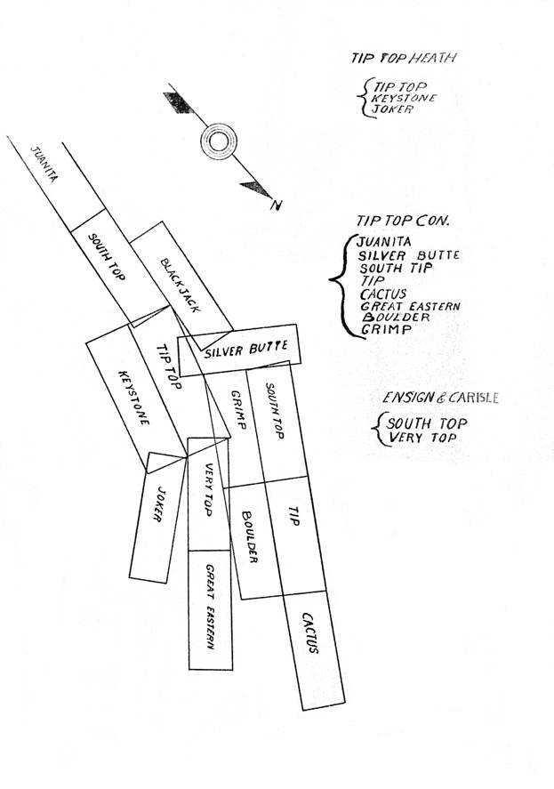
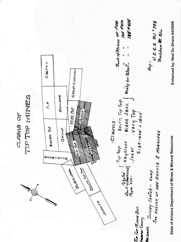
The original Tip Top Mines consisted of the east and west Tip Top Claim and the Joker claim, but not include six claims. The original discoveries of the Tip Top Mines (Corning & Moore) made quite a shipment of ore to San Francisco, along in the late 70’s (1870’s) that brought them $10,000.00 per ton. It is said that this shipment or ore (from the Tip Top South) caused the first sale of the Tip Top property. On the Tip Top there is a shaft following the vein down at an angle or pitch to the north of about 68 degrees to a depth of 830 feet. Down as far as the 700’ level the ore was frozen to both walls, however, on the 800’ level a fine showing of gangues is found with the ores. The Tip Top Mines have yielded to date over $4,000,000 worth of silver and today there remain between 300,000 and 400,000 oz. of silver in their dumps, besides many hundreds thousands of dollars worth of ore in the stopes and in place in the mines.
Map of Tip Top Claim
Tip Top ground and quartz is usually exceedingly hard but brittle. This quarts at the surface contained, as a base, hematite of iron, a small percent of zinc (black jack); also a small percent of antimony, the latter in the form of brittle silver (antimonial silver), usually assaying around 3,000 oz. per ton and often ruby silver was had. Also tungsten, usually ferberite or iron tungsten is frequently found in these mines.
Silver at the surface was found in the form of chloride of silver, horn silver and red oxide of silver. In the lower workings the silver was found with iron pyrites, antimony and black jack. The black jack is usually carrying from 200 to 400 oz. silver.
The antimonial silver and the black jack is usually found interspaced throughout the iron pyrite ores, also often the brittle silver carry the ore values up to 3,000 oz. silver per ton. However, I have seen pieces of ruby silver; brittle silver, black jack and iron pyrites combined ores as large as an ordinary water bucket that carried an assay value of 5,800 odd oz. silver per ton. In this camp, the ores of this series of veins carry but very little or no gold.
THE TIP TOP MILL
Two batteries of 5-1, 060# stamps each, a White & Allen revolving roaster, 4 pans, and two settlers and accessories, was erected on the banks of the Agua Fria River 9 ½ miles distance from the mines, to which the ores were first transported by pack animals. Later about half way by pack and the balance of the way by wagons, then ultimately by wagon the whole distance of the nine and one-half miles. The management contended the owing to the high cost of extracting the ore (mostly single jack work with miners at $4.00 per 8 hour shift and there never has been a power drill in these mines) and owing to the high cost of salt, etc., anything less than $250 would not pay them. Hence the rich dumps and stopes and ores left in place in the Tip Top Mines. The tungsten ores usually lays in lenses throughout the silver ore chute, and very little of it was extracted for its silver content.
 I
am mentioning Tip Top Mines in particular to show that these ore veins of high
grade ores go down. This series of veins are very persistent and some of them
can be traces several miles. As one Mining Engineer of large experience (who
was in this District for several months, sampling for tungsten) said, “I have been in many
mining districts, I have been in districts where the veins run in all points of
the compass; every which way, but I never was in a district before where the
veins were so d__ed persistent as they are in this district.”
I
am mentioning Tip Top Mines in particular to show that these ore veins of high
grade ores go down. This series of veins are very persistent and some of them
can be traces several miles. As one Mining Engineer of large experience (who
was in this District for several months, sampling for tungsten) said, “I have been in many
mining districts, I have been in districts where the veins run in all points of
the compass; every which way, but I never was in a district before where the
veins were so d__ed persistent as they are in this district.”
To return to the Mill, along in 1886-7, the Tip Top Mine (then known as the Conquerer) and the Mill on the Agua Fria River were acquired by a company known as the St. Louis Yavapai Mining and Milling Company and the Mill in-total moved to the Tip Top Mines, where it was installed on their property and concentrators were added thereto. This Company extracted about $235,000.00 worth of ore from the dumps of which they saved about one-third of the values. Some of the richer dumps, containing the oxidized ores, they could not handle to a profit at all. It has since been found that all these ores are highly susceptible to cyanide treatment.
I am satisfied that there are at least 40,000 tons of dumps remaining on the Tip Top and on the Tip Top South, from which mass at least 20,000 tons of ore and matrix can be had that will average better than 15 oz. silver per ton.
I.O.A. Ensign, came into this mining camp in the year 1878 and have been intimately interested in the mines of Tip Top Mining District ever since and know whereof I speak.
Source: State of Arizona Department of
Mines & Mineral Resources
Personal interview of John Siess
In Cigar Store in Prescott 1946, Sept. 5th
Written by: Claude C. Findly, Nov. 1947
Mr. John Siess states he was in the lower levels of the Tip Top in 1892 and helped remove the tools when the property shut down. Said ore was mined out above the 600, 700, and 800’ levels, and the ore shoot on the 800’ level extended only as far North as the map shows, and then pinched down to a couple of inches which wasn’t followed. Did say last Lessees sank a winze on the 800 at the North End of drift in good ore and wanted a lease below the 800 but the Company would not give them a lease so they quit the property and that was the end of the work at Tip Top.
Siess is 80 years ole, seemingly in perfect health, clear minded and bears an excellent reputation.
---------------------------------------------------------------------------------------------------------------------
Interview with Mr. Theo. Wade, at his home, 4226 North Second Ave, Phoenix, in presence of Mrs. Wade and Mrs. Findly.
Mr. Wade was pensioned from Phelps-Dodge, Jerome, AZ in 1945, age 76. High class man, in good health, active, alert and clear minded.
Stated: Was a trammer on bottom level of Tip Top 1886, about 16 years old. Said mine stoped out above bottom drift. Bottom drift not long line ones above. 500 seemed especially long. Said ore at bottom drift about one foot to 14” wide (indicated with hands) and was ruby silver, very rich. Said he thought shaft below 500 in very hard ground and would probably be in good shape except probably pretty well filled with much by high graders throwing waste in it. Said they called rock where shaft was Syenite. Said picked up high grade float North of Tip Top shoot on same vein. Also said got 10 tons of 740 ounce ore out of Arizona claim from shallow shaft. Said Tip Top always narrow, foot or so. Said cover sand 100’ and drifted and didn’t hit ore and had to cross-cut back towards foot wall to hit ruby.
Comment;
Comparing Siess and Wade statements seems to writer Cover and Tyack probably did not sink another 100 foot but probably did put winze down from the 8th level. Both seem to agree the mine all stoped out above the 8th level but they probably mean all high-grade. Both seem to agree high grade ruby in bottom.
I know Wade is still available for interviewing. I don’t know whether Siess is available or not. (NOTE: Written in 1947)
Claude C. Findly Nov.
1947
From report of
H?????rmitage, 1911
“However, it is supposed that a very rich shoot of ore cropped to the surface where the shaft was sunk, and the object was to take out this rich ore without taking into consideration that there were all probability other shoots just as rich as the one that would have been developed by levels run from the shaft at a more accessible point”. “The mine is not worked out; on the contrary not one twentieth part of the vein has been developed”.
From report of Geo. W. Alsdorf, 1916
“On the Tip Top claim there are three parallel veins all of which have produced high grade ore. The hanging wall vein is 8’ to 12’ from the middle vein and has produced silver and tungsten years ago according to reports but has not been reopened due to a cave in, in the cross-cut leading from the tunnel to the middle vein. The foot wall vein is about 20 feet from the middle vein and dips at 45 degrees to the northwest while the middle vein also dips at 55 degrees to the northwest. These two veins are said to intersect at the 350’ level where the vein widens. Most of the development work has been done on the middle vein which consists of an 800’ inclined shaft”.
“The Joker claim has a strong showing on the surface where the vein has not been stoped. The vein which runs in the general direction of the Tip Top Vein can be developed very easily by extending a cross-cut already started from the so-called Tip Top Vein”.
From report of A. P. Mater, 1916
“The mine has been stoped only above the 500’ level on the footwall vein, but all through these stopes are low grade blocks of ground that were to low to work in the early days. By drawing some of the chutes above the two hundred level we have uncovered several of those low grade blocks, aggregating about 1,000 tons of ore that will average 40 ounces of silver and .8% tungstic acid.
The handing wall vein was stoped to a depth of 150 feet which leaves a block of ground between the 150’ level and the 350’ level of 200 X 600 X 2. Three thousand pounds of ore taken from the vein as a sample gave returns of 167 ounces of silver per ton. According to the statement of the present foreman of the mine who was a shift boss when the property was first developed and a Lessee under the St. Louis Yavapai Co., There are low grade blocks of ground all the way from the 500’ level to the surface of the same grade he uncovered above the 200’ level. He also states that tungsten accompanied the silver all thru the mine and that in places the tungsten vein practically replaces the silver vein. Whenever this happened the ore was left standing in place, or left in stopes, as it was thought in the early days that the tungsten was zinc. Some 12 or 15 men whom we have interviewed, who worked in the mine in the early days are willing to substantiate the above statements”.
“As proof of the value of the mine below the 500’ level we cite the production of Cover and Tyack from a lease on a block of ground between the fifth and sixth levels. In Ninety days these lessees produced 150 tons of ore that averaged 557.26 ounces of silver, which at present prices worth $41,152.50.
Also the statement of Mr. Waldemeyer, the foreman, who says that just before work on the property was stopped the exposed a vein of fine ore two feet wide on the Eighth level”.
While it may have been possible in 1911 or 1916 to find men who worked in the Tip Top prior to 1892, it is almost impossible now but I was fortunate in 1946, last year, in interviewing two, a Mr. John Siess, resident of the Pioneer’s Home at Prescott, and Mr. Theo. N. Wade, 4226 North Second Avenue, Phoenix, Arizona.
From my notes I copy the following:
TIP TOP TUNGSTEN MINE
The property of Tip Top Mines, Inc., situated in the Tip Top Mining District, Yavapai County, Arizona, being 43 miles North of the Black Canyon Road, and eleven miles West in the Eastern part of the Bradshaw Mountains. The mine, the District and other properties in the District are almost forgotten as most of the work done there was accomplished more than sixty years ago. (Written in 1947)
The Tip Top Mine produced more than $4,000,000 prior to 1892. All shipping grade silver ore. Tungsten appears frequently along with the silver.
A very well mineralized District. Would easily support a custom milling plant. Values mostly silver, but gold and tungsten also. All year climate, winter ideal working season.
The Tip Top Mine closed down in 1892 and no one has been below the 500’ level since the close-down.
The Tip Top property comprises three patented and three unpatented claims.
Development work and exploration will be necessary before any production plans should be formulated and suggested exploratory work is set forth in the following paragraphs as a guide to your field engineers in checking the possibilities of the property.
On the early map of the Tip Top Mine workings, enclosed herewith, you note indicated ore shoots both Southwest and Northeast of the ore shoot worked. Surface surveys will probably verify the location of these ore shoots. I am of this opinion these ore shoots, while a continuation of the Tip Top Vein, offset as faults occur along the vein and the vein while running in the same general direction, steps forth to fifty feet East or West, ass the case may be, on either side of these faulted zones.
I would suggest the advisability of continuing the Tip Top Adit tunnel Northeast through the faulted zone and the cross-cutting both ways to determine the direction of the throw. This should open up the new un-worked ore shoot to the Northeast.
On the Southwest un-worked ore shoot, I would suggest cleaning out the discovery shaft there and then drifting northeast to reach the ore shoot, if no ore is encountered, after the determined footage of drifting is accomplished, cross-cutting there also.
To the Northeast and adjoining the Tip Top Claim is the Joker claim thru which the Joker vein runs. It is reported that the Joker produced $350,000 in the early days from shallow workings. Very high grade silver ore, good tungsten but tungsten considered black jack or zinc in early days. By driving a cross-cut from the Tip Top Adit tunnel to the Joker vein, a distance of about 275 feet, you should intersect the Joker ore shoot at a point below the stoped out workings, provided the cross cut is engineered to intersect the Joker vein at a point determined by taken into consideration the rake of the Joker ore shoot. This cross cut would hit the Joker vein abut 500 feet down and 350 feet under the early stope. The cross-cut to the Joker vein, noted on the enclosed map, supposedly was never completed and was driven on a short distance when all operations ceased. It is doubtful if the cross-cut from the 500’ level of the Tip Top would have intersected the Joker vein on the ore shoot working above.
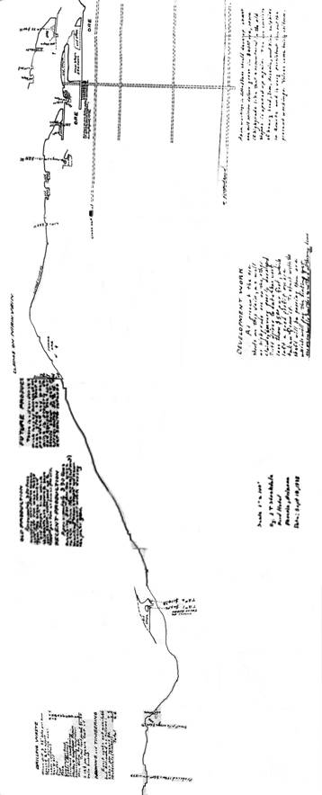
Tip Top Mine Ore Shoots and Workings
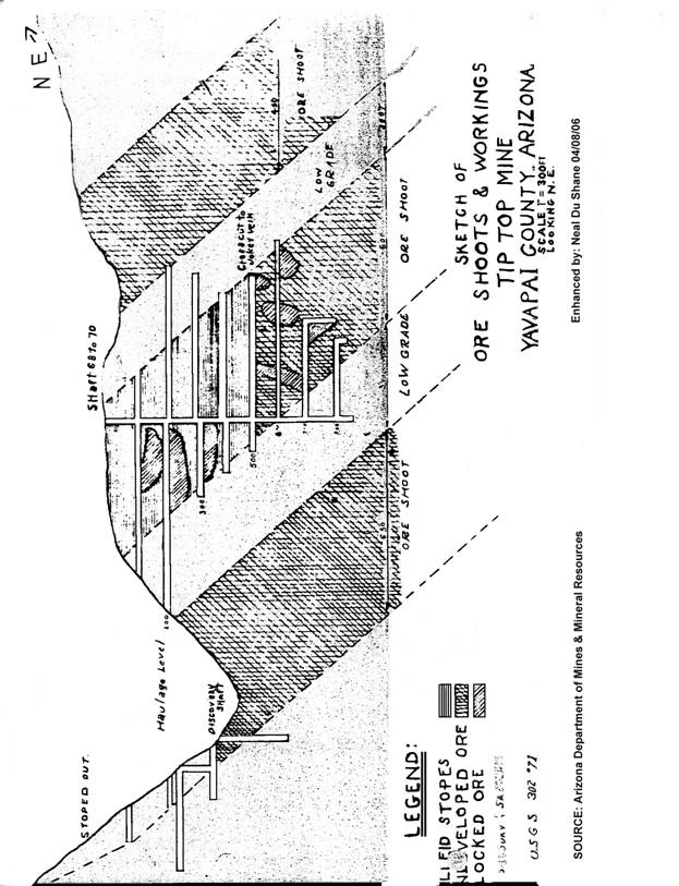
A cross-cut to the West from the Tip Top Adit tunnel will cut the Black Jack vein from which floated running is high as 180 ounces of silver to the ton has been picked up from the surface.
All the work suggested will be inexpensive as no hoisting will be required with the exception of the work on the Southwest indicated ore shoot on the Tip Top Vein. There should be sufficient stope space to fill in the waste from work done on the Tip Top Tunnel level and very little of the waste would have to be trammed to the ???t of the tunnel.
After the above work is accomplished and if the results are as anticipated, then the information and knowledge gained from that work would justify the immediate opening of the Tip Top Mine lower levels. You will note from the enclosed map that the Seventh level drift only went in about one-half as far as the 500’ level and the Eighth Level only about 140 feet. Since the Tip Top ore shoot was 624 feet long on the surface and about an average of two feet in width, the map would indicate a fault coming in on the Northeast on the Seventh and Eighth Levels. If the work done on the Northeast end of the Adit tunnel level proved the continuation of ore on the two hundred level and gave the direction of the throw, then by cross-cutting the same direction in which ore was encountered on the 200 Adit level, on the Seventh and Eighth levels, the ore should be opened up on these levels the full 624 feet of the ore shoot. The best information I have is that on the Eighth Level, in the bottom, is about fourteen inched of red ruby silver ore for the distance they had ore, approximately 140 feet in length according to the enclosed map. The character of the vein and the geological conditions present would indicate extreme depth of the enrichment, and the fact ruby silver is in the bottom of the Eighty Level seem to prove this fact.
This property hasn’t hardly been scratched even though it produced over $4,000,000 prior to 1892. If this suggested small exploratory campaign seem warranted, and is then carried out, and results are as expected, millions of dollars of production will be available. The District is almost virgin. Dozens of veins would support workers profitably if milling facilities were made available.
Cost figured at $20.00 per foot for drifting and cross-cutting which is estimated to be about the right cost estimate for this exploration should not exceed $5,000 for cleaning out Discovery shaft on the South Tip Top and drifting to the ore, even allowing foe some cross-cutting at the end of the drift if the ore is not encountered by straight drifting; $5,000.00 for drifting and cross-cutting at the Northeast end of the Tip Top Adit tunnel; and about $5,500.00 to cross-cut from the Tip Top Adit tunnel to the Joker, and a like amount fro cross-cutting from the Tip Top Adit tunnel to the Black Jack vein, or a total exploration expenditure of approximately $19,000.00. This $19,000.000 should cover cost of moving in the necessary equipment, cost of supplies, labor and supervision. The work should take from sixty to ninety days, two shafts per day with work carried on simultaneously at the different locations. Area opened up from this work, even if not warranting rehabilitation of the Tip Top Mine Old workings, or further underground development, should repay the above expenditure many times over. Shipping grade ore could be encountered at each or all these cuts, and wherever encountered, will open up a tonnage of ore above the point of encounter.
The map attached hereto shows very little stoping below the 500’ level and was probable made around 1887, at the time the Company operation ceased. From 1887 to 1892, the owning Company leased blocks of ground, and Mr. Theo. N. Wade, 4226 North Second Avenue, Phoenix, Arizona, retired in 1945 from Phelps-Dodge, Jerome, states he was tram boy on the Eighth Level for John Cover, Lessee, when the work stopped and as he remembers all the ore above the Eighth Level had been stoped out.
Tip Top Mine Profile
This is a valuable property. Ore at the property has run up to thousands of ounces per ton. Tungsten appears throughout. I have seen pure chunk of Wolframite, and the dump there now will average .25% tungstic acid. All the $4,000,000 production was shipped grade ore and at a time when it is reported transportation costs were $200.00 per ton both in and out. It is worth of, at least, a week or ten day investigation by your most experienced and conservative Engineer. I will assist with any data I have and will furnish a man familiar with the property and the district to accompany your representative in any investigation you care to make.
Offered preferably on Long-term lease, no money down, 10% royalty rent on net smelter returns or mint returns on bullion or concentrates, and 15%, 20% and 25% royalty, on sliding scale, on net smelter returns on ore shipments, or on a ten-year lease and bond with down payment. If Long-term lease is preferred, the suggested exploratory campaign will either have to be consummated as a condition of the lease, or a rather stiff guaranteed royalty will have to be paid, in Lieu of such exploratory work.
Rather than return this presentation to me after it has served its purpose, would appreciate your retaining it in your files for possible future reference, or turning same over to possible interested parties.
Thank You,
Claude C. Findly,
Vice-President, Tip Top Mines, Inc.,
P.O. Box “Q”,
Wickenburg, Arizona
November, 1947
TIP TOP MINE
YAVAPAI COUNTY - Tip Top District. May 27, 1957
This property inactive - Mark Gemmill
Production to 1890 $2,200,000 silver, major metal, J. W. Still's figures (correspondence file)
Aleta Phillips had a conversation 7/12/79 with Howard R. Johnson, 1421 Luthy Circle N. E., Albuquerque, N. M. 87112. He stated he is the sole owner of the Tip Top Mine, Yavapai County. He also said he is the person to contact in regard to this mine. The claims of his are El Dorado Group (6), and the Tip Top (4) all unpatented. 7/19/79 a. p.
Ken Phillips had a conversation with a person in the office 6/29/79 and this person said that he supposedly was going to get permission to go on the Tip Top Mine, from Tip Top Mining Corp., St. Louis, Missouri, Richard J. Ambler, President, whom, he stated is the owner. 7/ .9/79 a. p.
RRB WR 8/15/80: Howard L. Johnson, 45 Woodside, Prescott, Arizona 86301, phone 778-4988, reported that he has (with Nuclear Corp of Albuquerque as a 50% partner) 26 claims in three groups in Sections 8, 9, and 10, T8N, R1E, Tip Top District, Yavapai County. They are the Tip Top Group (Tip Top North, Tip Top South, and others), the E1 Dorado Group (Arizona, Jackson, and others), and the Hogback Group (Hogback #1-5 and others). A drift and drill holes on the Arizona c1aim have indicated an average assay of 28 to 30 oz/ton of silver across a minable width for 1,000 ft along the strike. A 10” vein averaging 120 oz/ ton of silver in galena has been traced for 400 ft, according to Mr. Johnson.
KAP WR 10/31/80: John D. (Jack) Gordon Jr., Box 69, Mayer, Arizona 86333, phone (602) 632-7521, reported that he is now a one-third partner in the venture of evaluation and start-up of the Tip Top Mine, Tip Top District, Yavapai County (not to be confused with Tip Top Mine in Blue Tank area, Blue Tank District, Yavapai County). Along with Chuck Barnes they are going to pump out the workings and sample. Further, they are looking at the possibility of building a 50 TPD cyanide mill.
Source: State of Arizona Department of
Mines & Mineral Resources
Scenes in Old Arizona
PAY DIRT for September 23, 1974
Drop In Silver Prices Wiped Out Tip Top
Two men named Moore and Corning located the Tip Top silver mine in 1875, about 45 miles northwest of Phoenix in Yavapai County.
A year later miners had settled Tip Top Camp. Before long there were more than 200 inhabitants, including about 15 youngsters and eight women.
Despite its size, Tip Top lacked a Post Office for several years and the camp people had to pay $30 a month to have their mail delivered from the mill town of Gillett, eight miles away. By 1880 Tip Top acquired the much needed Post Office.
Although many of Tip Top’s miners were veterans of the Civil War, both Union and Confederate, they were essentially compatible. Firearms were worn and used, not for claim jumpers or barroom brawls, but for renegade Indians.
The few killings were scattered throughout Tip Top’s history. Two men were killed in gun fights, one by lightning and another by a centipede bite. The latter episode occurred when a miner, on rising in the morning, pulled on his boot without shaking it out first and was bitten on the toe. Since liquor was considered a panacea, the frightened miner rushed to the nearest saloon and gulped down a quart of whiskey. There was some question as to whether his subsequent death was caused by poison or the antidote.
Once a preacher came to the camp from Phoenix to save a few souls. There being no church, he held services outside under some cottonwood trees. All the miners came to hear him. Setting under the trees, drinking their beer, they thoroughly enjoyed the sermon. Afterward the miners generously donated to the preacher’s cause.
Tip Top was a well supplied, with a grade school, two general stores, six saloons, two restaurants, a Chinese laundry, feed yard, blacksmith shop, butcher shop and a shoe store.
The mines at Tip Top did pretty good, but when the price of silver went to hell in the panic of the 1890’s (Sherman Silver Act 1893) Tip Top was forced out of existence. By 1895 it was a dead camp, but its ruins still straggle along the canyon.
Source: State
of Arizona Department of Mines & Mineral Resources
ARIZONA DAYS WITH ROSCO WILLSON
(No Source or date given)
Foy, the El Dorado and one or two others ever developed into producers. Many claims had more money sunk in them than was ever taken out.
Moore and Corning had a cream of the district and worked the Tip Top a year or two. Knowing that costly machinery and an expensive mill would be required, they finally sold out to a San Francisco outfit for $85,000 in 1877.
Tip Top Mining District Map
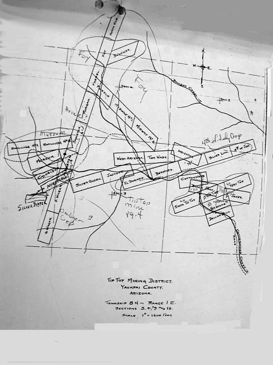
Source: State of Arizona Department of
Mines & Mineral Resources
The company hauled and packed in light machinery and began development work. In the following year a mill was built on the Agua Fria, eight miles from the mine, and there the town of Gillett sprang up. It was named for D. B. Gillett, superintendent of the Tip Top Mine, In October, 1878, Gillett became a Post Office with John J. Hill the postmaster.
For a time the silver ore was packed on burros from the Tip Top to the top of the Cottonwood Divide and hauled from there to Gillett by wagon.
Gillett was on the Prescott-Phoenix stage route and at one time had three saloons, a hotel, store, blacksmith shop and feed stable.
Gillett, AZ and Mill - Picture
Picture, Gillett, AZ - Source: Sharlot Hall Museum – Enhanced by Neal
Du Shane
In 1885 the San Francisco company sold the Tip Top to the St. Louis and Yavapai Mining Company, which concern built the road all the way in to the mine and also moved the mill to the mine, almost depopulating Gillett.
The St. Louis Company ceased operations in 1888 when the ore at the 830-foot level would no longer pay. However, they leased part of the ground to Bill Herman, Gus Bauer, Anton Berchamp and Dan Wright, who took out about $80,000 and then quit.
At the height of its glory Tip Top had a population of about 1,200 with six saloons, three stores, four restaurants, laundries and other enterprises, among which was a brewery operated by Peter Arnold, a German.
Tip Top Downtown Map (close-up)
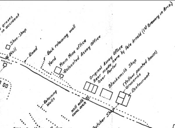
Business district Tip Top, AZ – Source: Sharlot Hall Museum, Inverted -
Enhance: Neal Du Shane
As development at the Tip Top, Museum, the Land other miners got under way, a number of families moved into camp. Among them were the Wager brothers and the Morgan’s. Ed Wager operated a store and became the second postmaster; George Wager was elected justice of the peace and Henry Wager, constable.
Oscar Wager, a son of George Wager, who spent the earlier years of his life at Tip Top and supplied most of the information for this article, not only saw the development of the camp but recalled many of the old characters who came there.
There was Jim Land who discovered and sold the Lane Mine for a fortune, blew the money in a short time on whisky and such stunts as buying a “personal performance” in a San Francisco theater and who later became insane.
Probably the most unforgettable character to the Tip Toppers was Louis Fell, a merchant who kept much of the miners’ money in his safe. He left camp one day on horseback “to meet his freight wagons” and never cam back. It was soon discovered that much of the miners’ savings went with him.
In the late 1880’s and early 1890’s the rich ores of the Tip Top District began to fade out and by the turn of the century only a few old prospectors remained in the hills. The writer visited the camp in 1903 when it was practically a ghost camp.
Jack Moore, one of the discoverers of the Tip Top, finally got his bath in the Castle Hot Spring. In 1885, he was found dead in a shallow pool there. In his pocket was 15 cents. There is no record of what became of his partner, Bill Corning.
Provided by: State of Arizona Department
of Mines & Mineral Resources
TIP TOP & MINE, SEVENTY-SIX MINE
Tip Top Mine was founded in 1875 and approximately 200 people are believed to have resided in the mining camp. There were several stores, a restaurant, a laundry and a saloon. A town called Gillett, on the Rio Agua Fria, now also classified as a ghost town, sprang up approximately 7 miles east of Tip Top to support the mine operations of both mines.
Directions to Gillett and Tip Top
North on I-17. Exit at Table Mesa Rd. Take a left over the freeway.
Turn right(north) on frontage Rd. Set trip meter to 0.00 when the road
turns to dirt.
1.1 miles stay right
1.8 miles stay right
3.9 miles Agua Fria River, continue across.
4.0 miles Take a right turn.
4.1 miles take right into Gillett.
4.3 miles Gillett N 34* 01' 07.5" W 112* 09' 49.3"
Take the same road out you came in on and turn right. When you get back
to the road you turned off of reset your trip meter to 0.00. 0.9 miles
up the road there is a wash on the right where you can put your vehicle
to a test of extreme 4wheeling.
0.9 miles wash to right
2.6 miles take a left at the corral N 34* 02' 05.1" W 112* 11' 36.6"
4.2 miles rest area great views to the east
5.3 miles Cross Cottonwood Creek. N 34* 01' 39.6" W
112*13'37.4"
7.6 miles collapsed building on the right
7.7 Brewery on the left N 34* 03' 3.2" W 112* 14' 49.7"
TIP TOP, ARIZONA
Gillett and Tip Top are linked together as mill and mine. The ore was mined at Tip Top and then shipped by wagon to Gillett for processing until a mill was erected at Tip Top in 1886. Gillett was also a stop over for the stage coach to Prescott.
The Tip Top Mine was discovered in 1875 and a Post Office was established there in 1880 and closed in 1895. Gillett was founded a few years later in 1878 with the Post Office being established in the same year. But with the building of the mill at Tip Top in 1886, the Post Office closed a year later. The hotel and saloon continued on for a few more years. The remains of the Burfind Hotel can still be seen today at what remains of Gillett.
Both towns are located on the Black Canyon City topo map. Take I-17 north to Table Mesa Rd. Get off at Table Mesa Rd. and take a left over the freeway. Take a right on the frontage rd. Set your trip meter to 0.00 when the road changes to dirt. If you are using a GPS receiver set your map datum to WGS84
1.1 miles Stay to the right.

1.8 miles Stay to the right.
3.9 miles Agua Fria River, continue across.
4.0 miles Turn right.
4.1 miles Take the first right.
You are in Gillett N 34* 01' 07.5" W 112* 09' 49.3" Take the same road out you came in on and turn right. When you get back to the road you turned off of reset your trip meter to 0.00. 0.9 miles up the road there is a wash on the right where you can put your vehicle to a test of extreme 4wheeling.

2.6 miles Take a left at the corral. N 34* 02' 05.1" W 112* 11' 36.6"
4.2 miles Rest area. Great views to the east.
5.3 miles Cross Cottonwood Creek. Road coming in from the left is an alternate route into Tip Top.N 34* 01' 39.6" W 112*13'37.4"
7.6 miles Tip Top
7.7 miles Building on the left believed to be the brewery. N 34* 03' 03.2" W 112* 14' 49.7"
A description of Tip Top from the Phoenix Hearld dated 6/4/1880 is as follows: "As I haven't any news of any importance I though I would drop you a note of the town and things in general. The town contains 2 stores of merchandise, 2 stores selling fruit, 6 fashionable saloons, 1 very nice restaurant, 1 splendid boarding house, can accommodate six hundred people, 1 livery stable in style, 1 butcher shop, 1 blacksmith shop, 1 Post Office, 2 bath houses, 1 barber shop and 3 laundries".
You can turn around from here when you are done exploring or you can continue up the road to another site I call Beyond Tip Top, but that is for another page.
---------------------------------------------------------------------------------------------------------------------
Tip
Top! - Arizona Ghost Towns
by Mark Quigley, feature for The Arizona Sportsman's
Journal TV (www.azho.com)
Courtesy of Mark Quigley
Last time we talked about Gillett, so I thought this time I would take you on an adventure over the old wagon haul road that led from Gillett into the rugged Bradshaw Mountains. This trip will require a 4-wheel drive vehicle in good condition. Be for-warned it’s a rough road adventure that should only be taken in cool months

Tip Top, Az - Tip Top’s mill and
mining office, below right. Ore car rail tracks were built throughout the town.
- Photo courtesy of Sharlot Hall Museum.
If planning to visit Gillett, you should also plan to stop at the ghost town of Tip Top. This was another very busy and crowded town, boasting a population of 1,200 people, the largest mining town in central Arizona. Named for a “tip top” silver prospect, this town boasted two hotels, two general stores, gin mills, six saloons, a Chinese laundry, butcher shop, stables/feed yard, two restaurants, blacksmith shop, Post Office, school, brothel, stage line to Prescott and even a shoe store. The town also had a Courthouse where Constable Joe Walker presided. Tip Top extended along Cottonwood Creek for three miles. Most of the businesses lined the creek below the Tip Top Mine. Another downtown area, located above the gulch, consisted of a hotel and stores paralleling Grapevine Springs, the town’s water supply. At first, a mill was erected nine miles away, at Gillett. Wagon freight trains with 12 to 16 mules made daily trips through the mountains hauling silver to Gillett. Later, Tip Top built its own silver mill, and between 1878 to 1883 milled $1.5 million in silver.
Many of Tip Top’s miners were veterans of the Civil War, both Union and Confederate. They got along well, even though everyone wore handguns because of the renegade Indians raiding in the area. A few killings were recorded during Tip Top’s history. Two people were killed in gunfights, another by lightning and a fourth by a centipede bite. As the centipede story goes, a miner arose early one morning and while putting on his boots was bitten on the toe by centipede. Not knowing what to do, he rushed to the closest saloon and gulped down a quart of whiskey. Townspeople were not sure if he died from the whiskey or the bite.
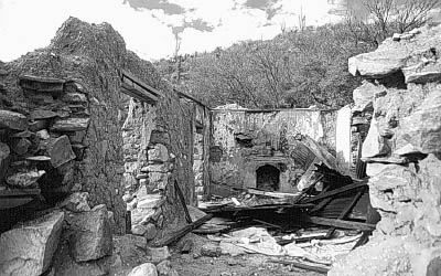
Tip Top, Az - The old Brewery at Tip
Top made strong drink for its 1,200 residents.
The roof gave in a few years ago. - Mr. Quigley Photography
Later, an old newspaper account stated that, “A good rain is needed badly in Tip Top to wash out the gulch, as the accumulation of filth is getting so strong that one can scarcely pass up the street.”
Tip Toppers were known for their gambling and drinking.
One lucky gambler made $9,700 in one week. Gamblers from all over Arizona
traveled to the town and on the sixth of each month (payday for miners) would
be waiting patiently in the many saloons for the naive miners. On many occasions, there
were dances in the streets of Tip Top on pay day. Once, a minister from Phoenix came to Tip Top. With no church in town, he
held services under a big cottonwood tree. All the townspeople came to hear
him, sitting under the tree, drinking beer and thoroughly enjoying the sermon.
When the federal government demonetized silver in 1893, Tip Top’s silver mines became worthless. Overnight Tip Top became a ghost town as miners moved on to gold strikes farther up in the Bradshaw Mountains. In 1910, after tungsten was discovered at the mines, they had a short-lived revival.
Tip Top today is a quiet, abandoned ghost town. The mines and several stone buildings (brewery, restaurant and beer hall) still remain. Other stone homes and business are scattered over three miles around Tip Top. The foundations of the silver stamp mills, mining office and several other buildings all remain above the town. Tip Top’s mines are impressive and worth a careful visit. The many roads leading from the mines are actually a system of elaborate ore cart tracks. The graveyard lies upstream about .5 miles below the Seventy-Six Mine on the north bank of Cottonwood Creek. It has more than 20 graves, with several small ones, probably children’s.
Tip Top, Az - Old silver mill site at Tip Top.
The road can be seen in the background.
- Mr. Quigley Photography
The road to Tip Top requires four-wheel drive vehicles. It is a beautiful trip through canyons, creeks and ridges, decorated with saguaro and mesquite forests. From Gillett, travel west on the old Gillett road. This is the original wagon road over which silver was transported to Gillett for smelting. A little over three miles later you will come to a corral, make a left here and follow this road to Williams Mesa. Once on top you will have spectacular views of Cottonwood Creek to the west and the New River Mountains to the east. Off the west side of Williams Mesa, a rough road will take you down to Boulder Creek. This is a rocky, nasty road, so take your time. It’s hard to believe that heavily loaded wagons once used this route. Once at the bottom, in Boulder Creek, you come to a ‘T’ in the road; turn right. At this point, when you are on your way out, you can continue down Boulder Creek, instead of turning east and climbing the mountain back to Gillett. This road follows Boulder Creek and will eventually take you to the end of Lake Pleasant, (Agua Fria channel). You will pass the site of the old ranch home, originally part of the Boulder Creek Ranch. At Lake Pleasant, follow Table Mesa Road back to Interstate 17.
Tip Top, Az - Mine at Tip Top. - .Mr.
Quigley Photography
Now back to the ‘T’ in the road; follow this rough road for about another three miles before entering Tip Top. Exploring Tip Top is best done on foot, as the roads leading to the mines are in terrible shape and hard to turn around on. After exploring Tip Top, you can travel west again on the Tip Top road, which will eventually take you to the ghost camp of Packer, (an old pack-mule-train stopping point on the way to Crown King) and finally on to Crown King, (Horse Thief Basin). The last time I went this way, I had to use an ATV to get to Crown King. I strongly recommend you do not travel this way by yourself, but rather in a group. The road that leads to Crown King is in extremely poor condition and can be a dangerous, as well as a long trip. There are several other roads west of Tip Top that lead to other mines. You can also follow a poor four-wheel-drive road to Columbia another ghost town that I will write about later. Travel safe, courteous & leave no trace.
Comment on this article, share your ghost town experiences or just post your pictures.
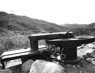
Tip Top, Az - Some old heavy equipment rements.Mr. Quigley Photography
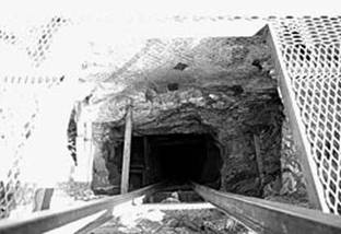
Tip Top, Az - Looking straight down the shaft of one of Tip Top’s deep mines. - Mr. Quigley Photography
-----------------------------------------------------------------------------------------------------
76 Mine, Tip Top District, Bradshaw Mts (Bradshaw Range), Yavapai Co., Arizona, USA
‡Ref.: The Resources of Arizona - A Manual of Reliable Information Concerning the Territory, compiled by Patrick Hamilton (1881), Scottsdale, AZ: 52; Anthony, J.W., et al (1995),
Mineralogy of Arizona, 3rd.ed.: 382; Lindgren, W. (1926),
USGS Bull. 782: 28, 182; Galbraith, F.W. (1947), Minerals of AZ, AZ Bur. of
Mines Bull. 153: 22.
A mine located about ½ mile above the Tip Top Mine.
Mineralogy is the 76 vein, which is very similar to the Tip Top Vein. Reopened in 1922.
Workings include 3 tunnels at 200, 120 & 85 feet long, respectively.
The Tip Top Mine was founded in 1875 and about 200 people are said to have populated the mining camp. There were several stores, a restaurant, a laundry and a saloon. A town called Gillett, now also classified as a ghost town, sprang up nearby Tip Top to support the mine operations.
Tip – Top or Drop
By: Neal Du Shane
March 31, 2006 – found me having postponed this sojourn three days this week due to rain – of which only one day rained. Decided to try and see if I could reach Tip Top as I was somewhat reluctant after reading about the road leading to it.
Took the Honda XR650L and unloaded at the Table Mesa Road exit at the end of the blacktop on the west side of the frontage road. Fairly well traveled, as there is a stone quarry that trucks are hauling rocks out of a little farther down the road.
Headed west and forded the Rio Agua Fria, stopped off at Gillett to explore once more, to see if there was anything we missed on the previous two trips here. Got on a few new roads but nothing exciting as was our first two trips.
Followed the road west for approximately 5.2 miles. Reaching a wyes in the road I double-checked the GPS to my map and veered right, headed up Boulder Creek and the main road for approximately 2.5 to 3 miles. Started seeing little signs of stone walls, foundations then all of a sudden I was at the outskirts of Tip Top.
There are still several stonewalls of business’s remaining on the left side of the road. Just before reaching Tip Top another road leads you off to the right and it climbs up to the Tip Top Mine with an impressive view of the valley and buildings of the ghost town of Tip Top.
Explored the buildings and took pictures then headed west to see if I could find the Tip Top Cemetery. Supposedly it is between the Seventy-Six Mine and the Tip Top Mine. Stopping several times to take pictures, explore and look for a flat area where a cemetery might have been. About ½ to ¾ mile past the stone buildings in Tip Top I come to a creek crossing on the left, you will see a dilapidated windmill on the far bank of the creek. I crossed the creek at this point and explored this flat area. Sure enough I found 4 or 5 rock enclosures that upon dowsing indicated male interments. Walked the approximately 30’ X 150’ area approximately 200’ south of the windmill and dowsing detected 15 to 20 burials all male.
Tip Top Cemetery
The main vandals to this cemetery are cattle; meadow muffins were everywhere, to the point you had to be careful where you stepped. While it can be reasoned humans have done their fair share, today cattle are the main culprits. This is an excellent example of why you shouldn’t put a livestock-watering tank near an unfenced cemetery. Further research may reveal headstones?
I got to reasoning, just how many actual stone headstones could there have been here? Most of those interred here were single miners, without family in the area and doubt they would have the financial ability to arrange for a marble or granite headstone. Let alone make arrangements and transportation to get it up here. Although Rusty Hastings and Ed Foust indicate they remember seeing headstones here some years ago. Regardless, there is no evidence of headstones remaining; only several stacks of rocks the size of a burial and most not marked at all. It’s evident the cattle are scattering the remaining evidence and will continue to do so unless some type of fence enclosure is put up. It has been discovered in addition to the Tip Top Cemetery there are three miners buried at the south end of Tip Top. Slightly north of the mine road leading to the right up to the mine. Two individuals were shot, and one poor miner, while putting on his boots one morning was bitten by a centipede inside the boot. The hapless miner went directly to the saloon and consumed considerable amount of whisky. No one is sure if the centipede or the whisky did him in, regardless his is buried in the Tip Top Cemetery.
Since my first trip to Tip Top I discovered there are a total of three burial locations in Tip Top. There is one location of three miners killed in a mine accident and buried at the SE end of Tip Top. Little else is known about any of the individuals buried at either Tip Top location. The second location is on the road to the right just after crossing the creek at the SE end of town. Traverse up this road a short distance and you will come to a curve to the right, within a block on your right is a flat plateau where it’s believed a man, a child and an unknown person is interred. The last is the main Tip Top Cemetery and is on the same side of the creek as the windmill. If you have any information or names relating to either of these locations, I would be very interested in logging it for genealogical purposes and research information.
Tip Top Cemeteries (3) List of Interments
|
TIP TOP CEMETERY |
||||||
|
|
|
|
|
|
|
|
|
Yavapai County, Arizona |
||||||
|
|
|
|
|
|
|
|
|
Ghost Town of Tip Top, Arizona |
||||||
|
|
|
|
|
|
|
|
|
Latitude N34 03.069, Longitude W112 15.294
- (Elevation 2,589) |
||||||
|
|
|
|
|
|
|
|
|
There
are three known burial sites at Tip Top. 1). 3 miners graves are at the SE end of
town as you enter. 2). A man, Child and unknown are on the hill on the road
up to the mine. 3). The Tip Top Cemetery lies upstream from the Ghost Town -
and approx .5 miles below (SE) the Seventy-Six Mine on the S. bank of
Cottonwood Creek. The main Tip Top Cemetery has more than 20 graves, with
several young children. |
||||||
|
|
|
|
|
|
|
|
|
|
Burials = |
21 |
|
|
|
6/7/2006 |
|
Marker |
SURNAME |
FIRST NAME |
MIDDLE NAME |
BIRTH DATE |
DEATH DATE |
COMMENTS |
|
|
|
|
|
|
|
|
|
N |
DOE |
Jane |
|
|
|
Unmarked
interment |
|
N |
DOE |
Jane |
|
|
|
Unmarked
interment |
|
N |
DOE |
Jane |
|
|
|
Unmarked
interment |
|
N |
DOE |
Jane |
|
|
|
Unmarked
interment |
|
N |
DOE |
Jane |
|
|
|
Unmarked
interment |
|
N |
DOE |
Jane |
|
|
|
Unmarked
interment |
|
N |
DOE |
John |
|
|
|
Unmarked
interment - Killed in Gun Fight |
|
N |
DOE |
John |
|
|
|
Unmarked
interment |
|
N |
DOE |
John |
|
|
|
Unmarked
interment |
|
N |
DOE |
John |
|
|
|
Unmarked
interment |
|
N |
DOE |
John |
|
|
|
Unmarked
interment - Killed in Gun Fight |
|
N |
DOE |
John |
|
|
|
Unmarked
interment |
|
N |
DOE |
John |
|
|
|
Unmarked
interment |
|
N |
DOE |
John |
|
|
|
Unmarked
interment |
|
N |
DOE |
John |
|
|
|
Unmarked
interment - Struck by lightning |
|
N |
DOE |
John |
|
|
|
Unmarked
interment |
|
N |
DOE |
John |
|
|
|
Unmarked
interment |
|
N |
DOE |
John |
|
|
|
Unmarked
interment - bit by centipede |
|
N |
DOE |
John |
|
|
|
Unmarked
interment |
|
N |
DOE |
John |
|
|
|
Unmarked
interment |
|
N |
DOE |
John |
|
|
|
Unmarked
interment |
|
|
|
|
|
|
|
|
|
0 |
21 |
|
|
|
|
|
|
3 MINERS GRAVES |
||||||
|
Latitude N34 02.92, Longitude W 112 14.806
(Elevation 2,497) |
||||||
|
|
Burials = |
3 |
|
|
|
|
|
Marker |
SURNAME |
FIRST NAME |
MIDDLE |
BIRTH DATE |
DEATH DATE |
COMMENTS |
|
Y |
DOE |
John |
|
|
|
Killed
in mine accident |
|
N |
DOE |
John |
|
|
|
Killed
in mine accident |
|
N |
DOE |
John |
|
|
|
Killed
in mine accident |
|
|
|
|
|
|
|
|
|
|
|
|
|
|
|
|
|
MAN, CHILD AND UNKNOWN
GRAVES |
||||||
|
(NOT VERIFIED) Latitude N34 02.938,
Longitude W112 14.660 (Elevation 2,655) |
||||||
|
|
Burials = |
3 |
|
|
|
|
|
Marker |
SURNAME |
FIRST NAME |
MIDDLE |
BIRTH DATE |
DEATH DATE |
COMMENTS |
|
N |
DOE |
John |
|
|
|
Man |
|
N |
DOE |
? |
|
|
|
Child |
|
N |
DOE |
? |
|
|
|
Unknown |
|
|
|
|
|
|
|
|
|
Research by: |
Neal Du Shane |
|
|
|
||
|
|
|
|
|
|
|
|
|
Contributor: Neal Du Shane: 3/31/06 Research of the general area
found all male interments. No headstones were found. Some rock stacking
indicating burials. |
||||||
|
|
|
|
|
|
|
|
|
Material may be freely
used in it's exact format and cannot be changed or altered, |
||||||
|
by non-commercial
entities, as long as this message remains on all copied material, |
||||||
|
AND written
permission is obtained from the contributor of the file. |
||||||
|
|
|
|
|
|
|
|
|
These electronic
pages are presented by AZGenWeb and
may NOT be reproduced, in any |
||||||
|
format for profit
or presentation by other organizations. Persons or organizations |
||||||
|
desiring to use this
material for non-commercial purposes, MUST obtain |
||||||
|
the written
consent of the contributor, OR the legal representative of |
||||||
|
the contributor,
and contact the archivist with proof of this consent. |
||||||
|
|
|
|
|
|
|
|
|
This file was contributed exclusively at no
charge and free from any charge. |
||||||
|
Contributor/Archives by: Neal Du Shane -
All rights reserved © |
||||||
Decided to explore farther to the Northwest and find the Seventy-Six Mine. Continued traveling west to the junction in the road approximately another mile, right took me to Parker then to Crown King. Road to the left takes you to Columbia. At this junction in the road there is someone living here – talk about remote. Never saw anyone (I’m sure they saw me!) and the Bloodhound was barking at the encampment. Don’t know if this is a ranch line camp or a left over from the Boom days at Tip Top or the 60’s?
Dah road boss . . . Dah road! – its far from the worst road I’ve been on this year (Crown King Trail is at the top of my worst list, at this time) but it is definitely four-wheel drive in several spots. Not impassable but granny gear with high clearance will certainly make this trip more enjoyable. This was a fun trip and on the motorcycle, it took me about three hours up and back and researching the area. In total I put on 35 miles round trip from where I parked the vehicle. This is definitely a trip worth the effort. Plus explore the side roads once you get to the Tip Top area.
Tip Top Cemetery: Latitude N 34 03.069, Longitude W 112 15.294
Miners Burials (3): Latitude N 34 2.920, Longitude W 112 14.806
Three Burials (3): Latitude N 34 02.938 Longitude W 112 14.660
Tip Top Business: Latitude N 34 03.061, Longitude W 112 14.825
Newt White at Tip Top
Newt is known to have worked and socialized in various locations in the Southern Bradshaw’s from Champie Ranch to Cordes. He was well liked, amenable and seemed to adapt to various jobs from Cowboy, Cook, Security Guard, Mayor to Miner. Dave Burns relates a couple of instances that Newt told him about working in the Tip Top Mine District.
“Newt worked with the cyanide process there. I think they were removing pillars in the mine and reprocessing tailings. He talked about going in the mine when they were pumping out the water. When it came time to shut the mine down, he had noticed that the tank rakes wouldn't go all the way down, and measured the depth of the solution.
Turned out there was a substantial buildup of concentrates
in the bottom of the tanks. They tested very rich. A final big
profit was made by cutting holes in the bottoms of the tanks and removing the
concentrates. I always wondered if he had kept his mouth shut he could
have come back later and got rich. Guess that just wasn't his way.
Newt must have worked occasionally as cook. He told about when the game
warden stopped by one day. Newt was cutting the tops off carrots, tossing
them out the back door, while talking with the warden. The warden looked
out the door and saw a deer eating the tops. "Guess there isn't much
poaching going on around here," said the warden.”
John Henry Cordes
When John first came to Arizona, he worked at the Tip Top District for a couple of years in the 1880’s. Then went north and purchased land then developed Cordes, AZ. (Not to be confused with Cordes Junction).
Doc Holiday and Big Nose Kate
Doc and Kate were among the dignitary visitors to Tip Top. Stopping only for a night or two on their way from/to Phoenix and or Crown King. It is written that the saloon keeper in Tip Top was a cantankerous sort. The stagecoach would stop and overnight in Tip Top at this saloon, on its way to and from Crown King/Phoenix. Normally the saloon keeper would not allow passengers to sleep overnight in the building and they would have to sleep in the stagecoach. When Doc and Kate came through Tip Top and stayed overnight, there was room for them inside and they reportedly enjoyed their stay. Very likely an astute decision on the saloon keeper’s part to allow Doc and Kate to stay inside. There is speculation on my part there may have been an addition to one of the three cemeteries in Tip Top if they were told to sleep in the stagecoach.
A special thank you, to all that contributed, making this possible:
Rusty & Betty Hastings, State of
WebMaster: Neal Du Shane
0225507
Copyright
©2003-2007 Neal Du Shane
All rights reserved. Information contained within this website may be
used
for personal family history purposes, but not for financial profit of any
kind.
All contents of this website are willed to the
HOME | BOOSTER | CEMETERIES | EDUCATION
| GHOST TOWNS
| HEADSTONE
MINOTTO |PICTURES | ROADS | JACK SWILLING | TEN DAY TRAMPS