HOME | BOOSTER | CEMETERIES | EDUCATION | GHOST TOWNS | HEADSTONE
MINOTTO | PICTURES | ROADS | JACK SWILLING | TEN DAY TRAMPS
American
Pioneer & Cemetery
Research Project
Internet Publication
Version 102509-AH
Lost in Plain Sight – The Senator Mine
By: Allan Hall - APCRP Certified Coordinator
I received a research request from Neal
the other day to help pin down the location of the Senator Mine in the Bradshaw
Mountains. The question in his note was
pretty straight forward:
“Any
idea where Maxton or the Senator Mine was at the head of the Hassayampa?
There is a Senator Mine up near Prescott (south) which would make logical sense
as the Hassayampa Head is up there. But I can’t find info on Maxton.”
According
to Neal’s reference source the following clue was provided:
“The next and third stop on the long road was Buck Horn Station, a
saloon where teamsters and miners could again wash the dust from their throats
and proceed on to the fourth and final night stop, a place called Maxton, at
the head of the Hassayampa River, where the famous Senator Mine was located.”
It has always puzzled me why a mine as
famous as the Senator was not named on USGS maps. I had seen vague references to the Senator’s
location before on the usual authoritative sites, but had not followed up on
them. By “authoritative,” I include the
esteemed web sites of Mindat.org and, of course, the USGS. Mindat provides the following set of
coordinates for the mine: N 34o
24’ 58” by W 112o 24’ 40”.
When these are entered into mapping software the result is a location on
the northwest shoulder of Mt. Union, about 200 feet from the symbol for an
unnamed mine adit. Not exactly a bull’s
eye, but not bad. However, if you used
those coordinates as the sole basis for an outing, you would be mistaken and
possibly disappointed.
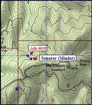
Map 1, Mindat Coordinates for
Senator Mine
The issue here – and perhaps an important
one for researching places of historical importance – is that Mindat is
attempting to use a single set of coordinates to represent the location of the “Senator
Mine” when it is actually four mines with an unspecified number of workings and
prospects. To be truthful, neither
Mindat nor (apparently) the USGS really knows which particular hole in the
ground was the original Senator Mine.
A Bit of History
The Senator Mine was famously known as a gold
property, but its primary production was lead and zinc, with lesser amounts of silver
and copper. It began operation some time
before 1871. By 1881 the Senator Shaft had reached 200 feet in depth with
multiple levels, drifts and crosscuts.
For a period of about two years mining operations apparently stopped and
it then reopened from 1883 until 1899.
During this second period the shaft was sunk to its maximum depth of 835
feet. There was a 250 foot long stope on
the 600 foot level of the mine. Additional
activity occurred, possibly on an intermittent basis, until at least 1934.
The mine was situated on what became
known as the Senator Vein and was a patented claim. The immediate vicinity had three other veins
however, and these too were patented as the Snoozer, Ten Spot and Tredwell
claims. Although there may have been one
or more adits, the four mines utilized shafts as the principal method to reach
the veins. Knowing that the Senator Mine
was a shaft operation, the Mindat coordinate raised an immediate question about
its accuracy.
If you are familiar with the use of Section,
Township and Range as a means of describing a location you know that mine
claims (and even the legal description of your property) use terminology such
as “SE ¼ Section 36, T3S, R23W.” Although its use can be a bit frustrating and
may seem anachronistic compared to GPS coordinates, they are usually very
useful when trying to sort out one old mine from another where there was dense
mining activity.
For example, the location of the Senator
Mine group is defined as having claims “that extend into” Section 2 and Section
35, T12N, R2W. Importantly, saying that some
portion of the claims are in these Sections does not
mean that the shafts are located there.
It does mean, however, that the claims gave the owners the right to
pursue the ore veins by surface or underground means if they wanted. See Map 2 below.
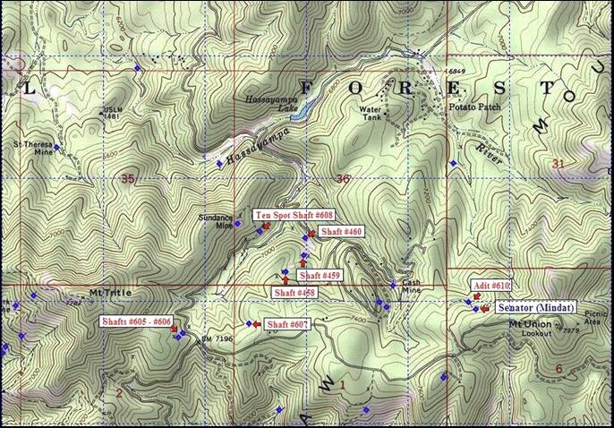
Map 2, Expanded View of Senator
Mine Area
In this map view you can see the Mindat location
and the unnamed adit in the lower right corner (NW ¼ of Section 6). The left portion of the map shows Sections 2
and 35, which are claim areas of the Senator, Snoozer, Ten Spot and Tredwell veins. As you can see, most of the mine workings are
quite some distance from the location provided by Mindat,
and Section 35 is virtually empty of mine entrances.
The Cash Mine straddles the boundary
between Sections 1 and 36. The Cash Mine
began operations some time before 1881 but after the Senator Mine. By the time the Senator shaft had reached 200
feet the Cash shaft was only 28 feet deep.
The patented claims of the Cash Mine extend into Sections 1 and 2. This means that the three shafts (#605, #606
and #607)) in these Sections are part of the Cash Mine and are not related to
the Senator Mine group. That leaves four
candidate shafts in Section 36, but none of them are named on USGS maps.
Fortunately, there is an excellent set of
coordinates that positively identify the Ten Spot Shaft (here numbered #608)
residing in the southwest quarter of Section 36. The Ten Spot vein was not as rich as the
Senator. Although the mine extracted
some silver, gold, copper and lead, its production was limited to a single year
– 1932. I can find no information
regarding the depth of the Ten Spot shaft or the nature and extent of
underground workings.
We are left, by process of elimination,
with three shafts (#458, #459 and #460) to resolve the mystery location of the
Senator Mine. To be honest, I have no idea which of these is the Senator,
Snoozer or Tredwell. That may be as close as we will ever come to knowing.
The records do say that a ten stamp mill
was built for the Senator Mine “one mile distant on Hassayampa Creek.” The mill would have been somewhere in the
upper portion of Section 36 between what is today Hassayampa Lake and Potato
Patch. The reference to the Hassayampa
helps confirm that the three shafts are valid candidates for the Senator Mine.
Establishing a precise location for Maxton might help to resolve the question. Was Maxton the original name of Potato Patch,
or was Maxton the name of the mill site?
Bobbi Wicks adds:
American
Pioneer & Cemetery
Research Project
Internet Publication
Version 102509-AH
WebMaster: Neal Du Shane
Copyright © 2009
Neal Du Shane
All rights reserved. Information contained within this
website may be used
for personal family history purposes, but not for financial profit or gain.
All contents of this website are willed to the American Pioneer & Cemetery
Research Project (APCRP).
HOME | BOOSTER | CEMETERIES | EDUCATION | GHOST TOWNS | HEADSTONE
MINOTTO | PICTURES | ROADS | JACK SWILLING | TEN DAY TRAMPS