HOME | BOOSTER | CEMETERIES | EDUCATION | GHOST TOWNS | HEADSTONE
MINOTTO | PICTURES | ROADS | JACK SWILLING | TEN DAY TRAMPS
American
Pioneer & Cemetery
Research Project
Internet Presentation
Version 031409

By Kathy Block,
APCRP Coordinator, Historian
THERE SITS, amid a barren, rocky plain just west of the
boundary of the Yuma Army Proving Ground, a forlorn little cemetery. It lies to
the right of Martinez Lake Road that goes west to Fishers Landing, Martinez
Lake and Martinez Lake Resort and Imperial Wildlife Refuge Headquarters from
Highway 95 at milepost 46, north of Yuma. The site is located down a steep
embankment, and as one drives by, there are brief glimpses of a little monument
with a brass plaque, surrounded by some lumps of dirt and stone with fading
plastic flowers on them. Why is this cemetery here? Who is buried here?
|
|
|
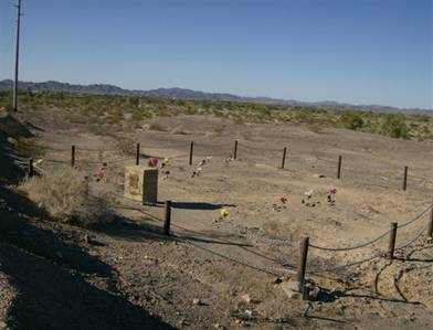
Photo’s by: Ed Block
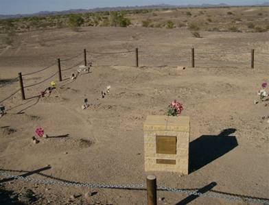
Closer inspection of the brass plaque (reached by a perilous
slide down the bank) shows this information: A list of names, all but one
"John Doe". The only name is "Antonio Preciado (Adult)." The
dates of burials are 1899. The Yuma Reel & Rod Club of Yuma erected
this monument and plaque in 1977. Inquiries to this group were not answered.
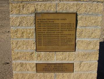
Photo by: Ed Block
Finally, an e-mail to the Imperial National Wildlife Refuge
elicited some answers from Denise Bausch, Visitor Services Manager, Imperial
National Wildlife Refuge. She wrote:
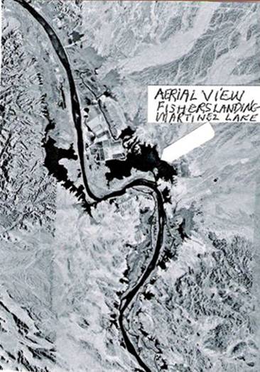
"In the 1800s a Hispanic family came up river on a
steamboat and settled at what is now Fisher's Landing. They all died in a
Small Pox epidemic and were buried on an island in the lake. When
Imperial Dam was to be built, O.C. Johnson Mortuary dug up the remains and
moved them to the cemetery. I believe the original island was inundated when
the Dam was built. The cemetery is now maintained by the Women's Club.
Unfortunately, that is all the information I have at this time."
History of the Imperial Dam project reveals a massive
rebuilding and displacement of the land and people living along the Colorado
River. The Colorado River was a waterway of major commercial importance
in the late 1800s and was plied by steam ships from the mouth of the river at
the Sea of Cortez all the way up to the Mojave area, a distance of over 250
miles. The level and flow fluctuated dramatically with the snow pack and snow
melt and could be a raging current in the spring and a mere trickle in the
winter. A look at historic landing sites, such as Castle Dome Landing
just downriver from present day Fishers Landing, and Hardyville upriver (see, www.APCRP.org),
showed considerable economic dependence of these areas on the river traffic. As
railroads developed in the late 1880s, the river lost its importance as a
waterway. Attention turned to the use of the river water for irrigation
and flood control in areas north of Yuma and in the Imperial Valley of
California.
A massive system of dams and canals was constructed in the
1930s, known collectively as the Imperial Dam Project. As a result, the
Colorado River is the most utilized river in the world relative to irrigation,
human consumption, and the creation of power. The river and its drainage
encompass some 8 % of the TOTAL area of the United States.
The beginnings of this project were in California. In
the 1850s the California legislature proposed development and irrigation of the
Imperial Valley, using water from the Colorado River. Various irrigation
companies and districts were unsuccessfully formed in the late 1890s. Various
Reclamation Acts of Congress were passed, and the Boulder Canyon Act of 1928
provided for construction of Hoover Dam and a main canal connecting Laguna Dam
(north of Yuma) with Imperial and Coachella Valleys in Southern
California.
A diversion dam was funded in 1932 and also the All-American
Canal was planned. During the Depression, labor was hired from unemployed
farmers and others, numbering 250 men and 1,000 head of horses and mules.
Workers for the Reclamation Project cleared plant life and mines and
settlements from the reservoir site for Imperial Dam, and possibly removed
other cemeteries besides this small Martinez Lake Road cemetery. Native
Americans were employed from the nearby Fort Yuma Indian Reservation to clear
sites using only hand tools! The Imperial Dam system was finished in
1938, having undergone major problems from flooding, leakage, and
earthquakes. Actual water began to back up in the spring of 1940, but an
earthquake destroyed some of the canal in May 1940. As the waters of Imperial
Dam began to fill the Colorado River basin upriver, many lakes were formed.
Martinez Lake, where Fishers Landing is located, was formed
as part of the Imperial Reservoir and Colorado River system. The Lake is 1/2
mile by 3/4 of a mile, immediately off the Colorado River 8 miles above the
Imperial Dam and 65 miles south of a Blythe diversion dam. Martinez Lake
Resort is on an original grazing lease parcel managed by the Martinez family
since 1920. It was the only piece of privately owned land between Ehrenberg
(another historic river site, see APCRP web site) to the Imperial Dam on the
Arizona side. The Resort began as a fishing camp in 1955 and expanded
over the past decades into a 150 acre site that includes stores, camping,
homesites, marinas, etc. A scenic jet boat tour can be taken up the river from
Fishers Landing, plus jeep tours to Kofa and its historic cemetery are offered
from the resort.
In early 1992 the BLM turned over 2,600 additional acres to
the Arizona State Land Commission and 113 homesites around Martinez Lake and
Fishers Landing were sold to the public. Today there are 141 privately owned
homesites in the area, with 112 waterfront and 29 interior sites. In addition,
a large portion of surrounding land is controlled by the Dept. of the Interior
for the Imperial National Wildlife Refuge along both the California and Arizona
sides of the Colorado River.
By Kathy
Block
The island where the unfortunate family was buried was
covered by this lake at Fishers Landing. The remains were removed, as
mentioned, by O.C. Johnson Mortunary of Yuma. The mortuary was founded in
1907 by O.C. Johnson, became the Johnson Mortuary and Desert Lawn Memorial Park
in 1937, and in 1987 relocated to the cemetery grounds. Early burial records
are held by the Geneological Society of Yuma in their Family History
Center. One can find information on burials at Laguna Cemetery (APCRP web
site), and other pioneer cemeteries in the Yuma area.
In conclusion, Imperial Dam project had great impact on the
land, historic settlements, and people, both living and dead, along the
Colorado River.
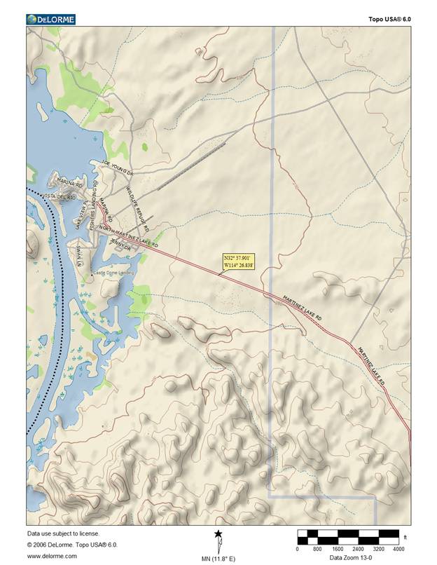
GPS reading of
Martinez Lake Road Cemetery. Map by: Neal Du Shane
American
Pioneer & Cemetery
Research Project
Internet Presentation
Version 031409
WebMaster: Neal Du Shane
Copyright © 2008 Neal Du Shane
All rights reserved.
Information contained within this website may be used
for personal family
history purposes, but not for financial profit.
All contents of this
website are willed to the American Pioneer & Cemetery Research Project (APCRP).
HOME | BOOSTER | CEMETERIES | EDUCATION | GHOST TOWNS | HEADSTONE
MINOTTO | PICTURES | ROADS | JACK SWILLING | TEN DAY TRAMPS