HOME | BOOSTER | CEMETERIES | EDUCATION
| GHOST TOWNS
| HEADSTONE
MINOTTO |PICTURES | ROADS | JACK SWILLING | TEN DAY TRAMPS
Presentation
Version 081722
Support APCRP: Click Here
Hardcopy book available:
$30.00 plus
$10.00 S & H
C
HUMBUG IS NO LONGER ACCESSIBLE DO TO PRIVATE LAND OWNER RESTRICTIONS.

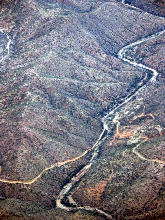
Photograph by:
Neal Du Shane, Pilot: Gary Grant
Compiled and edited by: Neal Du Shane 04/29/06 Revised
04/08/08
Internet Edition -
Volume Two
Version 040808
Copyright © 2008 by Neal Du Shane
No part of this book or Website page may be reproduced, stored in a retrieval system or transmitted in any form or by any means, electronic, mechanical, photocopying, recording or otherwise, without permission of the publisher.
Published by: Neal Du Shane, Fort Collins, CO 80525
Second Edition
Published in the
TABLE OF CONTENTS
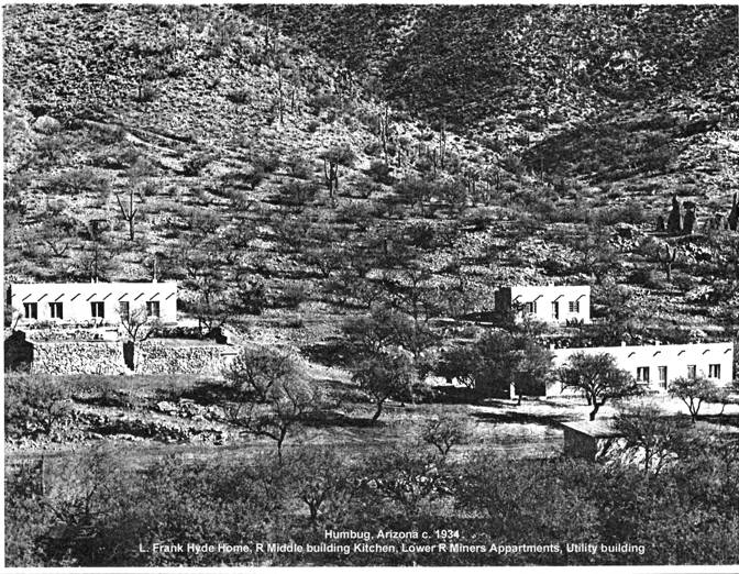
Humbug, Arizona -
c. 1934 - Picture
Sign posted at main gate leading to
Humbug, AZ
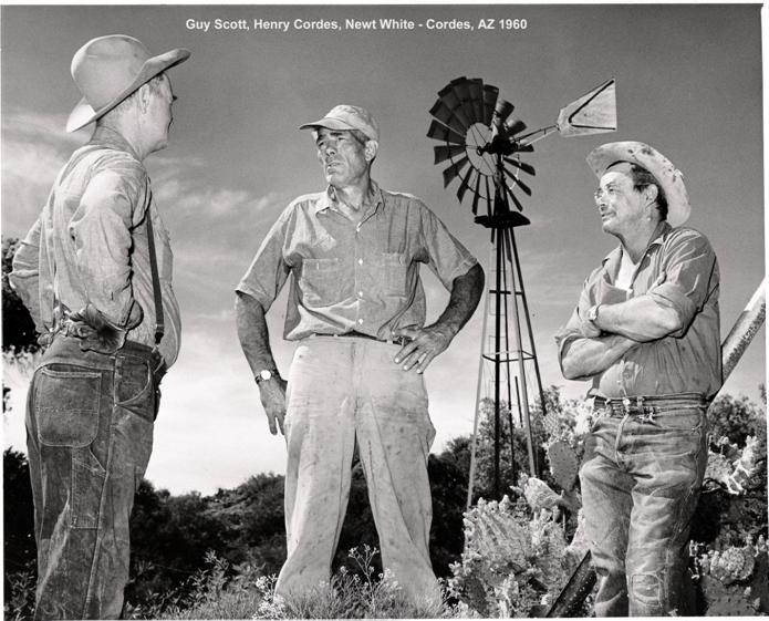
Picture of: Guy Scott, Henry Cordes,
Newt White
Newt Whites room at Cordes, AZ
Humbug, Arizona
A
HISTORY OF HUMBUG
By: Dave Burns, November, 2001
Prehistory
Small pottery shards and matate fragments indicate previous habitation by Native Americans, but most evidence is gone.
- 1882 -
Charles Champie and family arrived and began mining gold on the Llano Claim. He excavated a shaft and tunnel, built two stone houses, mill site, well, and smelting furnace. The Llano workings produced about 2,000 ounces of gold.
He then developed a tunnel on the Sidewinder Claim about a mile east, recovering about 1,000 ounces of gold.
On the Mountain Chief Claim (later renamed El Pero Bonito) south of the 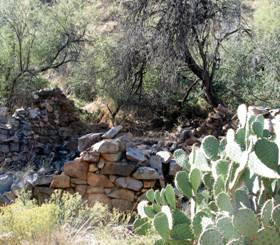 Sidewinder, a pocket produced 5,000
ounces of gold.
Sidewinder, a pocket produced 5,000
ounces of gold.
At this point, Champie & Co. left Humbug and moved about two miles south to
Charles Champie House Photo by: Neal Du Shane
- 1920 -
Pat Fogarty was living and mining at Humbug when Frank Hyde, a wealthy easterner, was looking to invest in gold mining. They struck a partnership, with Hyde supplying the operation with a substantial infusion of capital. He built half a dozen new buildings, including a large house for himself and his family, miner's quarters, mess hall, assay office, and a cottage for Pat Fogarty, who was getting old.
Hyde's mining operation produced about $50,000 in gold, silver, copper, and lead. This included a 1,000 oz gold pocket from the Little Annie Claim. Production was not sufficient to cover expenses, however, and mining was discontinued in 1934.
- 1940 -
Newt White came to work for Frank Hyde about 1940 after having worked many years for
the Champie Ranch and other jobs including miner, mill operator,
cowboy, wrangler, mechanic, etc. He stayed on at Humbug as caretaker after Hyde moved to
- 1970 -
Frank Hyde's daughter, Carolyn, formed a small corporation
called Humbug Gold, Inc. with equal stockholders
herself, Newt White, and Dr. Robert Hurt, a
Courtesy
HUMBUG
DISTRICT
Humbug Mines –
Acknowledgement are due M.J. Elsing, C.L. Orem and F. de L. Hyde of Humbug Gold
Mines, Inc., for important information.
Situation and
history: The holdings of Humbug
Gold Mines Inc., in the
southwestern
Larry Gill - 2006 at the old Arastra in
In this area, gold mining
was carried on with the aid of arastra’s as early as 1880. From 1900 to 1905,
C.E. Champie operated a
4-stamp mill at Columbia, on Humbug Creek. Some ore was shipped but, during the early days when
Yuma was the nearest
shipping point, operations were greatly hampered by the inaccessibility of the
district. After 1905, only small-scale intermittent work was attempted until
1932 when the present operators started active development. According to Mr.
Elsing, test shipments of 207 tons of ore, mined from
surface cuts and tunnels on numerous veins, averaged approximately 1 ½ ounces
of gold and 3 ½ ounces of silver per ton, together with 3 ½ percent of lead. A
50-ton flotation and table concentrating mill was completed and put into
operation early in 1934. In February of that year, about eighty men were
employed on the property. Water for all purposes was pumped from a shallow well
near the bed of Humbug Creek, which normally is a perennial stream.
Topography
and geology: This ground, which lies within the drainage area of
Humbug Creek and its
branches, Rockwell and Carpenter creeks, has
been eroded into sharp ridges and alternating southward-trending canyons about
800 feet deep. The prevailing accordant summits of the main ridges appear to
represent dissected remnants of the early Tertiary, pre-lava pediment that extends south of Silver
Mountain.
Within this area,
the principal rocks consist of large bodies of mica schist, surrounded by
granite and intruded by numerous dies of pegmatite and rhyolitic to granitic
porphyry. The schist, granite, and pegmatite are regarded as Pre-Cambrian in
age, and the porphyry as Mesozoic or Tertiary.
The schistosity and
the dikes prevailingly strike northeastward. Considerable pre-mineral and post-mineral
faulting, principally of northeastward strike, is evident. Post-mineral faults
of great magnitude follow some of the main gulches.
Veins: The veins of the Humbug area occur within fault
fissures, mainly of northeastward strike and steep northwestward dip. Their
filling consists of massive to coarsely crystalline, grayish-white quartz,
together with irregular masses, vainlets, and disseminations of fine to
course-grained pyrite and galena, in places, arsenopyrite is abundant. A
notable about of sphalerite is reported in one vein.
Most of the gold is
contained within the iron minerals. The galena is reported to carry a little
gold and locally as mush as 40 ounces of silver per ton. Some free gold occurs
as irregular vainlets and particles within fractures and cavities in the
quartz. In the completely oxidized zone, which is generally of shallow
irregular depth all of the gold is free.
These veins range
in width from less than an inch up to 3 feet or more and persist of remarkably
long distances along the dike. One of them is traceable on the surface for more
than 9,000 feet. The ore shoots, which have been found to range from a few feet
to a few hundred feet in length, are reported to contain from 0.25 to 9 or more
ounces of gold per ton.
HUMBUG, AZ
 The
Southern Bradshaw Mountain prospecting in the early 1860’s caused miners to
survey this area in search of new strikes. Humbug Creek got its name based on
the promise for good strikes, only to bust. Due to the fact prospecting on the
Creek turned out to be disappointing the “humbug” moniker was used to identify
the creek. During the 1870’s, solid placer deposits were found at Humbug and nearby
Columbia. In 1884 Humbug had a mill and associated building
relating to mine and mill. A post office opened in 1894
at Columbia and served Humbug and Columbia.
The
Southern Bradshaw Mountain prospecting in the early 1860’s caused miners to
survey this area in search of new strikes. Humbug Creek got its name based on
the promise for good strikes, only to bust. Due to the fact prospecting on the
Creek turned out to be disappointing the “humbug” moniker was used to identify
the creek. During the 1870’s, solid placer deposits were found at Humbug and nearby
Columbia. In 1884 Humbug had a mill and associated building
relating to mine and mill. A post office opened in 1894
at Columbia and served Humbug and Columbia.
Photograph
Courtesy: Dave Burns
Humbug is one of the
most unspoiled and isolated examples of a historic
 At
that time, the owner of Humbug Gold Mines was Frances “Frank” de Lacey Hyde, a New York Stock Broker who moved to Tucson in 1932.
At
that time, the owner of Humbug Gold Mines was Frances “Frank” de Lacey Hyde, a New York Stock Broker who moved to Tucson in 1932.
Due to the area’s remote location,
transportation and scarcity of water issues; mining operations were minimal
until 1932. In 1932 the Humbug Gold Mines Inc., bought the
claims. Almost instantly Humbug area became home for about 100 hardy
individuals. The company had its own mill but shipped its concentrate for
smelting to
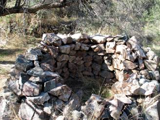
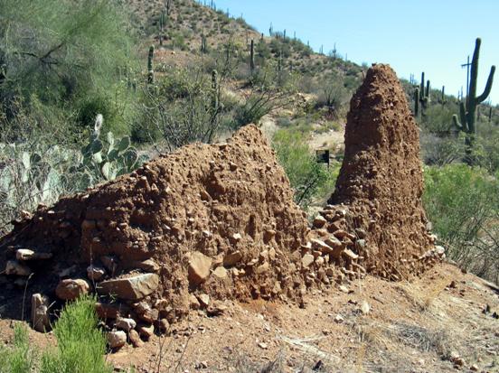
Kiln at Humbug – 2005 Photo
by:
Neal Du Shane
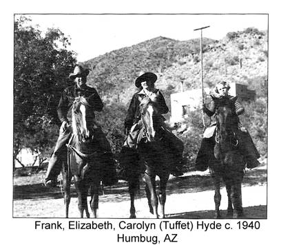
From Hyde’s point of view,
Humbug was not only a
gold (and later tungsten) endeavor. Humbug was Hyde’s definitive sanctuary.
Pictured above, he built a home at Humbug and eventually brought his wife,
Elizabeth, and daughter, Carolyn. Carolyn was known as “Tuffet,” and was brought for extended stays at the mine and
Tuffet became an
accomplished horsewoman. In the above picture Tuffet is seen holding a Polo
stick. An article in The Christian Science Monitor in April of
1944, when Tuffet was nearing her
fourteenth birthday, tells of Hyde and his daughter taking nighttime rides to
search for tungsten in scheelite with “mineral
lamps” that utilized ultraviolet rays. On one trip it began to rain heavily, Hyde and
Tuffet sought refuge in an old mine tunnel where a miner was making his home.
The miner bragged of the mine tunnel’s comforts, which included carbide lamp, radio and other living essentials of the era. The miner exclaimed he hadn’t seen one scorpion or rattlesnake
in the tunnel. Hyde turned on his blue light, scanned the tunnel, and four scorpions lit up the
dark. It’s uncertain the miner got another good night’s sleep in his formerly
secure abode, after Frank and Tuffet’s visit?
 During
World War II, Mining at Humbug ceased. Tuffet Hyde, in 1947, was a student at the University of Arizona,
brought fellow classmate Ruth Gaisford to Humbug for a
visit. This was the first of many trips Tuffet and Ruth took, to the
magnificence and serenity of the Southern Bradshaw’s. In 1956 Frank Hyde, by then divorced, visited Humbug his last time.
Frank Hyde died in Tucson in 1973 at the
age of 75. Tuffet left her
one-third interest in Humbug when she died in 1989, to her lifelong friend Ruth
Gaisford. For Ruth, as it was for Frank and Tuffet Hyde, the town
is not a mine, but a priceless retreat that must be conserved.
During
World War II, Mining at Humbug ceased. Tuffet Hyde, in 1947, was a student at the University of Arizona,
brought fellow classmate Ruth Gaisford to Humbug for a
visit. This was the first of many trips Tuffet and Ruth took, to the
magnificence and serenity of the Southern Bradshaw’s. In 1956 Frank Hyde, by then divorced, visited Humbug his last time.
Frank Hyde died in Tucson in 1973 at the
age of 75. Tuffet left her
one-third interest in Humbug when she died in 1989, to her lifelong friend Ruth
Gaisford. For Ruth, as it was for Frank and Tuffet Hyde, the town
is not a mine, but a priceless retreat that must be conserved.
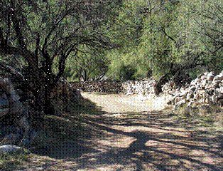
Humbug Entrance 2005, Photo: Neal Du
Shane
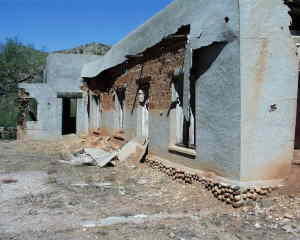
In 2006, Humbug has six
buildings remaining, the Hyde’s’ main house in desperate need of repair, a
three-apartment guesthouse and foreman’s residence, an assay office, the
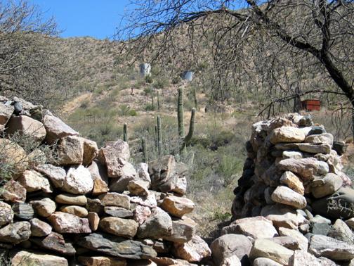
kitchen-dining building, and a stable with a corral. Humbug displays an
excellent example of dry stacking stone which is rarely found. Some uses are
functional, like the corral’ others are decorative, like the elaborate patio
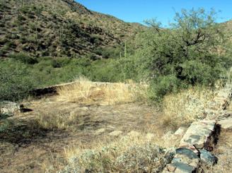
and garden walls in front of the Hyde home. The ruins of several other
residences dot both sides of the creek one of which is pioneer Charlie
Champies’ home, near the kiln.
Mill Foundation, Photo: Neal Du
Shane
 HUMBUG, AZ
Humbug, along with Columbia a distance of 2.24 miles down
stream, following the creek, came into existence during the early 1870's as
placer gold was found in Humbug Creek. A mill was constructed and the town operated until
the turn of the century. A caretaker resided at the mine for years and then
production started again. The town thrived and the mine was extensively worked
until the early 1930's. Warner Watkins, who had worked at Humbug in its later
years, told of what life was like when he had to drive to Wickenburg, a round
trip distance of 69 miles every night, to
get milk for the town, or how the miners would walk to Crown King (about 20 miles
uphill) every weekend to go to the saloon.
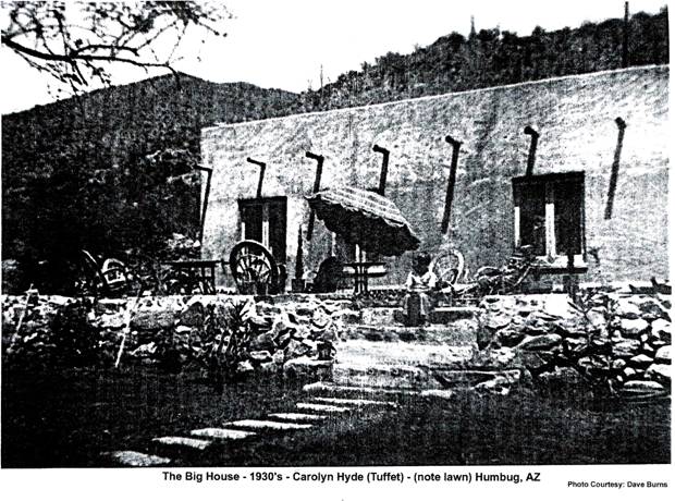
The Big House – c. 1930’s
Rod
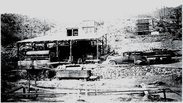
Mill – Frank Hyde’s – Humbug, AZ
Frank Hyde’s Rod Mill –
Humbug, AZ c. 1930’s Photo: Courtesy Dave
Burns
PLEASE DO NOT TRESSPASS. Humbug is on private property and all roads dead end
at Humbug, if you are past the locked gate without permission you are
trespassing. After gaining permission to proceed through the locked gate,
panoramic Humbug comes into
view, as you round a bend to your left on the four-wheel drive road and look
down in the Humbug Creek Valley. There are still buildings standing and are
spaced out along the northern canyon above Humbug Creek. Remnants of former pioneer homes, including Humbug
Pioneer miner Charlie Champie, the Humbug Kiln, line the southern banks of
Humbug Creek.
Philip
Varney in Arizona’s Best Ghost Towns” writes “When I visited the site in May of
1979, it had been very recently abandoned, for in one building were playing
cards on the kitchen table and assorted remnant of foodstuffs in the cupboard.
But the droppings on the floor indicated that coyotes and rodents were the only
current residents. The building left me with the eerie impression that the last
tenants grew weary of cards and so decided to pack up; it all seemed so
spur-of-the moment. I kept expecting someone to step out of a bedroom to ask
what I was doing in his home, but the evidence that Humbug had been abandoned
was indisputable.”
The
main home of Frank Hyde in 2006 is in desperate need of repair and will not
survive unless attention is given as soon as possible. The roof is leaking
allowing the double adobe walls to decay. The miners apartment building
however, is still be quite comfortable and in good repair. Dave Burns the
present caretaker resided in this structure. Humbug is too attractive and
desirable a place to remain uninhabited. Dave’s goal it to open Humbug up for
tourist visits. Although the 5 miles of four wheel drive road to reach Humbug
will limit visitations by the novas.
Sign posted at
main gate leading to Humbug, AZ
NOTICE
THIS IS NOT THE ROAD TO CROWN KING !! Go back south five miles until you cross Cow Creek.
Then proceed north.
THIS IS NOT THE ROAD TO NEW RIVER !! Go back south one mile and then proceed east. Follow the sign indicating BLM, access.
DO NOT TRESPASS ON PRIVATE PROPERTY.
THIS ROAD DOES NOT GO THROUGH. It goes to the top of the next ridge and dead ends.
THIS IS PRIVATE PROPERTY. SOMEONE LIVES HERE. If you are interested in the history of the Humbug Mining District, and would like to see and hear about Humbug, call 480-899-7317 and arrange a time to visit. We are happy to show the ghost town and tell about the history.
In Arizona, trespassing on a mining property is a FELONY.
This property has open mines and other hazards. Damaging gate or signs constitutes public endangerment, which is a FELONY.
Persons caught committing a felony can be ARRESTED AND DETAINED BY FORCE until a deputy can be summoned.
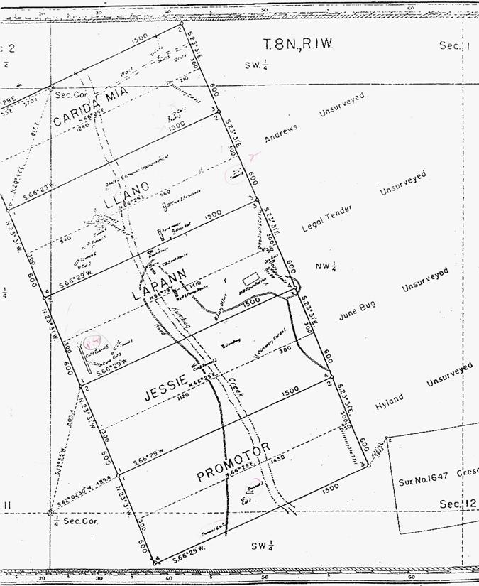
Town Layout
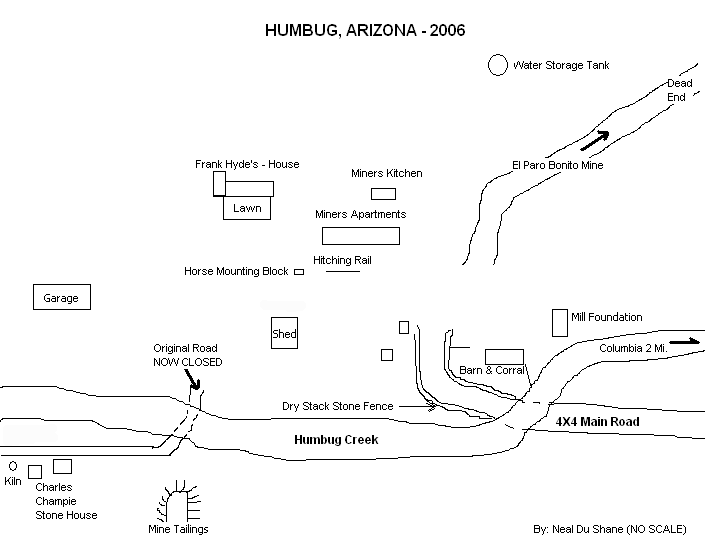
Humbug Topographical Map
|
Humbug Claims
SOJOURN THROUGH HISTORY
By: Neal Du Shane
In 2005, the secret to having one of the most
enjoyable trips to a Ghost Town in Arizona is calling ahead and getting
permission to meet Dave Burns at the Ghost Town property of Humbug. He is
extremely knowledgeable, cordial, packing and will take you on one of the most
historic tours of the property that I’ve ever experienced.
Photos by: Neal Du
Shane
Photograph by: Neal Du Shane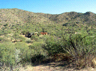
Humbug Cemetery
|
||||||
|
|
|
|
|
|
|
|
|
Yavapai
County, Arizona |
||||||
|
|
|
|
|
|
|
|
|
From north end of Lake Pleasant blacktop, L on
Castle Hot Springs Rd., R on Cow Creek Rd to
Columbia Rd, R to
"T" intersection, L to locked gate at Humbug |
||||||
|
|
|
|
|
|
|
|
|
|
|
|
|
|
|
|
|
|
Burials
= |
6 |
|
|
|
12/10/2005 |
|
Marker |
SURNAME |
FIRST
NAME |
MIDDLE
NAME |
BIRTH
DATE |
DEATH
DATE |
COMMENTS |
|
|
|
|
|
|
|
|
|
|
FOGARTY |
Pat |
|
|
|
Pile of Stone - No records
currently available |
|
|
LEE |
Johnny |
|
|
|
Pile of Stone - No records
currently available |
|
|
DOE |
Jane |
|
|
|
12 year old Hispanic girl - not buried
with the other 5. Short distance S.E. Grave is marked with a saguaro cactus
and stones covering grave |
|
|
DOE |
John |
|
|
|
Dowsing revealed burial - male |
|
|
DOE |
John |
|
|
|
Dowsing revealed burial - male |
|
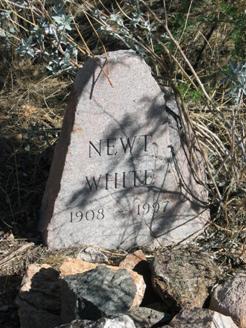
Y |
WHITE |
Newt |
Edward |
Feb. 23, 1908 |
Aug. 24, 1997 |
Born in Oregon, Son of Edward G.
& Adella E. White - Caretaker of Humbug - worked at the Champie Ranch for years |
|
|
|
|
|
|
|
|
|
|
6 |
|
|
|
|
|
|
|
|
|
|
|
|
|
|
NOTE: |
Humbug is on PRIVATE
PROPERTY - Do not
Trespass - Call 1-480-899-7317
and arrange for someone to meet you for your tour of Humbug. |
|||||
|
|
|
|
|
|
|
|
|
Contributors: Dave Burns, Neal Du Shane, Gene Simonds |
||||||
|
|
|
|
|
|
|
|
|
Submitted by: |
12/01/05 Neal Du Shane |
|
|
|
||
|
|
Revised: |
12/10/05 Neal Du Shane |
|
|
|
|
|
|
|
|
|
|
|
|
|
Material may be freely used by
non-commercial entities, as long as this |
||||||
|
message remains on all copied material, AND
permission is obtained from |
||||||
|
the contributor of the file. |
|
|
|
|||
|
|
|
|
|
|
|
|
|
These electronic pages may NOT be
reproduced in any format for profit |
||||||
|
or presentation by other organizations.
Persons or organizations |
||||||
|
desiring to use this material for
non-commercial purposes, MUST obtain |
||||||
|
the written consent of the contributor, OR
the legal representative of |
||||||
|
the submitter, and contact the listed
archivist with proof of this consent. |
||||||
|
|
|
|
|
|
|
|
|
This file
was contributed for free use. |
||||||
|
Contributor/Archives by: Neal Du Shane -
All rights reserved |
||||||
MILLS
By: Dave Burns
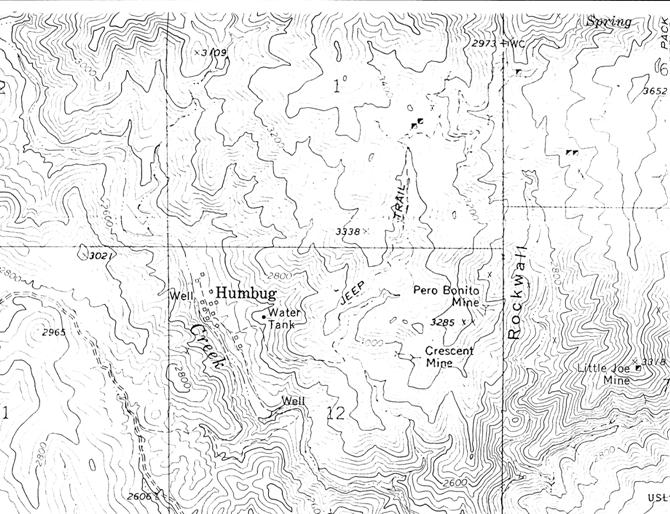
USGS map Columbia quadrangle
shows the canyons I have referenced.
It appears that "Humbug placers"
must refer to Swilling Gulch and Humbug
Creek near where
Swilling drains in. Swilling is the gulch coming from the east into
Humbug about half a mile or so north of Columbia. Rockwall and Carpenter come from the
north, parallel to Humbug, and drain into Swilling. This would put Humbug about
a mile north of the placers, and Columbia about a half mile south.
There is no sign of mill site or ruins at Sand Creek. It rarely has water anyway.
From 1882 thru 1934 there was sporadic mining in Humbug, Rockwall, Carpenter, and Swilling Gulches, and on Gold Hill. There were well over a hundred mines and
claims, a few of which I know a little bit about. The Beacon Light has a very
interesting history. The owner had a good mine in Swilling. He
owned the store, saloon, whorehouse, and boarding house. Not much money
left the area except in his pocket. After he was done mining, he moved to
Phoenix and started the Valley National Bank.
Other mines in the district: Sidewinder produced about
2,000 oz gold for Charlie Champie, Mountain Chief produced about
5,000 oz gold for CC, Little Annie about 1,000 oz
gold for Frank Hyde, Uncle Sam unknown amount
silver.
Lizzie Lee, Acquisition, Betty Lou, Top Notch, Gold Spring, Little Joseph, and Crescent were all
producers, but I don't have figures. There were many more that were only
prospects.
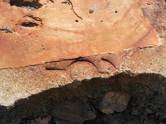
As with many mining camps of the era, a brand
or logo was adopted at Humbug. They chose a “Pick and Pan” as their insignia.
The picture at the left shows this insignia and is pressed into the concrete at
the ladies horse-mounting step, in the courtyard at Humbug.
|
NEWT
WHITE
Courtesy:
“Ranch Trails and Short Tales” by: Claire Champie Cordes
Edward Newton Whites grandfather was a scout on a
wagon train from Missouri across the Oregon Trail, finally landing in Lowell
Range, Oregon. They had many close calls
with the Indians; for many days they were afraid to build a fire. At night the
wagons would form a circle and the animals and people stayed in the center for
protection.
When they arrived in Lowell, Grandfather White married the girl he had admired all along the trail, Sally Hobbs, and Irish-German girl. From this union, eighteen children where born, the last was Newt’s father (Edward G. White). He turned out to be a restless, adventurous man who worked as little as possible. After he married Newt’s mother (Adella E. White), Newt and a sister (Annie May White, buried at Copperopolis, AZ Cemetery) were born.
The grandfather had built up a large estate; when he died, each child received a generous stake. Newt’s father soon spent his part, divorced his wife, and took his children to Tallahassee, Florida.
Newt was made to work from the time he was
six years old to help support his new mother and family. When Newt was about
fourteen his father decided to leave Florida so they took off on foot with
their bedrolls. They picked up and old cloth car top along the way and used it
for a tent to protect them from the rain. They caught rides on freight cars
part of the way; then while walking along the highway, a big bus stopped and
picked them up. He let them off the bus as he approached Tucson, but picked them up on the way out the next morning.
After letting them off in Phoenix, they had started across the desert on foot when a rancher
in a truck picked them up and took them to Rock Springs (AZ). From
there they walked on to Tip Top, then on to the Champie Ranch. At the dude ranch, Ann Douglas, the owner, needed a boy to do chores and help around
the ranch so she gave Newt a job. His father went on his way. Newt worked there
for years until the guest ranch sold. After that, he stayed in the area and
went to work for another Champie as a cowboy.
One day he was riding along out west of where
the other cowboys were camped when he jumped a cow and her calf as he rode
around the south side of Spring Mountain. There was a heavy growth of cholla cactus all over
that country. When he roped at the calf, his horse jumped over a cactus,
catching a ball cholla between his tail and leg, causing him to go wild. Off
Newt went with the coils of the rope wrapped around his arm and hands and the
other end tied secure to the saddle horn. The faster the horse ran, the more
cholla’s stuck to Newt on their way down the mountain. The horse finally fell
releasing the rope long enough for Newt to free himself. By this time he was
covered with cholla from head to toe, as well as many bruises and a broken leg.
He crawled to the top of a ridge to call for help. His boss finally heard the
call of distress and came to this rescue. They picked thorns out of Newt for
hours. Then they layed (1) him across a horse to get him to the ranch
headquarters. They then layed him on a cot in the back of a pickup and took him
to the hospital in Phoenix.
 He remained at St. Joseph’s for weeks.
Because he had a pinched artery in one leg (left), it had to be removed just
below the knee because of gangrene. After many weeks recovering, he became
interested in mining and worked with my mother and dad in their mining
projects.
He remained at St. Joseph’s for weeks.
Because he had a pinched artery in one leg (left), it had to be removed just
below the knee because of gangrene. After many weeks recovering, he became
interested in mining and worked with my mother and dad in their mining
projects.
Finally making contact with a mineral
surveying crew he was hired to work with the mining engineers and worked with
land and mineral surveying for many years until he retired at sixty-five. He
settled down on an old mining claim with two silent partners where he remains
today. At age seventy-eight, he is dreaming of selling his interest for at
least 10 million dollars. We hope it come true!
Photo by: Neal Du Shane
Note: Edward Newton White died August 24,
1997, his remains were cremated and the urn containing his ashes is buried at
the
Notably in attendance were: Dave Burns, Henry
Cordes and members of the Champie family.
Dave Burns relates that
Newt originally had a wooden leg after the amputation. Still working at the
Champie Guest Ranch, one of Newt’s jobs was to drive the wagon into town
(Morristown) and pick up and deliver the guests and supplies as needed. Newt
hollowed out the wooden leg, or it was hollow in the first place and Newt
carried the payroll and deposits in it for the ranch and guests. Newt was never
held up!
Cathy Cloin of Cordes, Arizona informed us that Newt worked in and about
Cordes for many years also and was a good friend of her grandfather Henry
Cordes. She showed us Newt’s room while he was staying at Cordes. One of Newt’s
old prosthesis is now at the Cordes Store in downtown
Cordes. We checked . . . there was no money inside it.
From information provided by Cathy, she has
numerous mining claims that Newt was either a partner in or owned outright. In
one of the letters it made reference that Newt White was the Mayor of Cordes.
Photorgraph Courtesy: Cathy Cordes
Picture of: Guy Scott, Henry Cordes, Newt White
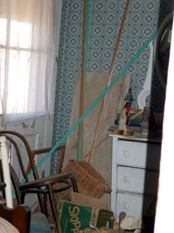
Photo Courtesy: Neal Du Shane
Newt Whites
room at Cordes, AZ
Don Harp Memories of Newt
04/07/08
I now live in
He loved to see us come for a visit, we
brought him soft drinks and food and most importantly, company. He was always
smiling and when he saw our white Nissan and he was right there to wave
and welcome us. He nudged me in the sides every time and asked if I was taking
care of my beautiful lady, my ex was a beautiful blonde and he loved to see her
show up more than me I think!! We went up one day and the road was blocked off
and we wondered what was going on, it was Christmas and we had a gift for Newt.
For years we had gone and was always welcome so we went on in to see
Newt, give him the gift and visit for a while. We left the gift
but did not leave the food as it was hot and it would spoil. His
favorite was cold watermelon, cantaloupe and strawberries. We miss seeing Newt
and loved to just walk around Humbug. I have an old hand saw Newt gave me,
said he had used over twenty years ago, now it would be 30 years ago. It
was very old and the handle was weathered and cracked badly, repaired by Newt
with bailing wire wrapped around it to hold it together. I still have that saw,
I wrote his name on it. I was thinking about trying to contact Cathy
Cordes of Cordes and ask her if she wanted it to place on display with his
leg.
Of all the stories we heard, he never
told us about being drug through the Cholla Cactus!! That was funny to
read but must have been awful for Newt. Maybe it was too painful to talk
about!!!
Take care and thanks for posting this, I
stumbled onto it quite by accident and glad I did. I heard Newt was taken to a
care home but no idea where or we would have gone to see him. Now we know
thanks to you.
Wooden directional sign to Humbug Gold Mine’s
Humbug 2006
By: Neal Du Shane
Humbug continues to maintain its status in Arizona’s rich mining history. Much of its historic past is still being maintained. Other aspects of Humbugs history is being returned to the earth. As mentioned earlier the goal of Dave Burns is to maintain this Ghost Town, providing private public tours by appointment only. Once a year, Dave holds an Open House, making Humbug open to the public.
 One noticeable decline is “The Big
House”, once standing as the landmark in its proud heritage at Humbug. Its
adobe walls are now showing signs of decay and disrepair. The roof is leaking
with each rain, allowing water to penetrate the once proud walls. Before this
structure reaches beyond repair it would be worth the effort if volunteers
could reconstruct this structure to a state allowing no further decay.
Preserving its once proud heritage as the shining light of Humbug. If you are
interested in volunteering your skills and labor, contact Dave Burns the
current caretaker of Humbug.
One noticeable decline is “The Big
House”, once standing as the landmark in its proud heritage at Humbug. Its
adobe walls are now showing signs of decay and disrepair. The roof is leaking
with each rain, allowing water to penetrate the once proud walls. Before this
structure reaches beyond repair it would be worth the effort if volunteers
could reconstruct this structure to a state allowing no further decay.
Preserving its once proud heritage as the shining light of Humbug. If you are
interested in volunteering your skills and labor, contact Dave Burns the
current caretaker of Humbug.
The statuesque front yard was the pride of Humbug and the Hyde’s now stands unattended and forlorn, being returned to its natural state. One can only stand in awe on the Big House front porch and listen where silence has lease. Imagining the hustle, bustle and mining clatter that filled this thriving community in days of yore.
Photo’s above courtesy: Neal Du Shane
Humbug “Open House”
By: Neal Du Shane
March 4 – 5, 2006 marked the first Humbug Potluck and Open House. Dave Burns was instrumental in organizing this get together with the goal of a fun filled weekend. His efforts were right on the mark. At one time the count was approximately 50 people attending. It is speculated that it has been a few decades since this many people walked the streets of Humbug at one time.
Many that attended Saturday stayed over Saturday night and were delighted with a tour to the El Paro Bonito Mine with its 500’ adit on Sunday morning. Dave reports much of the equipment is just as it was left the day they stopped mining this mine.
The Open House was a great opportunity for newcomers and old timers to rub elbows and share interesting facts regarding this area.
Dave gave tours of Humbug and shared his knowledge of this Historic Arizona Ghost Town. Great food, good times and fun facts were the highlight of this exceptional event. Many thanks to Dave and Theresa for their kindness and hospitality they extended to everyone attending.
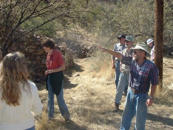
Dave Burns giving tour to guests at “Humbug Open House” – March 4, 2006 (Photo: Reba Grandrud)
Humbug, AZ 2006, Photo: Neal Du Shane
Adobe Wall – Humbug,
AZ 2006, Photo: Neal
Du Shane
(1) To keep with authentic historical spelling and punctuation as written by the original author.
Acknowledgement:
A special thank you, to all that contributed making this possible:
Dave Burns, Darrell & Barbara Steffen, Philip Varnie, Arizona Bureau of Mines and Mineral Resources, Gary Grant, Clair Champie Cordes, Larry & Betty Gill, Gene Simonds, Cathy Cloin, Joyce Du Shane, Pioneer’s Cemetery Association (PCA) of Arizona, Betty and Rusty Hastings, Ira Kelley.
Transcribed, Compiled and Edited by: Neal Du Shane
Copyright ©2003-2013 Neal Du Shane
All rights reserved. Information contained within this website may be
used
for personal family history purposes, but not for financial profit of any
kind.
All contents of this website are willed to the American Pioneer &
Cemetery Research Project (APCRP).
HOME | BOOSTER | CEMETERIES | EDUCATION
| GHOST TOWNS
| HEADSTONE
MINOTTO
|PICTURES
| ROADS
| JACK SWILLING
| TEN DAY TRAMPS