HOME | BOOSTER | CEMETERIES | EDUCATION
| GHOST TOWNS
| HEADSTONE
MINOTTO
| PICTURES
| ROADS
| JACK SWILLING
| TEN DAY TRAMPS
American Pioneer & Cemetery Research Project
Internet
Presentation
Version 012209

By:
Kathy Block
This was a US Army fort from 1862 to 1894. The site became a
National Historic Site in 1964, dedicated in 1972. It contains 970 acres
dedicated to preserving the Butterfield Overland Mail Route, the Apache Pass
Stage Station, Apache Spring, and the Fort Bowie complex.
Visitors, except those with special permission to drive in
on a road to the Visitor Center, must walk a gentle trail to the Visitor Center
and ruins. Trail is 1.5 miles each way from parking lot.
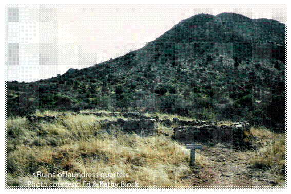
It is believed that the laundress had to haul water from a spring
1/4 mile away and live there in this structure.
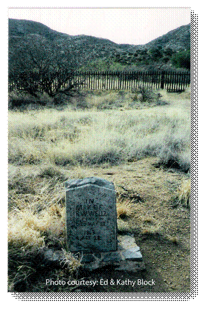
The cemetery is located about half way to the Visitor Center
from the parking lot. (See map). When we visited the site in Dec.2000,
the cemetery was unmaintained, with tall grass and weeds, little paths beaten
thru the area, a forlorn headstone (see photo), and many unmarked mounds
of stones.
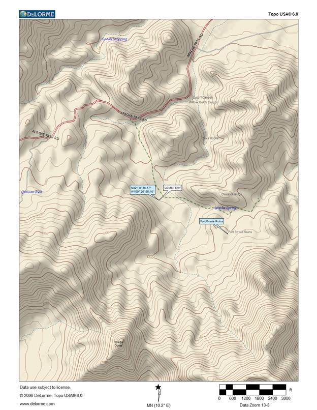
The next year the Park Service commissioned studies and
restoration with a team that used a Geometrics G-856AX magnetometer, and
historic photographs, to locate, survey, and restore remaining graves in
the cemetery.
From the article, it appears that possibly 102 graves were located in this cemetery, including soldiers, Native Americans, children.
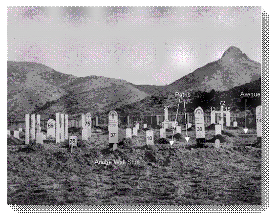
Some
observations on the Fort Bowie cemetery as it was in 1886 by Charles
Fletcher Lummis (1859-1928).
Lummis was an adventuresome, freethinking
writer and reporter for the Los Angeles Times. He covered
3,507 miles in 143 days reporting on various places, peoples, and events on
the Southwestern frontier. One
of his dispatches concerned Fort Bowie, Arizona Territory, April 15, 1886.
Entitled, "Headboards", he described the cemetery there. A few
interesting observations:" Graveyards, as a rule, haven't much of a pull on
me. Indeed they strike me as unsociable and slow."
He continues on to describe the burial ground below the Fort, which
was still actively being used!
He liked a high picket fence with white headboards shining in the sun. He
told of various flowers on the ground and a buckhorn cactus spreading its
"prickly antlers" on some unforgotten grave here and there.
Most of the graves were marked with pine boards planed and painted
white, with cramped block letters in straggling lines.
At the time of his visit there were 33 graves, with 7 being children. On
that he wrote: "The presumption is that they passed away in the course of
nature." He quotes a number of inscriptions on the graves. Here are a few
examples: "O.O. SPENCE, Born in Pennsylvania, Aged 28 years. Killed by
Indians April 7,1876." and nearby, "NICHOLAS M. ROGERS, Born in St. Joseph,
Mo. Killed by Indians April 7, 1876."
Apparently both men were killed by an unruly Chiricahua named Pionsenay,
which ultimately led to the attempted removal of the Chircahuas to San Carlo
Reserve, and proved to be a disaster for Indian-white affairs in Arizona.
A few other headstones were: "JOHN McWILLIAMS, Killed by Apaches, Feb.26,
1872, Aged 26. " and "A.F.BRICE, F.PETTY, F.DONOVAN, Killed by Indians in
Apache Pass, Jan.24, 1872." These men were coming up, two on horseback and
one on a buckboard close to this very spot, when lurking Apaches shot them
down." A similar grave says, "In Memoriam of GEO. KNOWLES, Prvt.Co.H. U.S.
Inf./captured and tortured to death by Apache Indians, May 26, 1868". He and
the second guard surrendered while acting as guards for a stage down the
pass that was "jumped" by Apaches who killed the driver. Knowles was
captured without firing a shot and later killed.
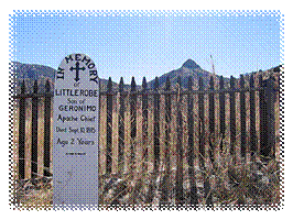
Finally, he quotes the inscription on Little Robe's memorial (pictured) and
one for "In Memory of Marcia, An Apache child, Died July 3, 1885, Age 3
years." Lummis says about these:
"These little savages, captured with others of the renegades last summer,
died here in the guard-house. It was a soldierly and manly heart which took
care that these poor little waifs were decently buried, and that their last
resting place was marked. It was an act of humaneness of which I fear but
few Arizona civilians would be
capable."
Most of these wooden markers have long disappeared now, but records like
these by Lummis help preserve the stories of these long- ago men killed in
the very real wars with Apaches at Fort Bowie.
Over time many remains have been moved to other places. But
were the actual remains moved or only the headstones?
It would be interesting to look at records in the Visitor
Center (nicely staffed at times with knowledgeable volunteer historians) to
answer why the people died - injuries from combat with the Apaches?
disease? accidents? Somewhere history will speak to the visitor!!!
American Pioneer & Cemetery Research Project
Internet
Presentation
Version 012209
WebMaster: Neal Du Shane
Copyright
©2003-2008 Neal Du Shane
All rights reserved. Information contained within this website may be
used
for personal family history purposes, but not for financial profit.
All contents of this website are willed to the American Pioneer & Cemetery
Research Project (APCRP).
HOME | BOOSTER | CEMETERIES | EDUCATION
| GHOST TOWNS
| HEADSTONE
MINOTTO
| PICTURES
| ROADS
| JACK SWILLING
| TEN DAY TRAMPS