HOME | BOOSTER | CEMETERIES | EDUCATION | GHOST TOWNS | HEADSTONE
MINOTTO | PICTURES | ROADS | JACK SWILLING | TEN DAY TRAMPS
American Pioneer & Cemetery Research Project
Internet Presentation
Version 070709
Scenic Loop Placer Graves Site
By Allan Hall –
APCRP
Certified Coordinator
The area north
of Wickenburg, between the Hassayampa River and the old mining communities of
Stanton, Octave and Weaver to the north, has been the target of gold seekers
since 1863. After potato-sized nuggets
were reportedly discovered on top of Rich Hill, hard rock and placer miners
poured into the district. You didn’t
have to be a plumber to understand that things run downhill, and this concept
was not lost on the prospectors – for good reason. A significant portion of this area is
alluvial – formed by the inexorable erosion and flooding that wears down
mountains and moves soil to lower areas.
See Figure 1.
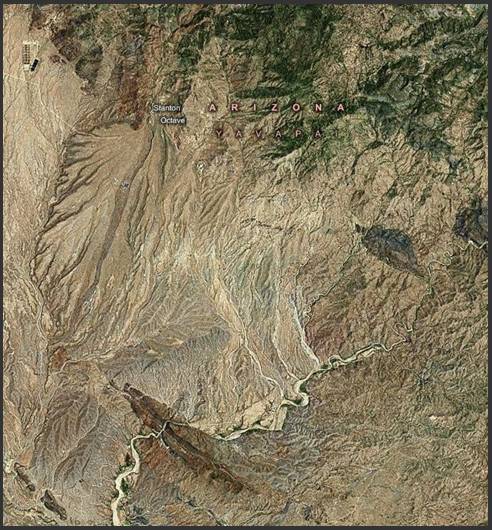
Figure 1, Alluvial area between
These same forces have been transporting
and depositing gold in the washes and alluvial fans for millions of years. Unfortunately,
the lack of reliable sources of water required early placer miners to use
inefficient methods, such as dry rockers.
The amount of gold taken by successive waves of small claim holders will
never be known, but one thing is certain – the people who sought their fortune (or
to merely eke out an existence) left a legacy of isolated graves throughout the
area.
A
Closer Look
This article focuses on a single wash where
we have confirmed at least thirty graves in nine separate burial sites, as shown
in Figure 2.
Three visits have been made to the area since March, 2008, but no
systematic survey has been conducted yet.
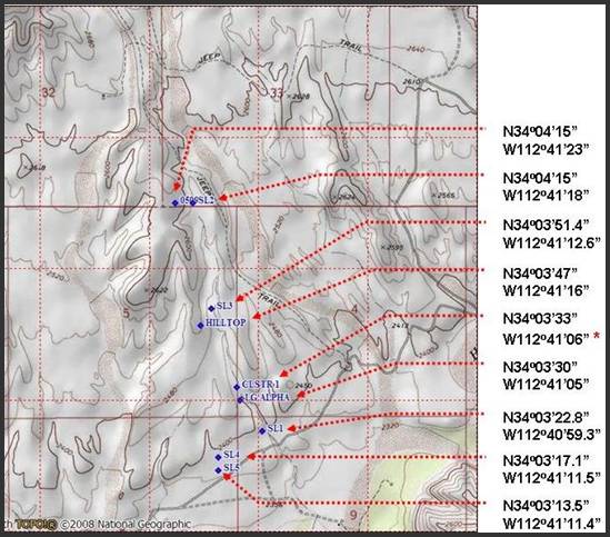
Figure 2, Current
inventory of grave sites. GPS Datum is
WGS84.
The distance separating the lower grave,
near the bottom of Figure 2, and the
northernmost pair of graves is 6212 feet.
Most burials are located along the margins of the wash or on the
adjacent hillsides. The distance from
the Hassayampa River to Stanton is slightly greater than seven miles, and the
terrain features washes and gullies that run in a generally north to south
direction. Given the fact that less than
1.2 miles of a single small wash have been examined - and that only
superficially – the potential for discovering more pioneer graves is
considerable. Other APCRP members have
reported lone graves a few miles to the northwest near Martinez, Weaver and
Antelope Creeks.
A brief characterization of the nine
sites includes the following:
o One
cemetery containing 16 male graves (Hilltop).
o One
cluster containing six male and one female graves
(CLSTR 1).
o Seven
dispersed lone graves – all male.
o Except
for the “Hilltop” location, all graves contain rock outlines or mounds.
o The
nine sites may span the period between the 1860’s and 1930’s.
Credit for discovery of the first grave
sites goes to local members of the Miners Creek Prospecting Club, who are working
placer claims on several sections of BLM land.
Their invitation and continuing observations have enabled
APCRP to
establish what we now call the “Scenic Loop Placer Graves” area.
The
Lower Graves
The three lower graves sites (SL5, SL4
and SL1) reside on an alluvial fan between the hills and river. This area has a very gentle slope and has
seen the deposition of much soil during the current geologic era. Sedimentation has become so pronounced that
no rocky prominences are visible and there are almost no rocks or boulder
laying on the surface. This feature has
made it easy to locate the three graves described below.
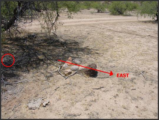
Figure 3, Male Grave
Designated “SL5”
Figure 3
shows the southernmost grave in the Scenic Loop Placer Graves group, as listed
in Figure 2.
The dark lava boulder accurately marks the head position of this
juvenile grave, but the dimension extends beyond the small cluster of rocks to
the left of the headstone. It is likely
that some disturbance (flooding, cattle or otherwise) has caused some
dislocation of the rock mound. Notice that
there is a gray boulder at the extreme left center of the photo, in the shade
of the mesquite tree. That rock may
belong to the original grave mound.
Based upon measurements, I estimate this juvenile to be four years or
less in age. This site has not been
restored.
The apparent “flatness” of the terrain in
this photo characterizes the area between the hills (north and right) and the
river (south and left). You can readily
see that it has a flat appearance and contains no rocky outcroppings.
The trail in the upper portion of the
photo leads north toward the “Hilltop” cemetery, which will be discussed
later. This trail dates to at least
1890, but may be as old as 1865.
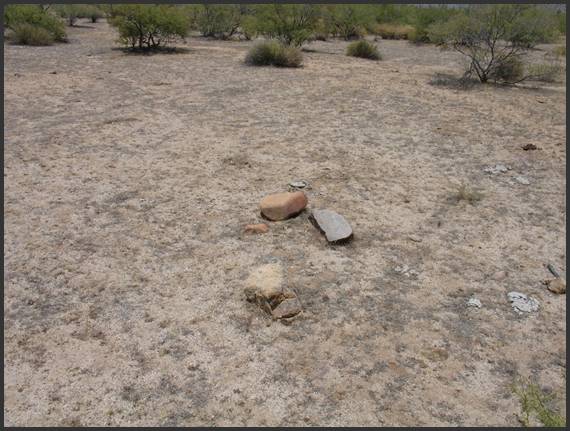
Figure 4, Male Grave
Designated “SL4”
Figure 4
is the second grave from the south/bottom and is identified as “SL4” in this
article. The distance between SL5 and
SL4 is only 364 feet, but this photo shows a pronounced change in the slope, or
gradient, because it is closer to the hills that are left and north. SL4 is also a juvenile male grave, but the
dimensions suggest an age that is perhaps eight to twelve years. The large reddish stone shows the head-end of
the grave and the orientation is nearly identical to SL5. In other words, both graves face toward the
west. Notice again the absence of rocky
outcroppings in this photo.
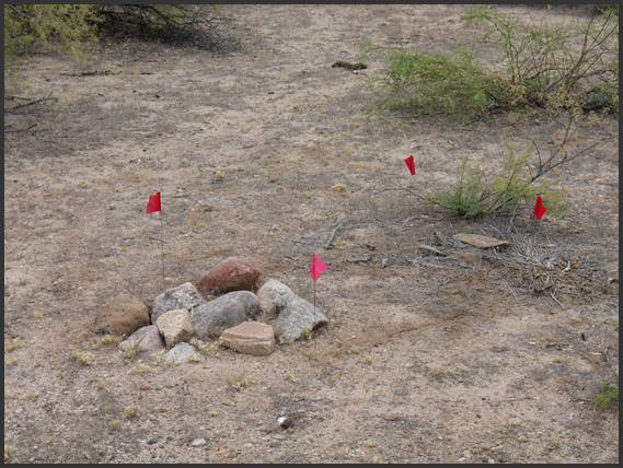
Figure 5, Male Grave
Designated “SL1”
Figure 5
shows the third grave from the south/bottom and is identified as “SL1.” (The naming convention has no bearing on the
order in which graves were discovered.)
This photo was taken after the dimensions of the juvenile grave were
established. The small wash that is the
subject of this article is to the left/north of the photo. As with Figure 3
& 4, the area around this grave shows an absence of surface rocks.
The SL1 grave is also a male juvenile
and, based upon dimensions, is thought to be between six to ten years of
age. Grave orientation indicates that it
faces toward the southeast. Flagging
pins show the grave outline. It is
likely that the rock mound at the left end was intended to be a head marker.
There is considerable similarity between
the three lower graves:
o They
are all juvenile males
o Each
is marked with rocks
o Each
grave is situated in an area that is relatively smooth and is (otherwise) free
of stray rocks or natural outcroppings.
Moving
Up the Wash
The first three graves are located at the
lower end of the survey area. As you
proceed north, the terrain turns into a typical wash with low hillsides on the
east and west. Rocky material - primarily
boulders and gravel - becomes much more pronounced.
Figure 6, First
Grave Located in
The lone adult male grave in Figure 6 is located next to the wash (partially
visible in the upper right corner of the photo). This is the fourth grave site above the
bottom, as shown in the topo map in Figure 2. It is designated as “LG-Alpha” to signify
that it was the first grave to be confirmed in this area.
The rock outline in the photo is
virtually unchanged from when it was first discovered by a member of the Miners
Creek Prospecting Club in early 2008.
After being alerted to the grave site, I verified the dimensions, set
corner pins, and then straightened the rock outline. The original stone at the upper end of the
grave was replaced by me with a larger rock to improve the visual reference to
the head position.
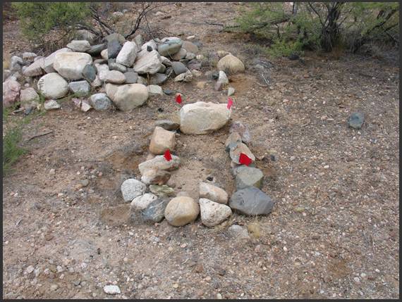
Figure 7, Cluster 1-A
Approximately 100 yards north of the “LG
Alpha” grave there is an unusual cluster, partially shown in Figure 7. The
grave in photo center is that of a young juvenile male that measures 34” tall
by 14” in width. The headstone (which is
untouched) appears to have been partially shaped prior to placement. The rock outline was straightened by me after
dimensions were established during the most recent survey in July, 2009. Notice that some of the relocated stones
exposed the build up of sediment
The rock-mounded area above and left of
the juvenile grave contains three burials – one female and two males. Because these graves have a common rock mound,
there is reason to believe they are co-burials (that is – the three burials may
have occurred at the same time. The
directional orientation of these four graves faces toward the east.
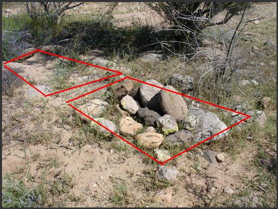
Figure 8, Cluster
1-B
There are three more male graves approximately
50 feet north of Cluster 1-A, shown in Figure 7.
Two of these graves are shown in Figure 8, and the third is out of view to the
left. The grave in the center foreground
is obviously rock-mounded, while the grave at upper left is faintly outlined and
covered by sand. Preliminary surveys
indicate that both are adult males that face in a northerly direction.
Whether cluster 1-A and 1-B are connected
by a common event, a historical era, or a shared ethnicity is unknown at this
time. The physical separation of 1-A and
1-B suggests these graves are not related in a familial sense, but that does
not mean they are not connected in some other way. Until or unless historical documentation can
prove otherwise, I am forced to describe these seven graves as a common (but
dispersed) cluster.
The
Hilltop Cemetery
The sixth burial ground, identified as
the “Hilltop Cemetery,” is unusual in several respects.
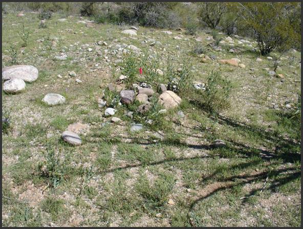
Figure 9,
Figure 9
provides a view of the central area of the burial ground, with a marker flag
showing one of the sixteen male graves.
The wash is downhill beyond the upper right corner of the photo. If this does not have the appearance of a
traditional cemetery, you are not alone in that judgment.
The graves are dispersed over an area of
roughly 20,000 square feet and do not appear to be well organized – that is,
there are no discernable rows.
Directional orientation of the graves appears (at this time) to be
random. Unlike the grave sites shown in Figures 3-8, there is no consistency in the use of
rock outlines or mounds. If anything, it
appears as if there was a conscious effort to obscure the site.
It would be tempting to classify this as
a large grave cluster, except for one thing…
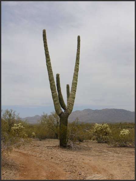
Figure 10, Saguaro
Landmark at
Figure 10
shows a stately saguaro that is adjacent to the cemetery. It was purposely “topped” many decades ago,
causing it to produce the “V” shape when new arms grew in place. Some APCRP
members are familiar with this phenomenon and have found it to be a reliable
landmark to graves and old trails. I
believe it is no coincidence that this saguaro is only a few yards from the
cemetery.
The “Hilltop” needs to be methodically
surveyed and documented when cool weather returns. Neal Du Shane and I have managed only a
preliminary assessment, having confirmed the presence of sixteen graves in a
highly disorganized site. This is an
unusual place that deserves more study.
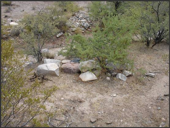
Figure 11, Male
Grave in
Approximately 445 feet northwest of the
Hilltop Cemetery is the seventh grave site, shown in Figure
11. It is an adult male with a
fully covered mound of rocks and boulders and is situated on the west margin of
the wash. The acacia and mesquite need
to be cleared before a proper survey can be completed. The long axis of the grave appears to be
nearly six feet in length and directional orientation is roughly NNE to
SSW. The head-end of the grave has not
yet been determined. The area on the
opposite side of the wash, near the top of the photo, also needs to be
thoroughly investigated.
Graves
at Northern Edge of Search Area
The final two grave sites at the upper
end of the search area are virtually parallel with each other at N 34o 04’ 15”
latitude. They are, however, on opposite
sides of the wash. The grave on the
western side is a juvenile, as shown in Figure 12.
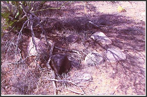
Figure 12, Juvenile
Grave Designated “SL9”. Courtesy of
Miners Creek
Unfortunately, I ended up on a trail on
the wrong side of the wash and was unable to reach this site to do a
survey. The photo, which was kindly
provided by the Miners Creek Prospecting Club, indicates a very neat rock
outline that appears to be completely undisturbed. I can only estimate its size to be barely two
feet in length, so this was probably an infant or very young child. The second grave is above the wash on the
east side and is an adult male with a partial rock outline. These two graves probably share no relationship,
since they are separate by a distance of 420 feet. These sites need to be revisited to complete
proper surveys and documentation.
Questions…
You can’t help but wonder about the
circumstances that produced the burial sites shown in this article. Why are there so many lone graves of
children? What year was the saguaro
topped to produce the landmark adjacent to the Hilltop Cemetery, and why is
that site so disorganized? With nine
burial sites (and counting) along a 1.2 mile stretch of this wash, how many
more graves remain to be found? Since
this is a small and obscure wash, what waits to be discovered in the larger
washes that run from the Stanton - Octave area down to the Hassayampa? Obviously, much more exploration is needed.
The article opened with a reference to
mining activity that began in the mid 1860’s.
Mining camps and settlements were established at Weaver, Stanton,
Octave, Yarnell and Congress. To the south, Vulture City was a much larger
mining town than Wickenburg; but a reliable history of the area in between is
pretty thin. Trails existed before roads
like “Stanton-Hall” and the Congress road were built, and these routes were
used by miners, settlers and travelers.
There were ongoing hostilities between the Anglo settlers and the
Yavapai and Apache tribes until about 1873, and robberies and killings by
outlaws occurred frequently. More than a
few people probably met their death through violent disagreements over mining
claims.
Although events such as these are likely
contributors to some of the burials, it does not explain the lone graves of
children very well. Anecdotal
information exists of “Depression Camps” that existed north and east of
Wickenburg for a time during the 1930’s.
It is possible that some graves, (such as SL5, SL4 and SL1) may be
attributed to the personal tragedies of families who moved through this area in
a time of national misfortune.
Directions
Access to the wash and grave sites begins
north of Wickenburg at milepost 195 on US-93 where Scenic Loop Drive
begins. The road becomes dirt after
about 200 yards. Remain on the main
roadway until you come to the following coordinates:
N 34o 03’ 19” by W 112o
40’ 59” (WGS84)
This is the point where you will turn
left (north) into the wash. I recommend
that you preload these coordinates in your GPS unit so that you will obtain
directional and distance guidance as you approach the trail. There are a myriad of recreational trails in
this area and visual navigation and ‘dead reckoning’ will be difficult.
If you would like a detailed map with
complete GPS Tracks, just let Neal or me know.
I will put together a complete route with mileage checks for you in the
next few weeks.
Obviously, much more exploration is
needed.
All Photographs by Author.
American Pioneer & Cemetery Research Project
Internet Presentation
Version 070709
WebMaster:
Neal Du Shane
Copyright © 2003 - 2009
Neal Du Shane
All rights reserved. Information contained within this website may be used
for personal family history purposes, but not for financial profit or gain.
All contents of this website are willed to the American Pioneer & Cemetery Research Project (APCRP).
HOME | BOOSTER | CEMETERIES | EDUCATION | GHOST TOWNS | HEADSTONE
MINOTTO | PICTURES | ROADS | JACK SWILLING | TEN DAY TRAMPS