HOME | BOOSTER | CEMETERIES | EDUCATION | GHOST TOWNS | HEADSTONE
MINOTTO | PICTURES | ROADS | JACK SWILLING | TEN DAY TRAMPS
American Pioneer & Cemetery Research Project
Internet Presentation
Version 041609
Dry Stack Walls
A Pioneer
Legacy
By Allan Hall
The second article on Dry Stack Walls provided photos and interpretive
text on the identification and construction of pack trails. Part Three describes walls that can be
found at mines and settlements, including heavy walls for mining operations,
retaining walls, corrals and foundations.
Part Three: Heavy Walls and Foundations
We have all visited (or seen at a distance) numerous mines that had no dry stack walls, even those of a humble or crude nature. Although the presence of walls is certainly not a confirmation that a mine achieved financial success, it does at least indicate that there was sufficient expectation to warrant financial investment.
Let’s return briefly to the lead photo that originally appeared in Part One, repeated below for convenience. Figure 1 demonstrates two types of walls at the Gold Bar Mine.
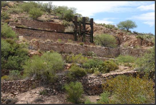
Figure 1, Gold Bar Mine Stamp Mill and Road
The massive, four-tiered wall contained a five stamp mill and the equipment required to operate the stamps. These walls are nearly two feet thick and are mortared, and do not qualify as dry stacks. The vibration induced by constant pounding of the stamp mill required a more durable construction than was possible with dry stack walls. The heavy wood structure is a portion of the original frame that supported the stamps.1 However, the lower wall in the foreground is a dry stack construction and supports a road connecting one of the mine shafts to the stamp mill and ore separation sites. As you can see, a rather substantial vertical rise (from base to top) was required to permit a roadway that was wide enough to support wagons and, eventually, trucks. The lower retaining wall appears to be made entirely of native rock, but it is tightly constructed and remains in very good condition.
The stones used in the mortared walls are distinctly lighter in color and probably were transported to the site, where they were shaped by stone masons.
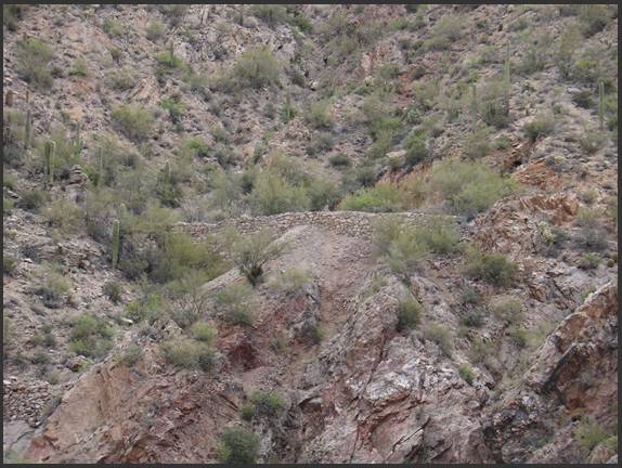
Figure 2, Dry Stack
at
Figure 2 show two dry stack walls at the White Mine, which is
located above the
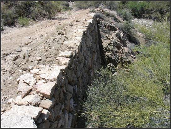
Figure 3, Close-up Detail of Mine Dry Stack
To borrow a phrase: “I never met a dry stack wall that I didn’t like!” This is true whether it is rough and crude or precise, as shown in Figure 3. This wall was built to support heavy loads at a mine and remains in exceptional condition due to the quality of construction. Notice also that the roadway, which still accommodates vehicular traffic, has not eroded over the decades. This wall testifies to thoughtful construction, craftsmanship and precision. The outer face of stones is natural, yet the smooth texture and straight lines show that each rock was carefully placed to provide strength and a uniform surface. It is questionable whether architectural beauty was a design factor (which I doubt). The important point is that the laborers who constructed it were careful craftsmen.
The columns shown in Figure 4 below are a mystery to me. I surmise that they would have supported heavy beams and planks, but I am not certain.
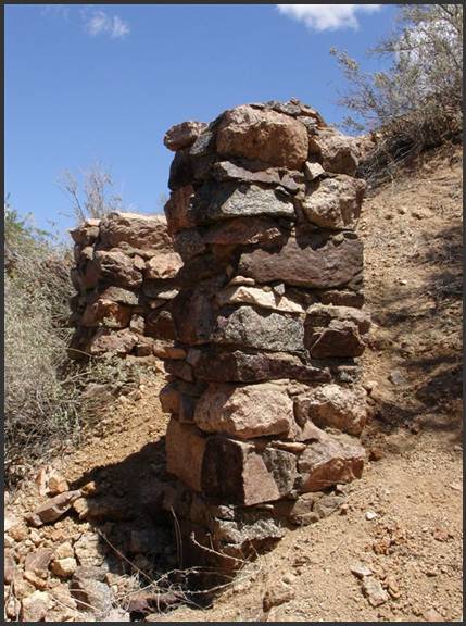
Figure 4, Dry Stack Columns
The tops of both columns are equal in height and a small amount of mortar was used to hold the stone edges in place. These structures could have supported significant weight, but I question whether they would have been able to withstand vibration or significant lateral movement. As you can see, the hillside rises steeply above these columns, so it seems unlikely they were built to support a wood deck.
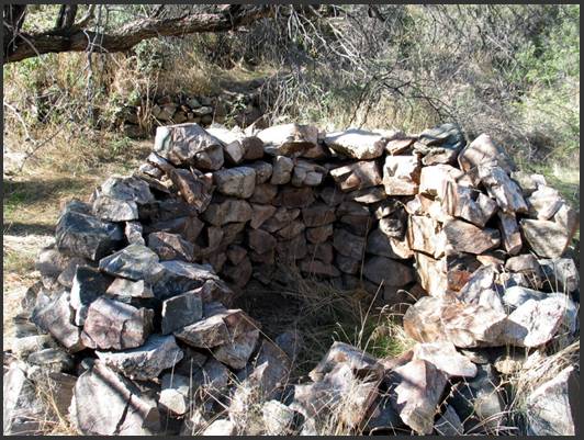
Figure 5, Humbug Kiln. Photo by Neal Du Shane
Figure 5 shows a dry stack wall that is entirely different in shape and purpose. This round structure served as a kiln at the original settlement location of Charlie Champie in the lower Bradshaw Mountains. His dry stack cabin is about thirty feet south of the kiln and his mine is another 200 feet beyond. Although it is common to think of kilns as fully enclosed structures and typically made of bricks, this rough structure would have generated enough heat to melt silver and gold. The Champie kiln measures approximately four feet in height by six feet in width and probably dates to the 1860’s.
As I mentioned in Part One of this series, the variety of dry stack walls seems almost limitless. Figure 6 shows stacked walls that border the trail leading into the ghost town of Humbug. Aside from the beauty of this photo, I am compelled to imagine the back-breaking effort that went into its construction; it reminds me of walls built by farmers in New England during the colonial period, as they cleared their fields for crops.
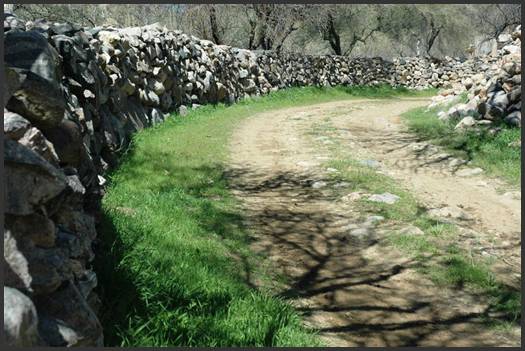
Figure 6, Entrance to Humbug. Photo by Neal Du Shane
If you are familiar with Humbug Creek, you will know there is no shortage of smooth “river rocks” that would serve as material for this wall. Dave Burns, the caretaker at Humbug, very kindly provided the following background on these walls:
“Regarding the walls at Humbug, they are all local stone. Much of the construction involved the use of Mexican laborers who were locally recruited. I do not know about some of the work done in the 1880's, probably much of it was done by Charles Champie and Johnny Lee, but when the mill site was built, they may have hired laborers. The entryway was done at two separate times. The east [left] side of the road consists of corral walls, where burros were kept. The west side was done in 1934, when mining was discontinued, and improvements were made to convert Humbug into a dude ranch resort. Decorative stonework, indoor plumbing, hitching rail, stone mounting block, electricity, etc., were added then. The resort was not a big success, as the dude ranch fad had passed.”
Dry stacks also provided secure enclosures for work animals and livestock during the pioneer era. Figure 7 provides an example of a small corral for burros. It is interesting to note the general absence of fence posts which, in the 1870-80’s era would have been costly. Although the elevation and annual rainfall at Humbug (~2500 feet) supports the growth of ocotillo, there is no evidence they were used to create the type of “live fences” that are found in other locations in the high desert. Native rock was so abundant that the settlers at Humbug may have seen no need to use other materials.
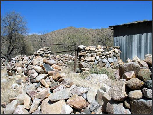
Figure 7, Burro Corral at Humbug. Photo by Neal Du Shane
Containment walls for work animals and livestock were not
limited to small corrals. Figure 8
shows a large walled area in the
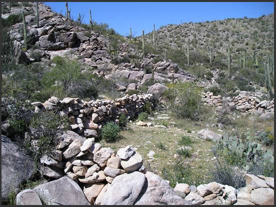
Figure 8, Fence Wall
in
The size of this walled enclosure is about 75 feet on each side and measures about four feet in height. I subscribe to the concept that “form follows function”. In this case, the size of the containment area must have served for a large number of animals (possibly goats). The “Dushey Well” was located nearby (uphill) and probably provided the water. Today, this area is range land for cattle and water is still supplied to a small cattle tank right of this photo.
Several things intrigue me about this wall. For example, although it has a haphazard appearance it must have effectively served its purpose and it has endured from (probably) the late 1800’s until today. Other photos reveal that it is generally two feet wide at the base and does not taper to a narrower width at the top. Finally, look at the size of the boulders in this wall. Some of them must weigh 300 pounds or more. The effort involved in construction of this dry stack was anything but trivial.
One of my favorite places to study dry stack walls is in the area around O’Brien Gulch. Figure 9 shows one of the buildings and a flood wall in the settlement area below the Gold Bar Mine.
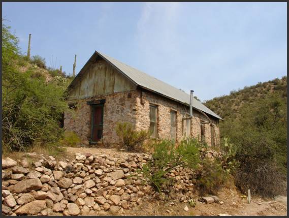
Figure 9, Flood Wall at O'Brien Gulch
O’Brien Gulch rises more than 650 feet above the point of
this photo and descends another 430 feet to the
The next photo, Figure 10, shows a different type of dry stack wall. I had some difficulty deciding whether to call this as a “retaining wall” or a “terrace wall’, but finally settled on the first term for two simple reasons: (1) this dry stack was built to prevent sedimentation from the uphill side and (2) there is no lower wall.
Figure 10, Retaining Wall at Constellation
If you have ever visited Constellation you already know that no buildings remain at this site. As famous as Constellation is to the history and legend of the Black Rock Mining District, there remain only a few walls and two piles of broken glass from the saloon. Nevertheless, the wall in Figure 10 illustrates another useful function of dry stacks. In this case, the wall was built to prevent sedimentation from the uphill slope so that a flat area below could be maintained (left). This site would have accommodated a relatively large structure for the era, possibly 40’ by 20’ in size. The wall shows careful construction and features a smooth, straight face and a relatively tight fit. The stones at the right edge of the photo strongly suggest they were shaped by stone masons.2
You might think this site has always had a gentle downward slope to the left, but it is easy to be misled by surface features. Persistent sediment flow from above the wall has undoubtedly contributed to the sloping that you see here. I would imagine that one or two additional courses of rock are below surface at the (visible) base of the wall.
The exact founding date of Constellation is unknown to me, but was probably in the early 1880’s (if not before). Stage coaches and freight wagons were passing through this location on their way to the Gold Bar Mine and points east by that time. This retaining wall could, therefore, be up to 130 years old.
What Do These Photos Tell You?
1. Walls that were required to bear heavy loads, such as Figures 2-4, were typically constructed using material that was shaped by masons to ensure strength and durability. Dry stack walls of this type appear to have been made of materials that were not local to the mine or settlement.
2. Dry stacks that were made from local material, such as Figures 1 and 6, 7 and 9 demonstrate a high level of craftsmanship in the careful placement of stones and provided a high degree of structural integrity. These walls could not have supported the heavier weight and stress that would have been required at a mine site, but they have survived to present time.
3. Figure 8 shows that craftsmanship is more important than beauty! While this appears (from an aesthetic point of view) to be a haphazardly built wall, it has endured the test of time.
4. The kiln in Figure 5 shows that sufficient heat can be generated to melt gold and silver ore using rock structures. We intuitively understand that a rock fireplace can radiate warmth in a house or cabin; but this simple, open-air application of dry stack walls provided economic utility as a smelter.
5. The wall in Figure 10 was not a load bearing structure. Its sole function was to prevent (or retard) sediment from uphill runoff.
In Part Four of this series we will examine a variety of dry stack
terrace walls that can be observed at old mines and settlements. The final article (Part Five) will deal
exclusively with rock cabins. (I have decided to expand this series of articles
to five segments (rather than four) in order to provide a more comprehensive
treatment of the remaining two topics.
Notes and References
- The original stamp mill structure contained a more extensive wood framing than is shown in this photo. Current owners of the Gold Bar Mine have removed the remaining wood structure and appear to be repairing this portion of the mill site.
- The
photo in Figure 10 is on the south side of
American Pioneer & Cemetery Research Project
Internet Presentation
Version 041609
WebMaster: Neal Du Shane
Copyright © 2009 Neal Du Shane
All rights reserved. Information contained within this
website may be used
for personal family history purposes, but not for financial profit of any kind.
All contents of this website are willed to the American Pioneer & Cemetery
Research Project (APCRP).
HOME | BOOSTER | CEMETERIES | EDUCATION | GHOST TOWNS | HEADSTONE
MINOTTO | PICTURES | ROADS | JACK SWILLING | TEN DAY TRAMPS