American
Pioneer & Cemetery
Research Project
Internet
Presentation
Version 050710

AND GILA CITY - DOME
Yuma County, Arizona
By
Kathy and Ed Block
APCRP
Historians
To View the Roster of names interred in the Dome Cemetery
Sometimes discoveries
of old cemeteries are accidental. I (Kathy) had been scrolling thru TerraServer
maps of the Gila Mountains north of Yuma looking for possible gold prospecting
areas.
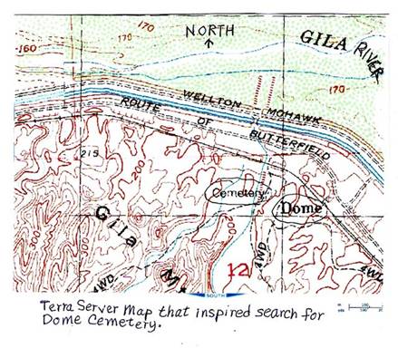
Suddenly at the site
of Dome, the word "cemetery" leaped out, calling for further
research. The Internet yielded nothing, nor did various reference books on mining
placer areas in Arizona. Ed and I were drawn to the area not only to explore,
but find that cemetery!
During
our trek at the end of January, 2009, Dome and Dome Cemetery proved to be very
difficult to locate. We drove east along the south side of the Wellton-Mohawk canal on the track of the old Butterfield
Stage Overland Mail Route, from Highway 95.
Turn east just south of mile marker post #38 with a gravel pit to your
left (north), a row of mailboxes and the railroad to your right (south) and
"Martha's" on west side of Hwy. 95, slightly to the south.
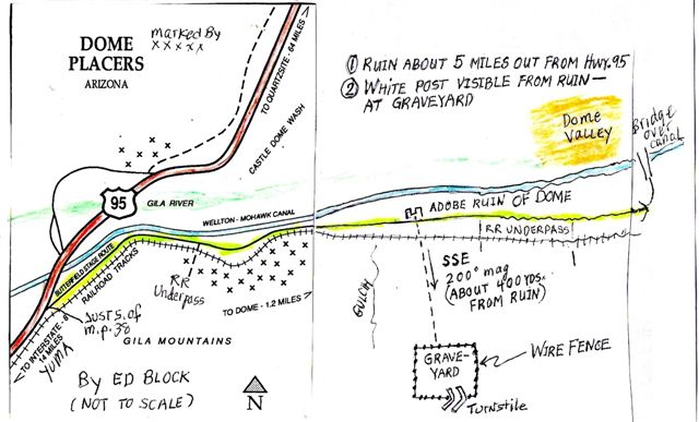
Drive east on the
slow and rough dirt road that meanders along with the canal on your left and
the railroad on your right, over steep hills, sometimes muddy areas, branching
routes, for about 5 miles to the site of Dome. We were able to locate the ruins
using a photo from a ghost town web site and DeLorme
maps supplied by Neal Du Shane. These maps proved invaluable later for finding
our way back to Highway 95 from the east end of the road!
En route to Dome we
looked for famous Monitor Gulch and the possible Gila City site where the gold
rush in this area began. An enclave of old trailers, rusting cars, barking
dogs, and junkyard appearance seemed to be in the correct area, but the general
scene discouraged further investigation.
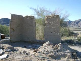
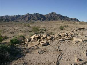
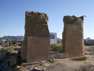
About one to two
miles further east we located the adobe ruins of Dome. There's no visible sign
on the site that says "Dome".
|
|
|
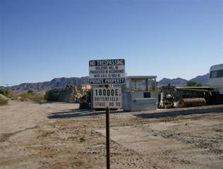
with NO TRESPASSING sign
next to them, on the left (north) side of the road. Ed and I walked south
across the railroad tracks towards the Gila Mountains.
Ed spotted a fenced
enclosure by a white post to the south/southeast by a white post. He went there
and photographed what is almost certainly the Dome Cemetery. The BLM posted a
sign and may have built the enclosing barbed wire fence and turnstile. Only one
possible grave site was visible. This may not be a feasible site for
restoration work. It is not particularly worth the effort to reach, in our
opinion. Just past Dome, continuing east, there is a railroad underpass that
gives access to a network of 4x4 roads, including one that goes to the cemetery
site. Ed walked the 1/4 mile each way from the ruins.
|
Figure 1864 |
Figure 2 - 1865 |
|
Figure 3 – 1866 |
Figure 4 - 1867 |


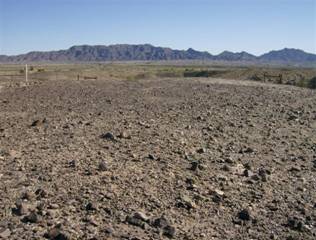
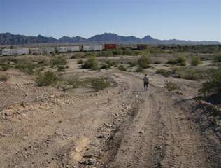
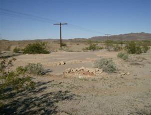
Figure #1864 one
possible grave; Figure # 2 - 1865 BLM sign and turnstile; Figure # 3 - 1866,
looking inside fence towards the Gila Mountains to the south. Figure # 4 - 1867,
road to cemetery, going towards ruins.
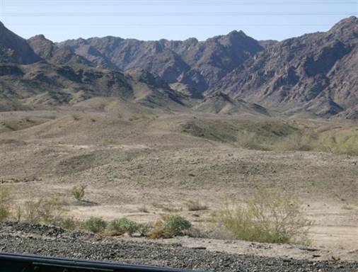
Figure
# 1869
Figure # 1869 is a long
shot of white post, looking towards mountains, looking at the terrain towards
the cemetery.
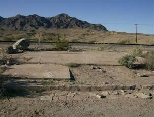
There are various
ruins on both sides of the railroad track that are all that remains of historic
Dome. Cracked concrete pads, crumbling foundations, and rusting cans in washes,
broken glass, bits of metal give clues that people and buildings were once
here.
|
Figure 5 – 1858 |
Figure 6 - 1860 |
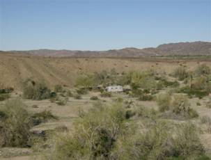
From a plateau SW of
Dome we spotted a large gulch running north from the Gila Mountains. An old
trailer was parked in it near the mouth. We haven't been able to find the name,
could it be Monitor Gulch?
|
Figure 7 – 1862 |
|
Continuing east, we
eventually found a rickety wooden bridge over the canal. This let us work our
way west towards Highway 95 on a series of minimal dirt tracks along the north
side of the canal, past the swampy Gila River and marginal truck farms, until
we reached pavement and streets shown on the DeLorme
map. We recognized one street from a route taken previously to hike in the Muggins Mountains, and then were able to reach Highway 95.
We DO NOT recommend reaching Dome
from the west going east. It's much easier to locate Dome traveling east from
Highway 95. We were pleased we were able to locate Dome and its cemetery. We
were pulling a small travel trailer with our Toyota 4x4 on these bad roads,
which was an additional travel challenge!

The history of this
area reflects the discovery of rich gold placers in and around Monitor Gulch,
which emerges from the Gila Mountains to the south. There are two different
stories of their discovery involving a colorful Texan named Colonel Jacob Snively. He led a party of prospectors to this area, which
is about 20 miles east of Yuma and the junction of the Gila River with the
Colorado River, in 1858. One account claims Henry Birch, a member of the group,
discovered a nugget there near the Gila River. The other account says that
Colonel Snively was given credit as the leader, and
supposedly, "swished the water from the Gila River in his pan and saw gold
nuggets glittering in the sun!"
A note about Colonel Snively: He was a veteran of the Texas War of Independence
and had been Personal Secretary of General Sam Houston. After further
adventures, he met a sad end. In 1871 he was shot off his horse during an
Apache attack at White Picacho Mountain. Wounded and
abandoned by his companions, he was captured and tortured to death. A few days
later his old friend Jack Swilling, part of his original party, returned to the
site to bury the remains. Seven years later Jack Swilling felt haunted by
thoughts of the hasty burial. Jack traveled to White Picacho
Mountain to claim the remains for reburial in the backyard of Swilling’s Stone House in Black Canyon City. While in this
process, a stage was robbed and Swilling was blamed. After Jack Swilling died in the Yuma County jail
awaiting trial, the actual hold-up men were identified and Swilling's
innocence was established too late.
A good write-up on an
APCRP
project to erect a monument at the graves of Jacob Snively
and Jack Swilling can be found on: http://www.apcrp.org.
Back to Gila
City! Gila City emerged overnight as
eager prospectors rushed to the site. These placers were worked for eight years
by thousands of miners. They worked the plateaus and canyons using everything
from skillets to wash pans. They were panning out $20 to $125 a day in gold
dust, and nuggets weighing up to 22 ounces each were deposited at the Wells
Fargo office in Los Angeles. Lieutenant Sylvester Mowry,
an early adventurer, found about 100 men and several families working the
gravels at Gila City and saw more than $20 washed from 8 shovelfuls of dirt - a
lot of money in 1859. Some miners were
paid $3 a day plus board to work lower grade deposits.
In 1864 J. Ross
Browne wrote: "There was everything in Gila City except a church and a
jail which were accounted barbarisms by the mass of the population. When the
city was built, bar rooms and billiard-saloons opened, monte
tables were established and all accommodations for civilized society placed
upon a firm basis. The gold placers gave out and the remains were washed away
by a flood in 1862. All that remained of the metropolis of Arizona consisted of
3 chimneys and a coyote."
The post office was
established Dec.24, 1859 and discontinued July 14, 1863, one year after the
flood.
Another development
bringing growth to this area was the Butterfield Overland Mail Route, shown on
the map between the present canal and the railroad. This is the route we drove
to reach Dome. In October 1858 the route was officially opened in St. Louis,
Missouri, to wind 2,800 miles through parts of Arkansas, Oklahoma, Texas,
Southern New Mexico, Arizona, present day Yuma, and on into California, ending
in San Francisco. John Butterfield and associates were awarded the mail
contract in 1857 as a link between the east and the west. Some of the
stagecoaches were pulled by mules instead of horses here.
Historic stops in
Arizona starting at Yuma, going east to Apache Pass (Fort Bowie) are listed
near Gila City. (The old Overland route doesn't always follow modern roads.)
Distances between stops going east were: Yuma (start); Desconso
Station 14 miles east; Gila City, 8 miles east; Rattlesnake Station, 7
miles east; Mission Camp, 3 miles east, ending at Apache Pass (Fort Bowie) with
23 more stops in- between, including Tucson. The total distance from Yuma to
Apache Pass was roughly an amazing 426 miles.
A fascinating account
by E. Conklin, written in 1877, called Picturesque Arizona: Being the
results of travels and observations in Arizona during the fall and winter of
1877."
One chapter tells
about "Gila City: A Frontier Hotel." (Remember the
city was flooded out in 1862, some 15 years earlier.) The writer, who
was a member of an ambulance corps and commissary depot traveling east from
Yuma towards the Santa Rita Mountains, described what remained of Gila City in
eloquent prose: "The remnants of an ambition often revived, and as often
overthrown, a living skeleton of a miner's hope and fancy, and the scene
evidently, in days gone by, of all the vicissitudes of a miner's and
prospector's life on the borders of our country. In 1861 the population of this
city numbered about twelve hundred persons. Today it is composed of a stable
for the stage company's vehicles and animals, a corral for sheep or stock, a
square box-like building built of mud, one story high, and called the
"Gila Hotel" and a kennel for the big ferocious dog who kept
suspicious-looking stragglers and Indians away. The census of this city, taken
while there was just - let me see-the hotel keeper and his son - two; a man to
attend to the stage horses-one; and Indian Squaw, boy and papoose-three; three
dogs-three; making in all 9 living beings."
Then, later, "Nothing
exciting disturbed the quiet of the place at the time of our visit. Only one
man had been shot the day before one arrived, and the perpetrator was then off
in the mountains, looking for more gold heaps."
Accomodations were very primitive.
It cost the travelers $3 each for supper, lodging and breakfasts. "This is
the first intimation I have made of the costs of traveling in Arizona . . . don't
go to Arizona without first reckoning up the costs." The food was spread
on the ground and travelers sat and slept on the ground on hay they gathered
from the corral. "Each grabbed an armful of hay and proceeded back to the
scene of dirty frying pans, mutilated biscuit and broken cups of custard. We
spread our beds of straw and retired." They had a "goodly supply of
blankets."
The remains of Gila
City died out in the early 1870s, but the area came back to life again as a
rail siding named Dome, a mile or two east of Gila City. The Dome post office
was established in 1892, and the town's residents enjoyed mail service under
the city names of Dome, Gila, and Monitor during the periods that the town had
mail service.
Dome became a stop on
the Butterfield Stage line, replacing Gila City and supposedly drew shipping
business away from Castle Dome Landing, so much so that the establishment of
the Dome RR siding was probably what caused the town of Castle Dome Landing to
be abandoned. Dome slowly died the "slow death of other boom towns"
as the placer gold deposits were depleted.
The post office closed in 1904.
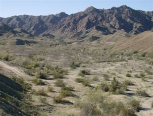
Today, all that
remains of Dome is a group of trailers, machines, trash, buildings, behind the
ruins of the adobe building, on the north side of the road. Looking south
toward the Gila Mountains you see a few mining claim stakes, various 4x4 tracks
going to the mountains up various washes and gulches, and the object of our
quest, the forlorn little cemetery, with an unknown number of burials, perched
on a slight hill amid grey gravel with a few scraggly plants to relieve the
starkness of the terrain.
|
|
|
Ed raised a question.
What happened to what would logically have been a cemetery to serve Gila City
and its large population of miners and their families? Did it vanish in the
flood that destroyed the city? Were graves moved somewhere else? And why is
only one burial apparent at the cemetery at Dome? No answers have been
suggested in my research on Gila City and Dome.
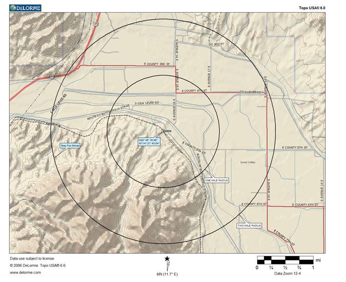
GPS
Coordinate: N32* 45’ 18.48", W114* 21' 43.54"
Map
by: Neal Du Shane
American
Pioneer & Cemetery
Research Project
Internet
Presentation
Version 050710
WebMaster: Neal Du Shane
Copyright © 2009 Neal Du Shane
All rights reserved. Information contained within this
website may be used
for personal family history purposes, but not for financial profit of any kind.
All contents of this website are willed to the American Pioneer & Cemetery
Research Project (APCRP).
HOME | BOOSTER | CEMETERIES | EDUCATION | GHOST TOWNS | HEADSTONE
MINOTTO | PICTURES | ROADS | JACK SWILLING | TEN DAY TRAMPS