HOME | BOOSTER | CEMETERIES | EDUCATION | GHOST TOWNS | HEADSTONE
MINOTTO | PICTURES | ROADS | JACK SWILLING | TEN
DAY TRAMPS
American
Internet Presentation

Version 110807
Table of Contents
(Click on hyperlink below – go directly to subject)
Arizona Pioneer &
Cemetery Research Project
Constellation, AZ Photograph
- 1909
Constellation, AZ Area Map
Pre-1893
Post Card mailed last day -
January 31, 1939
Monte
Cristo Mine – Early photograph
Monte
Cristo head frame and lift house
Constellation Location
Documented
Constellation
Cemetery Documented
Roster
of Interred at Constellation Cemetery
Constellation, AZ
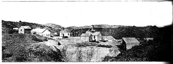
Photograph - 1909
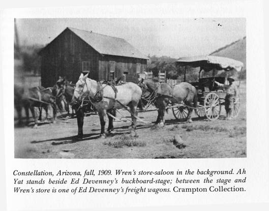
Figure 1. Photograph courtesy of the book “Deep Enough” by: Frank A.
Crampton
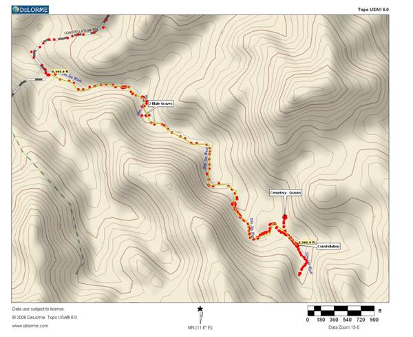
Constellation area map
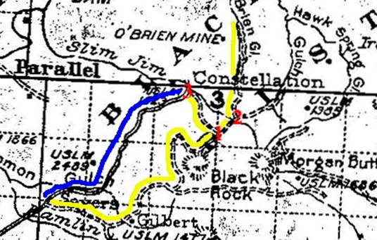
Figure 2. Constellation,
As indicated on the above map, the yellow line follows the
original road from present day
Due to the present day configuration of the primary roads in
the area, it’s easy to think the town of
We believe this Topographical Map (Figure 2) original was produced in the late 1890’s or very early 1900’s, with an updating and re-printing in 1904. Interesting to note on this map none of the mines are indicated. Mines by the names of Monte Cristo, Unida Group, Black Rock, Bloo Nellie, Black Rock, Key Stone, Wren were but a few. The O’Brien is indicated and the name later changed to the Gold Bar Mine.
Pat Ryland informs us that the name Constellation didn’t come from a mine name, rather it is believed to come from the term “Constellation of mines” in the area that the community served. There are vast amounts of unnamed placer and lode mines in the area.
It is documented that the
Constellation, AZ Area Map Pre-1893
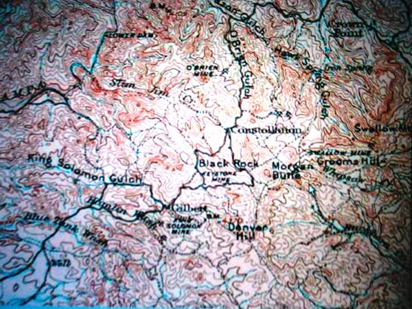
Figure 3. Pre-1893 Map of the Constellation area.
Courtesy:
Photo by: Neal Du Shane
This map is a photographic reproduction. Notice the trail
leading from King Solomon Gulch to the O’Brien Mine west of the old stage coach
road. The original road went from Wickenburg to Gilbert, Keystone Mine, north
to Constellation then followed O’Brien Gulch north. It should be noted that
this original old Stage Road is not the current
It’s been documented that the physical town of
Gold was discovered by James Mahoney at the Gold Belt
(O’Brien) mine in 1877. There is ample speculation as how the present day
Post Office
Constellations
Post Office was established on April 29, 1901. Wm. F. Roberts Post Master.
Closed Jan 31, 1939.
Post Card
mailed last day - January 31, 1939
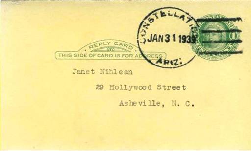
Figure 4. Post Card was mailed and post
marked the last day of operation at
Constellation, AZ Post Office.
Courtesy: Scott Rogers.
|
Constellation, |
|||
Business
and Structures
|
|||
|
Location: Where Constellation Road and Slim Jim Creek (SJC)
intersect, travel (SE) up SJC approximately 7/10th mile, foundations, mines,
stock corral, windmill mark the remains of Constellation, AZ. Lat. N34* 4'
8.00" Lon. W112* 34' 20.9" (WGS 84) Elev. 3,424 |
|||
|
|
|
|
Revised 6/24/07 by Neal Du Shane |
|
Business Type |
Structure |
Stories |
Comments |
|
|
|
|
|
|
Casino |
1 |
2 |
Largest building in Constellation
- 2 story, multi-room structure - located up in a dry wash. |
|
Rest
House - Cribs (several rooms) |
1 |
2 |
|
|
Dance
Hall |
1 |
2 |
|
|
Stage Station |
1 |
2 |
|
|
|
|
|
|
|
General
Store |
2 |
1 |
Located 100 yards from wash. Post
Office established April 29, 1901 Wm. F. Roberts Post Master. Closed Jan 31,
1939 |
|
Post
Office |
2 |
1 |
|
|
Saloon |
2 |
1 |
|
|
|
|
|
|
|
Stables –
building |
3 |
1 |
Up the
wash, beyond the large Corral |
|
|
|
|
|
|
Corral – Small |
4 |
|
Up the dry wash after the
2 story building |
|
|
|
|
|
|
Corral – Large |
5 |
|
Up the dry wash after the
Sm. Corral |
|
|
|
|
|
|
3 room
structure (House) |
6 |
1 |
Located
behind the General Store |
|
|
|
|
|
|
Chinese
Restaurant |
|
1 |
On |
|
|
|
|
|
|
Stage Coach & Freight |
|
|
Ed Devenney owned and operated |
|
|
|
|
|
|
Powhatten J. Wren is the only documented business man in
Constellation, he operated all business's. Owned all the buildings, inventory
and assets. He was assisted by Ah Yat a Chinese of more than ordinary
accomplishments. Plus at times the ladies would assist at the gambling tables
and at the Rest House. Powhatten is described as five-foot-three edition of a
Kentucky Colonel, he was embodiment of everything a Southern Gentleman was
pictured to be, including a well-groomed mustache and goatee, his especial price.
He wore high leather boots, black well-creased trousers, and a cutaway
morning-coat; under the coat was a cartridge belt with a holster that held a
Colt Frontier forty-four. Wren was never known to use the six-gun on a live
target, but on tin cans and bottles thrown into the air he was deadly. |
|||
|
|
|
|
|
|
|
|||
|
|
|
|
|
|
Source: |
"Deep Enough" by
Frank A. Crampton |
||
|
|
" |
||
|
|
|
|
|
|
Compiled and researched
by: Neal Du Shane - All Rights reserved © 06/24/07 |
|||
Figure 5.
Monte Cristo Mine & Milling
“The mine was originally worked by Mexicans who recovered large amounts of silver from ore that they mined and smelted. The kiln in which the ore was treated was a short distance down the gulch from their workings, around it were tens of tons of slag.---a couple of prospectors learned that they were not American citizens and therefore had no legal rights to the claim. --- and they exercised their legal rights by locating the claims and driving the Mexicans off after a couple of days of gun play but no shooting. The prospectors got what was coming to them and after several months, they found no signs of the area where any of it had came from. Apparently the prospectors owed Thayer money which they couldn’t pay----he took the claims over and the former owners departed.
“Deep Enough” by Frank A. Crampton pp152
Alternate names:
JULIAN MERGER MINING
AMETHYST VEIN
MILS NO: 365A
: TOWNSHIP 8 N RANGE 3 W
SECTION 4 QUARTER W2
LATITUDE: N 34DEG 03MIN 51SEC
LONGITUDE: W 112DEG 34MIN 28SEC
Original owner Ezra W. Thayer. He was a hardware merchant in
1926 C.C. Julian purchased the mine. Whenever he was asked about selling it he would say, “The Monte Cristo Mine is not for sale”.
1933 High tension was run from
The mine went into receivership in 1938 or 1939. Dr. N. H. Morrison purchased it.
The mine is 1,150 feet deep and had drifts at each 100’ level. Approximately 22,000 feet of tunnels. That’s over 4.16 miles of tunnels.
1970 The head shed and three surface buildings were destroyed by fire set by juveniles.
1972 The owner was listed as Perry Underwood. He also owned the Wickenburg Lumber Co. (I don’t know purchase date)
1976 The Goldex company from
9/2/1976 Goldex quit. They got the water down to the 800 foot level, put no levels were cleaned out.
1984 Test drilling was done at the Monte Cristo.
1984 Last entry in file at Dept Mines & Minerals W.K. Ranies looking for a mining engineer to supervise the de-watering and to reopen the Monte Cristo. He reported that his people have a lease-purchase agreement on the property and need an engineer with a “good resume” to satisfy the investors.
All information obtained from
AZ Dept of Mines and Mineral Resources as well as
Monte Cristo Mine – Early
photograph
Figure
6, Photograph courtesy of
the Arizona Mining Journal c. 1913
Monte Cristo head frame and lift house
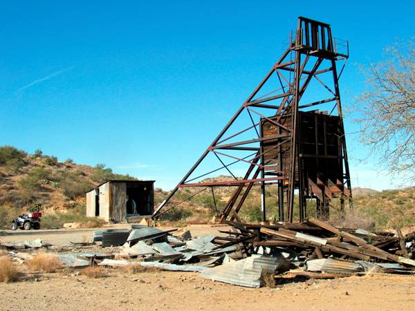
Figure 7, Monte Cristo Mine, head frame and lift house, c. 2006. Photograph by:
Neal Du Shane
In 2006 there isn’t much left of the former grand Monte Cristo Mine but
none the less an interesting stop to explore. Remember to take only pictures and
help preserve history for generation’s to come. The head frame and lift house
are the only structures remaining upright. There is a lot of interesting
history if you walk the area. Foundations of former structures dot the
landscape in all directions from the head frame. Needless to say this was a
very impressive operation in its day. By: Neal Du Shane.
Unida Group
Courtesy: Scott Rogers
Alternate Names:
Bloo
Nellie
Home
Patented
Claims MS 2489
Blue
Lead Group
MILS NO: 369B Past Producer
TOWNSHIP 8N RANGE 3W SECTION 8 QTR N2 Commodities: Cu (Sulfide)
Au
Ag
Cu (Oxide)
LATITUDE: 34DEG 03 MIN 31 SEC LONGATUDE:
112DEG 35 MIN 43 SEC
This property is located in the Black Rock District, 11 miles northeast of Wickenburg and is a parallel true fissure vein to the Electra vein and is between the Electra and Blue Lead properties, in an altered diorite dyke in a granite formation and consists of four full lode mining claims on the lead. Several shafts and cuts expose a quantity of high grade carbonate ore carrying good values in gold and copper. Owned by Geo. Margaritch and L.C. Nickerson of Wickenburg. (1905 Mines of Wickenburg)
Unida Mine Group
remnants
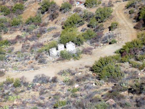
Figure 8. One of the structures at the former Unida Mine Group. Photo by: Neal Du Shane
Constellation Location
Documented
By: Pat Ryland
The place I know
Constellation to be, would be the red #2 on the topographical map (Figure 2.). Where
Slim Jim Wash crosses the old stage road. The stage road is the yellow line
you're talking about that goes thru Keystone & O'Brien Gulch. We have
walked following the old stage road from Keystone to Constellation but it's
much faster & easier to go up Slim Jim Wash. Just walk up Slim Jim Wash for
a mile or maybe a little more. When you get to the bigger wash there should be
a windmill with an old can/glass dump close by. All the glass is broken
unfortunately. If you look around under the tress along the edge of the wash
there are a few remnants of foundations. Or at least there was the last
time I was there, probably five years ago (2002).
The
late Dana Burden also said that this was the location of Constellation because
he had seen photos that were donated to the
Constellation wasn't a mine. My understanding is that the town was called that
because there was a constellation of mines all around it. But the Monte Cristo
seems to have often been called Constellation so I think that's why it gets a
little confusing.
When it cools off in the fall (2007) I'd be willing to show you where it is.
Hopefully you don't walk too fast! Also, have you talked to Joe Stevens? He
lives in Wickenburg & knows a lot about the Monte Cristo Mine & all
around that area.
Constellation Cemetery
11/08/2007 found
Pat Ryland and myself venturing to the Ghost Town of Constellation up
History regarding
this town has been sketchy as it would seem all reference points were using the
current day
The original Road
went through the not Ghost Towns of Camp B. King Solomon Mine, down to Gilbert
then east to Keystone. At this point after Keystone, turning north to Constellation
and
Venturing the 1.2
miles up
Upon arriving at
the Ghost Town of Constellation we researched many of the possible locations
that looked like they were inhabited at one time.
Roy Williams of the
Williams Ranch, brought up a very valid point: During the hard times of the
depression in the 1920’s and 30’s many of the old wood structures in these
Ghost Towns were dismantled by “City Folks” down on their luck, the wood taken
to town and reused in habitats there.
This may be the
explanation why so many nails are laying about these old structure foundations.
Surmising a
community that survived for some 50 years would have had a death or two. None
of the history we have researched ever indicated or mentioned a “
Such was our quest
to the Ghost Town of Constellation to see if we could identify the
Coming up
Figure 9.
Roster of Interred at Constellation Cemetery
|
|
||||||
|
|
||||||
|
|
||||||
|
|
|
|
|
|
|
|
|
|
||||||
|
|
|
|
|
|
|
|
|
From Wickenburg - |
||||||
|
|
|
|
|
|
|
|
|
Latitude N34 03.819, Longitude W112 33.081 (+ - 12) (WGS84) Elev. 3,572 |
||||||
|
|
|
|
|
|
|
|
|
|
Burials = |
6 |
|
|
|
11/8/2007 |
|
Marker |
SURNAME |
FIRST NAME |
MIDDLE NAME |
BIRTH DATE |
DEATH DATE |
COMMENTS |
|
|
|
|
|
|
|
|
|
Rocks |
DOE |
John |
|
|
|
Adult
male |
|
Rocks |
DOE |
John |
|
|
|
Adult
male |
|
Rocks |
DOE |
John |
|
|
|
Adult
male |
|
Rocks |
DOE |
Jane |
|
|
|
Adult
female |
|
Rocks |
DOE |
Johnny |
|
|
|
Child
male |
|
Rocks |
DOE |
Janny |
|
|
|
Child
female |
|
|
|
|
|
|
|
|
|
|
6 |
|
|
|
|
|
|
|
|
|
|
|
|
|
|
NOTE: |
1.2 miles up |
|||||
|
|
|
|
|
|
|
|
|
Contributor: Neal Du Shane |
||||||
|
|
|
|
|
|
|
|
|
Historian: Pat Ryland, Neal Du Shane. |
|
|
|
|||
|
|
|
|
|
|
|
|
|
Material may be
freely used by non-commercial entities, as long as this |
||||||
|
message remains on
all copied material, AND permission is obtained from |
||||||
|
the contributor of
the file. |
|
|
|
|||
|
|
|
|
|
|
|
|
|
These electronic pages
may NOT be reproduced in any format for profit |
||||||
|
or presentation by
other organizations. Persons or organizations |
||||||
|
desiring to use
this material for non-commercial purposes, MUST obtain |
||||||
|
the written consent
of the contributor, OR the legal representative of |
||||||
|
the submitter, and
contact the archivist with proof of this consent. |
||||||
|
|
|
|
|
|
|
|
|
|
|
|
|
|
|
|
|
|
|
|
|
|
|
|
|
This file was contributed for use of |
||||||
|
Contributor/Archives by: Neal Du Shane - All rights reserved |
||||||
We have been unable
to find documentation as to names of those interred and there is no headstones
on any of the graves. It is very doubtful there were ever headstones as we know
them today. Very likely rocks outlined the grave and a wooden cross was used.
After 100+ years the cross has decayed leaving no trace of a grave other than
the rock outline. Cattle roam this area and are notorious destroyers of
headstones and markers. Our research continues.
Editors Note: Research on the Ghost Town of Constellation
continues, as well as information on the general area. Our research confirms
the location of the Ghost Town of Constellation to be at a point up
Acknowledgements: Pat Ryland, Allan Hall, Pat Ryland, Scott
Rogers, Roy Williams, Doug Miller, for their continued support and dedication
to research and preserving historical information.
APCRP Internet Presentation
All Rights Reserved, © 2007 by Neal Du Shane
WebMaster: Neal Du Shane
HOME | BOOSTER | CEMETERIES | EDUCATION
| GHOST TOWNS
| HEADSTONE
MINOTTO
| PICTURES
| ROADS
| JACK SWILLING
| TEN DAY TRAMPS