HOME | BOOSTER | CEMETERIES | EDUCATION | GHOST TOWNS | HEADSTONE
MINOTTO | PICTURES | ROADS | JACK SWILLING | TEN DAY TRAMPS
American Pioneer
& Cemetery Research
Project
Internet Presentation
Version 110719
BISHOP FAMILY CEMETERY
CIBOLA, La Paz County, Arizona
N33 18 55.4, W114 39 50.29 (WGS
84)
By Kathy Block
APCRP Booster and Historical
Staff
|
Bishop Family Cemetery, on L. Bishop
Ranch. Photo courtesy: Author |
While
researching the area near Cibola National Wildlife Refuge to the north of
Cibola settlement and Trigo Mountain Wilderness to the south of Cibola, the
word “Cemetery” appeared on an old Topoquest map! The cemetery was a small,
private, historical burial site for members of the Bishop family. The Bishop
family has many links to the development of this agricultural community in an
unknown corner of western Arizona.
The
first white visitor to the area was an intrepid Spanish ship captain named
Hernando de Alarcon, from Colima, Mexico, who was supposed to bring supplies to
Coronado by sea in 1540. He commanded three supply ships and sailed up the Gulf
of California from Mexico. They became stranded on sand bars where the Colorado
River flows into the Gulf. On June 26, 1540, he named the Colorado River “Rio
de Buena Guia” or “River of Good Guidance.” He came up the Colorado as far as
Yuma in his flag ship, and then may have traveled as far north in a rowboat to
the Gila River. He sought Coronado, who was actually far to the east looking
for the “golden city of Cibola.” Alarcon was always heralded by a drummer and
trumpeter and claimed he made “excellent friends with the tall Yuma Indians.”
Cibola
was part of the ancestral and traditional home of the Yuma tribes of the
Colorado, the Mohave and Quechan. These people farmed the river flood plain,
which flooded annually, depositing rich soil for crops. After each harvest, the
people left the river to hunt and gather wild plants in nearby desert uplands.
They returned to the river after spring floods had subsided. Little physical
evidence of their dispersed villages is found due to this flooding.
The
name Cibola was given to the rich agricultural lands and valley along the
Colorado River. An 1899 article in the Yuma
Sun glowingly reported:
“Cibola
Valley – so called by the original projectors of enterprise now nearing
consummation, after the theme of the Zuni villages of the 16th
century, contains 20,000 acres of as fertile irrigable land as there is under
the sun. 5000 acres susceptible to annual overflow from the silt-laden
Colorado, and 5000 acres too high to be watered by gravity, making 30,000 acres
in all, the major portion of which will very soon blossom under the influence
of the application of water and all of which will at no distant day feel the
skill of the farmer's hand.”
“Cibola” was supposedly the
“Chi-vo-la” of Fray Marcus of Nizza, which equals the Zuni name for themselves, namely Shivona, Sinbwina. The last pueblo of the Zunis was called Cibola or
Granada, and was first visited by Coronado and other Spanish explorers in 1540.
Another
glowing report, in an 1899 The Arizona
Sentinel, came from a wealthy man who was one of 13 “agriculturalists” from
California who had shown enthusiasm about the prospects of the area for growing
oranges, walnuts, grapes, apricots, beets, and alfalfa. Others wanted to bring
cattle. The article predicted, “It will not be long before the valley will
teem with palatial homes, luxuriant grain fields, beet fields, and orchards of
every semi-tropical fruit.”
An
example of cattle coming to the area was in an article about Angela Scott (born
in Yuma 1881). Her father in 1882 brought cattle down the river from Ehrenburg
to Cibola. Then, in the early 1900s, he moved them to Tyson's Wells
(Quartzsite) and finally to Wenden.
Another
account told of William B. Roods, of Death Valley '49ers fame, who had a herd
of 4000 cattle to furnish beef to forts, stations, miners, and travelers near
Cibola. He drowned in early 1870 while attempting to cross the Colorado River. No
mention was made about the fate of these cattle!
One
of the pioneer families in the Cibola valley was that of Louis W. Bishop, born
1850 in Missouri, died 1919 in Cibola. He and his older brother came to Cibola
by wagon from San Diego across the Imperial Valley in 1898, at the beginning of
the boom. Bishop and other settlers immediately began to build a canal to bring
water into the valley to irrigate crops.
He
and his neighbors filed for their Homesteads in late 1910, witnessing each
other's notices. The notice, published in several local papers, for Louis W.
Bishop read:
03119
Notice for Publication
Department of the Interior
U.S. Land Office at Phoenix,
Arizona, November 21, 1910.
Notice
is hereby given that Louis W. Bishop of Cibola, Arizona, who, on November 11,
1901, made Homestead Entry No.03119 for NW1/4 Section 21, SW1/4, NW ¼,
W1/2-W1/4 Section 13, Township 1 South, Range 24 West. G and S.R. Meridian, has
filed notice of intention to make final five-year proof to establish claim to
the land above described before Charles H. Utting, Clerk of the District Court,
at Yuma, Arizona, on the 27th day of December, 1910. Claimant names
as witnesses: Gus Livingston, of Yuma Arizona; W.E. Marvin of Yuma, Arizona;
Mrs. T.M. Hart of Cibola, Arizona; Adolph W. Frankenberg, of Cibola, Arizona. FRANK
H. PARKER, Register, Nov. 24, 1910.
There
were many similar notices filed in newspapers for homesteads in Cibola that
year.
A
year later, an interesting letter to the Arizona
Sentinel and Yuma Weekly Examiner proclaimed:
Turlock, Cal. Dec.4, 1911
Editor Arizona Sentinel, Yuma.
Please give this letter to a live real estate
agent. I am in the market for any amount of 2,500 acres of valley land located
in the Cibola valley, Yuma County.
There is about one half of that valley patented
land, and patented land is what I want.
I have been over it all and I know it well as I
have been in the valley on two hunting trips. I am in the Angora goat raising
industry and I think that it would be a good place for them.
The price must be cheap and the terms easy.
Let me hear from you at once as to any proposition
you have. State the legal description of the land as I have a map and I can
tell where it is located.
Yours truly, C.H. McDonald.
In
March 1914, the Arizona Sentinel and Yuma
Weekly Examiner reported glowingly about the irrigation projects.
There were as many as 14 men working, and the field work was done. Cibola
valley had about 100 inhabitants. The valley was as rich as the Yuma valley.
But, “There has hardly been any development done in the Cibola valley. The
river overflows each year and leaves rich silt behind.” R.L. Morton, in
charge, stated that as soon as the number of acres of the valley was determined,
he would be able to determine the number of canals and levees needed.
The
canal to bring water from the Colorado was to be 16 miles long, 12 feet wide
and 4 feet deep. Then, after only 2 miles were completed, the project ended.
Some farmers built their own canals. A
2008 blog by Chea Lamb, a photographer, reminisced that her grandfather and his
brothers had a farm at Cibola and dug a 7 mile canal from the river to the
farm. The 2500 acre farm required removing many salt cedars. A ferry on oil
drums brought them across the Colorado. They grew cotton and alfalfa and ran
cattle in 115 degree heat! The children were required to help with planting,
weeding, and harvesting cotton and alfalfa, with no respite from the heat. Her
grandfather's two brothers, Marvin Thomas Arnett (b.3-15-1916) and Fred Gale
Arnett (b.8-7-1921) were killed in a plane crash on September 17, 1964, as they
were leaving the farm. Approximately 18 children were left fatherless. Her
grandfather witnessed the accident and pulled them from the burning wreckage.
He'd lost his best friends and partners, and eventually his farm. The brothers
were buried in the City of Mesa Cemetery, Arizona. The farm land is now part of
the Cibola National Wildlife Refuge. The salt cedars were removed, and cottonwoods,
willows, and mesquites and native vegetation have reclaimed the fields.
|
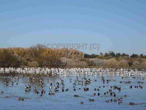
Canadian
Geese and Snow Geese at Cibola National Wildlife Refuge on reclaimed farm
land. Photo courtesy: Author |
There
was a steamboat landing called Cibola Boat Landing in the late 1890s, where
river steamers unloaded freight and took on wood for their boilers. These boats
traveled about 86 miles upriver from Yuma. After 1900 a ferry crossed the
Colorado River to Blythe at this site, known as the “old Rhodes Ranch.”
Cibola
in the early 1900s was fairly prosperous and even had a stage office/stop. Ehrenberg
to the north was a shipping point for most freight for Prescott, Wickenburg,
and points east and had a general stage office of the California and Arizona Stage
Company. This company was sold out, though, in 1878 to competitors. There was
an early stage line that served settlements along the Colorado River north from
Yuma and may have briefly come to Cibola. In 1881 Patrick Hamilton in “The
Resources of Arizona: A Manual of Reliable Information Concerning the
Territory”, enthusiastically wrote:
“Yuma
has a tri-weekly mail line to Castle Dome, Silver District, and Ehrenberg.
Nearly all these lines have comfortable coaches and good stock. Passengers will
find eating stations at convenient distances. The traveling is nearly all by
day, and no pleasanter trip can be imagined than a ride on the outside seat of
a Concord coach, behind a good team, over the ever-changing panorama of
mountain, valley, and table land which make up the bold outlines and wonderful
perspective of Arizona scenery.”
By
1930 although crops of cotton and alfalfa continued to be grown, the beekeeping
industry became a livelihood. In the
1930 Cibola census, forty people were listed. Five were bee keepers. Other
sources of income were: one proprietor and one laborer on the river ferry;
seven “cattle farmers”; three “cow punchers”; one mail carrier; one clerk at
the water works; one carpenter; and one lumber yard laborer. Six farmers were
bee keepers and raised cattle. The Bishop Family was listed as:
Bishop, Carrie J., Head of household, age 73,
widow, farmer
Joe, son, age 48, single,
mail carrier.
Robert, son, age 45, single,
farmer, cow farm.
Clark, son, age 42, single, bee keeper,
gen.farm.
Zella, daughter, age 38,
single, no occupation listed.
Charles, son, age 50,
single, cow puncher, range.
It is interesting to speculate why none of the 5 children were married! Did
they stay home to help their widowed mother on the family farm?
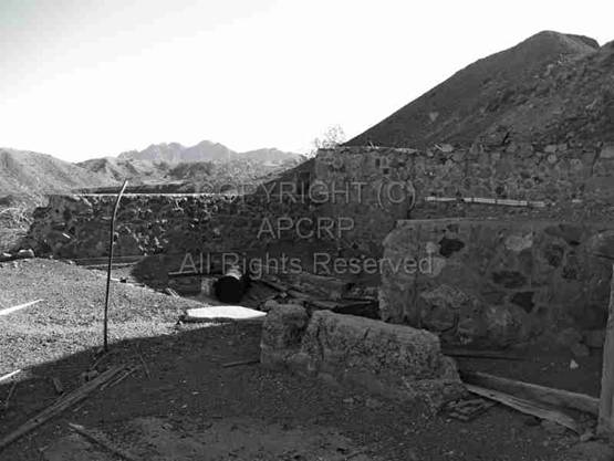
Mines
in the Trigo Mountains, southeast of the Bishop Family Cemetery, provided some
employment and a small amount of minerals. Original efforts in the 1890s were
on small gold veins and placers. There were only about 52 tons of mined gold
ore that yielded about 62 oz. of gold and 10 oz. of silver and about 323 ounces
of placer gold with minor silver. Manganese was mined in the 1950's after
buying stations were established for low grade material. About 7,000 long tons
of 40 percent or more manganese ore was mined. All operations were abandoned
and much of the ore processing facility was dismantled. Here's what is left,
reached by Hart Mine Road just 6 miles south of Cibola and Bishop Cemetery.
|
Remains
of a processing mill south of Cibola. Photo
courtesy: Author |
Imperial
Dam and Cibola Lake Reservoir flooded some of the land and produced swamps.
Part of the fields and canals now are the Cibola National Wildlife Refuge. It
was established in 1964 to restore and protect historic habitat and wintering
grounds for migratory birds and other wildlife. The 16,627 acres encompass both
the historic Colorado River channel, and canals built in the late 1960's.
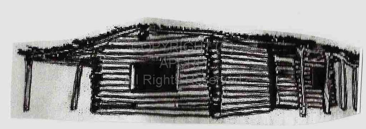
Carl
Bishop built a second cabin south of Hart Mine Road near Cibola Road. A BLM
plaque there reads:
“Cibola
Cabin”.
This historic cabin was built in 1910 by Carl Bishop as a second home. When the
river overflowed and it was no longer possible to live in the valley floor with
the farm and livestock, it was time to move to higher ground. This cabin was
built of cottonwood trees, which were planted in the early 1900s. This ample
building resource has now been replaced by tamarisk thickets, and the flooding
Colorado River is now tamed by dams, making the current landscape far different
from the one seen from this cabin's windows when it was first built.
This
structure is called a “dog trot” cabin because of the covered breezeway that
separates the two rooms. The “dog trot” generally separated the kitchen from
the living quarters to allow for a cooler living area and to prevent kitchen
fires from destroying the house's living area.
This breezeway, as the name indicates, also kept the house cool by
allowing air to circulate through the two halves.”
|
Artist rendering of Cibola
Cabin |
Louis
W. Bishop became the postmaster of the post office at Cibola, which operated
Jan. 23, 1903 to Sept.15, 1933. His son Joe was a mail carrier in 1930. The
post office was in a crude log shack and later became a cowboy's shack. This
photo from 1951 shows Louis' son Robert Hugh Bishop (1886 - 1968) standing in
front of the door, which had a slot in it for mail.
|
Bob
Bishop; age 65 in 1951, standing in front of Post Office. |
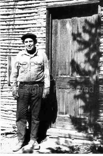
According
to a 1951 interview in Desert Magazine,
Bob noted that as the population of the valley shrunk, mail service was
stopped. Residents had to go north into Blythe, California for their mail. But
they defiantly marked their mail address as “Cibola, Arizona via General Delivery.”
There were not friendly feelings toward California then! Currently there are
about 200 residents in the Cibola area on scattered farms, in an area of 18
square miles, elevation 243 feet.
|
Map
of early postal rout to Cibola. Courtesy Mohave Museum of History & Arts. |
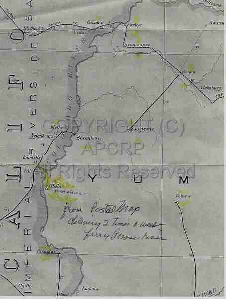
Note
other towns on this map that have been featured in APCRP articles: Polaris
(Kofa Cemetery), Laguna (Laguna Cemetery), Ehrenberg (Cemetery), Quartzsite
(Cemetery), and Swansea (Cemeteries). There was no highway south from
Quartzsite to Yuma and no bridge over the Colorado to Cibola
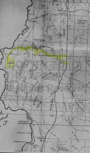
Residents
traveling to and from isolated Cibola and Yuma drove on about 100 miles of bad
roads. The route from Yuma was across the river on a bridge to California, up
to Picacho, then across again by ferry. Later, a road was built from 5 miles
north of Stone Cabin to the west from the old Yuma-Quartzsite Road, now Hwy.
95.
|
Map route to Cibola and the Mountains from Hwy.
95 south of Quartzsite, AZ. Courtesy Mohave Museum of History & Arts. |
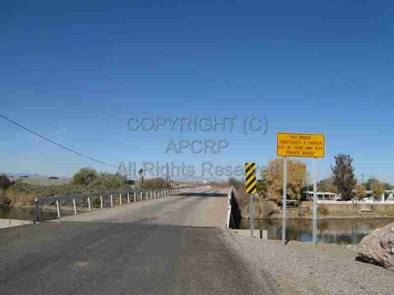
In
1957 a bridge was built by farmers across the Colorado River, about 15 miles
south of Ehrenberg at a ferry site. Local boaters were unhappy with “Farmer's
Bridge” because it was not very high above the river. In October, 2011, the
bridge was repaired and paved by the highway department at a cost of $980,000.
It was renamed “Oxbow Bridge”, and carries cotton gins, residents, and visitors
south to the Cibola National Wildlife Refuge, Cibola, Trigo
Mountains and Cibola Lake from Blythe, California to the north. The secondary
road is paved to the Cibola area.
|
Present-day
bridge across the Colorado River to Cibola. Note warning sign and marginal guardrails. Photo courtesy: Author |
Louis
W. Bishop and his family were involved in many events in Cibola, not all of
them positive. Louis Bishop was a
Justice of the Peace and his neighbor, Constable Frankenberg, had been one of
the witnesses to signing the homestead filing.
Famed Wyatt Earp, who had mines in the area to the north, was possibly
the sheriff of Cibola for one year in the 1890s. (Not confirmed.)
In
March, 1909, the Bisbee Daily Review
reported a bizarre string of events as, “Mix Up in Yuma Case is Puzzling:
Justice of Peace, Constables, Deputies and Specials Are Hauled into Court –
Justice before himself!” Very briefly, a neighbor named Stephan B. Sealy came
across HIS OWN two sons and a Mexican boy in the act of dressing a steer, which
they had killed from a herd of cattle over which there had been a lawsuit
between Sealy and his estranged wife. Sealy complained to a justice at Kofa,
who issued a warrant. The Cibola justice, Frankenberg, refused to serve a
warrant from another precinct. Then, Frankenberg was charged with contempt of
court and a warrant issued for HIS arrest. Sealy was appointed to go with the
constable and gather in the suspects! They weren't arrested and took their time
to go to Kofa. There were all kinds of mix-ups, but the situation was resolved.
A
year later, in June, 1910, this same Stephan B. Sealy was shot to death. Some
of the news account in the Arizona
Sentinel mentions Carl Bishop, one of the sons of Louis Bishop. This sad
story read in part:
“S.B.
Sealy, one of the best known and wealthiest citizens of Yuma County was shot
and killed at his ranch home in Cibola valley. Sealy has been in domestic and
financial difficulties for years; he has long been regarded as a man of
unbalanced mind, and from the meager details at hand, his tragic death seems to
have been due to an insane act.
Sealy
believed that his wife and other members of his family were conspiring with
others to defraud and rob him. With this idea predominant he last week
imprisoned one of his sons in a room and with a rifle went hunting for another
son, Toney, who in company with Carl Bishop and Leo Frankenburg, was trying to
evade his father's mad vengeance, and the three had combined also to release
the imprisoned son and disarm the crazed father. On the way to the Sealy home they encountered
the elder Sealy, who from ambush opened fire upon the party without warning.
The men returned the fire and Sealy fell, mortally wounded. He was shot through the neck and expired in a
few moments.
Mr.
Sealy with his family came to Yuma county from Oxnard, California, 14 years
ago. He possessed considerable wealth and invested his capital in the lands of
the Cibola valley, on the Colorado River....and owned most of the district as
well as the canal from which it was irrigated.
During
the greater part of his residence in this county he has been involved in litigation
and in family difficulties, which preyed upon and unbalanced his mind,
undoubtedly. A few years ago he was
committed to the asylum, but we believe was never closely confined, and was
soon released. He attributed many of his
troubles to his own family and affairs finally led to his wife securing a
divorce. With all his vagaries and troubles Mr. Sealy was looked upon as a
progressive citizen, a square man in business and in fact did a great deal in
the development of Yuma County.”
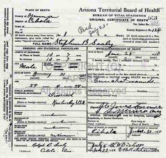
His
Death Certificate indicates burial in Cibola, but he is not buried in the Bishop
Family Cemetery. Maybe he was buried at his ranch? The DC was filed with
the local registry by Louis W. Bishop.
|
Copy of Death Certificate of S. B. Sealy |
Generations
of the Bishop family are buried in this small, neatly arranged cemetery located
just to the south of the present L. Bishop ranch. The graves are laid out in
progression from that of pioneering Louis W. Bishop and his wife to the latest
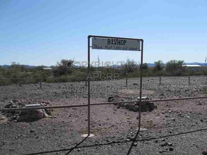
burial. An interesting sign is at the entrance:
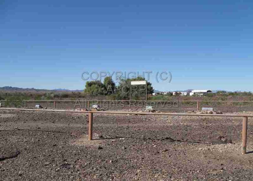
|
Bishop Family Cemetery Sign |
Pioneer Louis W. Bishop,
1850-1919 |
|
Plain headstones used with later burials. Note
sign on last burial. |
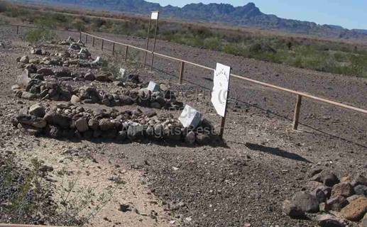
Overview of the nine grave
sites in the Bishop Cemetery. Photos courtesy: Author |
Over
the years, the style of headstones have changed. Most
had some genealogical information about the person buried there.
Here's
the list of burials in Bishop Family Cemetery, in order of their graves, with
#1 closest to you in this photo, extending to the most recent burial at the
farthest point. The cemetery measures 140 feet long by 39 feet wide inside the
fence, with the graves oriented to the Northwest.
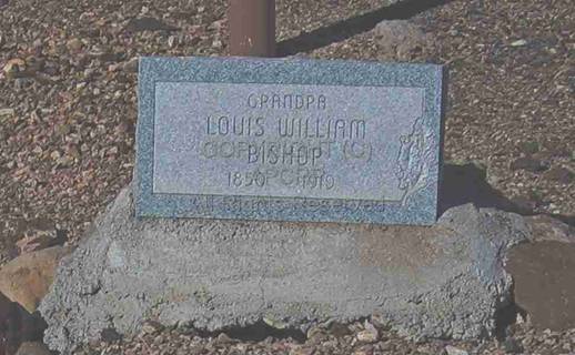
1. “Grandpa”
LOUIS WILLIAM BISHOP. Born June 1, 1850 in Missouri, Died March 13. 1919.
Burial place of Yuma was circled on the DC with an arrow, probably indicating
burial or reburial at Cibola. He was married and a farmer. COD: Cancer of
stomach. First grave. Note the elaborately decorated
headstone in photo.
2. “Grandma”
CARRIE JOSEPHINE STROH BISHOP. Born March 30, 1859 in
Illinois. Died August 28, 1937. Burial in Cibola. She was widowed and a housewife. COD:
Natural causes, old age. “no doctor present or no
justice the Peace here.” On the DC, Joe Bishop was the informant. Elaborately decorated headstone.
3. “Uncle
Joe” FRANCIS ALFRED BISHOP. Born May 1882 in Kansas. Died December 24, 1940. Buried in Cibola.
He was single, a rancher, and raised stock. His parents were Louis and Carrie
Bishop. Carl Bishop was the informant. COD: Occlusion of coronary artery,
diabetes mellitus. Elaborately decorated headstone.
4. “Uncle
Clark” CLARK STROH BISHOP. Born Jan.25, 1888 in San Diego, Cal. Died July 29,
1947. Buried in Cibola. He was single and a rancher.
His parents were Louis and Carrie Bishop. R.H. Bishop was the informant. COD: Myocardial
failure. Rheumatic heart disease. Elaborately
decorated headstone.
5.
CARL MASTON BISHOP. “Father of Joe, Louis, and B.L.” Born 1880 in Kansas. Died 1952. Buried in Cibola. Elaborately decorated
headstone.
6. ROBERT HUGH BISHOP. “Arizona
PV U.S. Army World War 1.” Born Aug. 8, 1886 in
Kansas. Died Sept.12, 1968 in Ehrenberg, buried in Cibola. Plain concrete headstone.
7. “Aunt
Zetta” LAZETTA BISHOP. Born June 2,
1890 in California. Died Nov. 19, 1970 in Ehrenberg.
Buried in Cibola. Daughter of Louis
and Carrie Bishop. Was single in 1930 census. Elaborately decorated headstone.
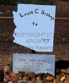
8.
Last burial. LOUIS CARL BISHOP. “A Good Friend.”Born Nov. 18,
1921. Died Jan.9, 2002. “PFC U.S. Army, World
War II.” Buried in Cibola. Plain
concrete headstone. Extra sign above grave.
(See photo).
9.
Pile of rocks with concrete base, but no headstone. Possibly
recent and waiting for headstone?
Bishop
Family Cemetery is located facing the L. Bishop farm. Any potential visitor
needs to contact the family in advance of any research visit, then needs to
check at the farm to gain permission to visit this cemetery. Keep in mind
trespassing is a felony in Arizona, if the property owners wants to file chargs.
The entry road
had a locked gate. This small cemetery is a well-preserved example of a
historic homestead cemetery.
DRIVING
DIRECTIONS
Directions
to Cibola from Blythe, California.
(A back roads access is approximately 30 miles of rough, dirt road, west from
Hwy. 95, 4 miles north of Stone Cabin, and signed “Cibola Lake.” It wanders
thru the Yuma Proving Grounds.)
Take
I-10 in California to the “Neighbors Blvd.” exit two miles west of Blythe.
Drive south 14 miles thru irrigated fields to “Farmers Bridge” (now Oxbow
Bridge) over the Colorado River. Follow
signs 4 miles further to the headquarters of the Cibola National Wildlife
Refuge. Continue south on paved Cibola Road another 7 miles and you will begin
seeing isolated farms. The turnoff for the L. Bishop ranch, on the west side of
Cibola Road, is just north of the entrance to a private gun club. Continue 6
miles further south to the Hart Mine Road which goes east to the mill
ruins. Another few miles past here is the
Cibola Cabin on a ridge on the east side of the road. Go 4 miles more to Cibola
Lake, formed by silting which choked the river off after the Imperial Dam was
closed in 1938. The road past Hart Mine Road becomes dirt and could be
impassible in wet weather. The Trigo Mountain wilderness can be accessed by the
next road to the east past Hart Mine Road. This is a very remote, isolated area
of Arizona!
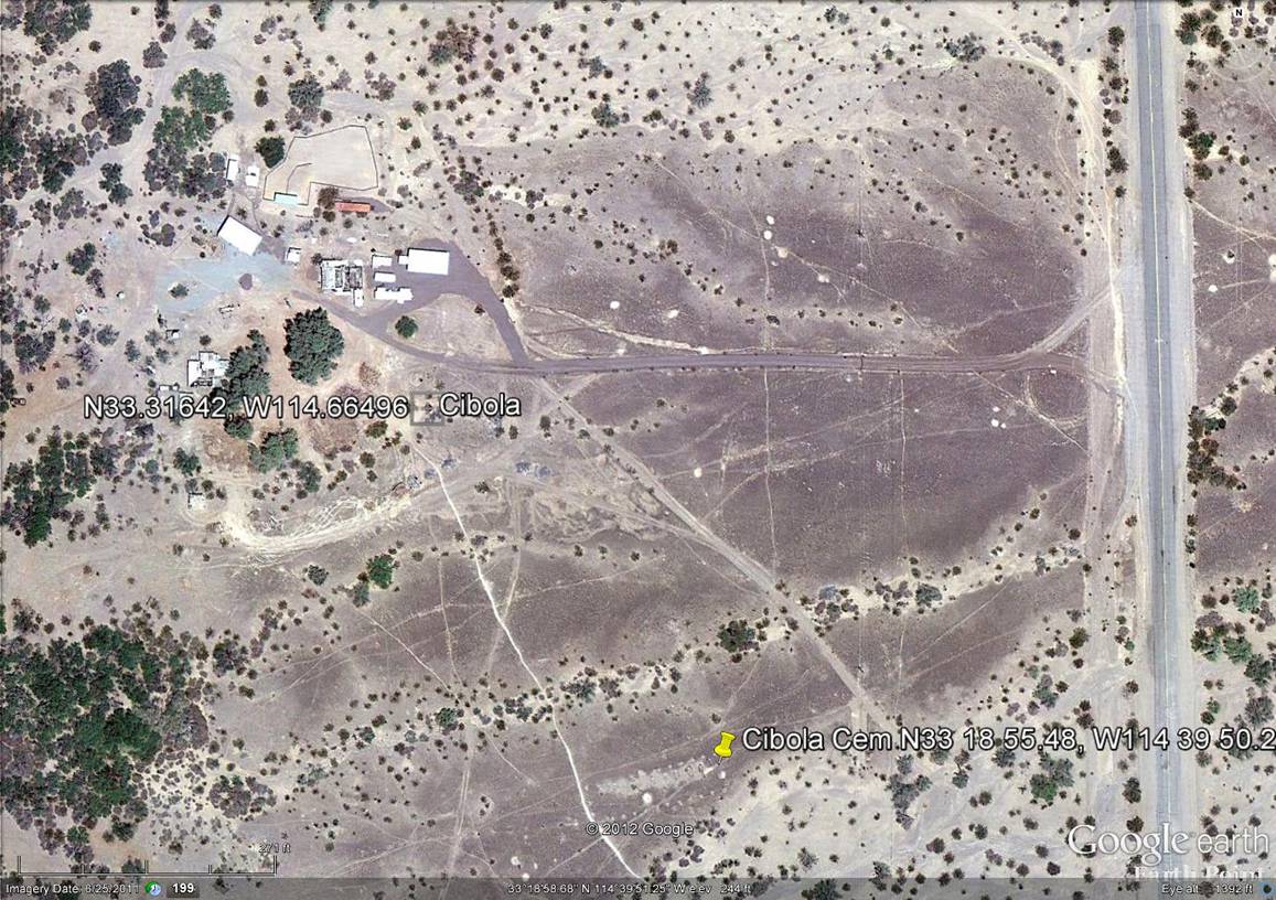
|
Satellite Image
courtesy Neal Du Shane |
American Pioneer
& Cemetery Research
Project
Internet Presentation
Version 110719
All rights reserved. Information contained within this website may be
used
for personal family history purposes, but not for financial profit or
gain.
All contents of this website are willed to the American Pioneer &
Cemetery Research Project (APCRP).
HOME | BOOSTER | CEMETERIES | EDUCATION | GHOST TOWNS | HEADSTONE
MINOTTO | PICTURES | ROADS | JACK SWILLING | TEN DAY TRAMPS