Internet Presentation
Version 121507
Black
Rock Mine
Monte
Cristo Mine
Cemeteries
An APCRP Work in Progress
By Allan Hall
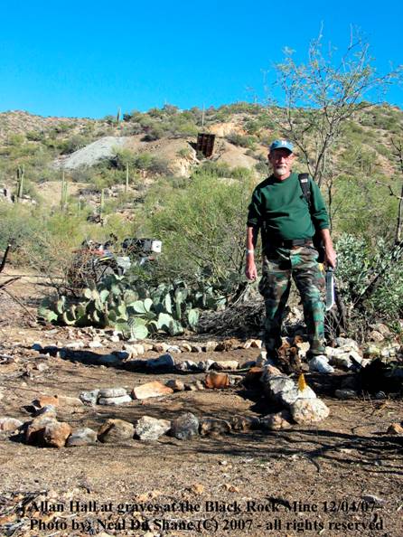
Author standing at one of the Black Rock
Mine Projects
Table of Contents
Click below for
direct connect to subjects:
Figure 1: Main House Terrace and Corral
Figure 2: Small Cemetery on Main
Terrace
Figure 4: Clearing and Survey Work
Figure 5: Flagged Grave Locations
Figure 6: Grave Outlines and Terrace
Wall
Map
of Black Rock Mine Cemetery Locations
Geographic Relationship of Cemeteries:
Black Rock Mine is
one of the most visible features along
After a break from
the summer heat, work has resumed at the Black Rock Mine to complete the
location and documentation of grave sites.
In the spring of 2007 we identified one small cemetery within a rock
walled terrace plus a nearby site that showed evidence of numerous graves over
a much larger area. Figure 1 shows the
multi-tiered terrace that contains the ruins of two buildings and a
corral. To the right of the main terrace
you can see a smaller rock walled rectangle, adjacent to the trail. This is the location of the first cemetery.
Figure 1:
Main House Terrace and
Corral
Although it is
completely derelict it has not suffered from erosion and is in generally good
condition, especially considering that it has been abandoned for at least 65
years. See Figure 2.
Figure 2: Small Cemetery
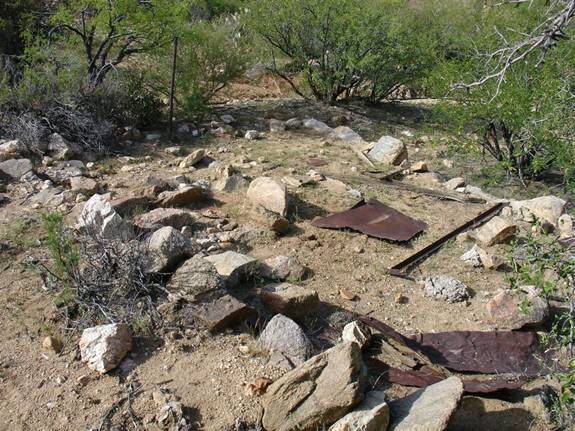
This cemetery
contains seven graves in two rows. The
near side, from left to lower right, has three burials and four are located on
the upper half (also left to right.)
There appear to be
three headstones without inscriptions.
The other graves may have had wood markers at one time, but I have not
been able to locate them. Other than
confirming the presence of the graves, no clearing or marking has been done.
The metal debris
is primarily corrugated roofing material that was probably blown onto the site
from the ruins to the right of this photo.
Otherwise, there is relatively minor disturbance from cattle that graze
in the area. Notice that there is an
iron pipe on the margin of the cemetery near the top of the photo. This is characteristic of graves at Black
Rock Mine; as you will see in the following photos.
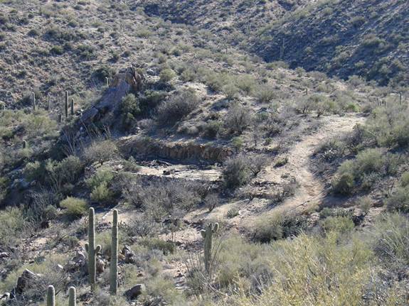
The second
cemetery is on the opposite (west) side of the hill shown in Figure 1. This site was heavily overgrown with acacia,
mesquite, Palo Verde and cactus, making it difficult to determine how the area
was organized until it could be trimmed and cleared. The first physical evidence of graves was
revealed by the presence of metal pipes that had been driven into the ground to
mark grave corners in several locations, but it was still very difficult to see
the “big picture.” See Figure 3.
Figure 3: Grave
Marker Posts
With the return of
cooler weather in November I began trimming the brush and removing old debris
to gain a better view of the cemetery.
What is now evident is a large, double-tiered, rock walled (upper and
lower) terrace that measures approximately 100 feet on the N-S axis by 40 feet
E-W. Selective removal of undergrowth
has greatly improved visibility at the site, as evidenced in Figures 4-5.
Figure 4:
Clearing and Survey Work
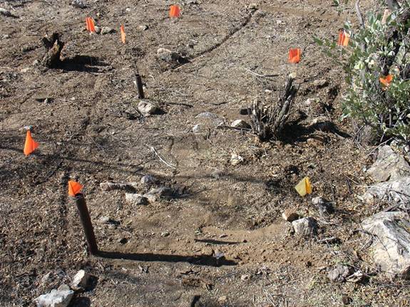
Dead branches and
brush are being removed and, where appropriate, trees have been pruned to make
the graves easier to survey. As seen in
Figure 4 I use survey flags to visually establish individual grave dimensions.
Some fairly large
areas have now been sufficiently cleared to permit easy movement and
preliminary survey work. See Figure 5.
Figure 5: Flagged
Grave Locations
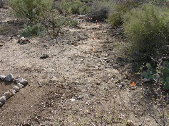
This photo shows
nine flagged graves that are located on the lower of the two terraces at this
site. The trees and cactus on the right
edge are on the western margin of the terrace and additional pruning will be
required before some grave dimensions can be established. We have now identified 31 graves inside the
perimeter of the double terrace. With
the exception of one grave, all are oriented in the traditional east-west
Christian manner. After the survey
effort is fully completed I will assess the number of infant, juvenile and
adult graves.
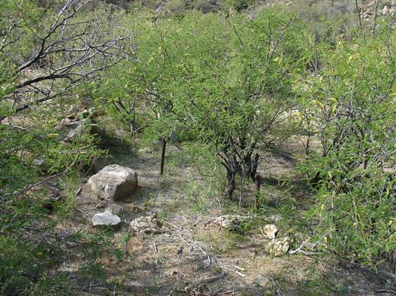
As you can see,
this is still a “work in progress.” I
have only been able to provide rock outlines for six of the thirty-one graves
thus far. See Figure 6.
Figure 6: Grave
Outlines and Terrace Wall
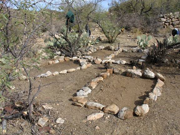
This photo shows
four male graves that are now outlined.
Rocks are by no means a permanent method, especially in areas where
there are livestock; so my process includes driving 10” spikes in each corner,
leaving about one inch above the surface.
When the surveying and marking is completed we will then construct the
APCRP headstones and do the final placements.
Notice also in Figure 6 is a portion of the upper terrace wall which
marks the eastern boundary of this cemetery.
There is one
oddity that we have found thus far and is shown in the photo. The two upper outlined graves may represent
simultaneous burials. Both are juvenile
and there is no measurable separation between the two. It is possible that these two graves were dug
at the same time for siblings.
Site artifacts are
a bit more evident in this cemetery that at the seven graves on the east side
of the hill. We have found the possible
remains of two wood markers. There is
also a partial wood fence structure at the south end of this terrace. Finally, there is a long section of iron pipe
on the northern edge of the cemetery that may have served as a top rail for a
fence.
A Puzzle
The identification
of 38 graves at Black Rock Mine seems to heighten the puzzle about the
“Arrastre” cluster of four cemeteries, located to the west, where there may be
fifty or more additional graves. The
Black Rock was not a particularly successful or long running operation and
could not have employed as many miners as the Monte Cristo Mine, which is a
scant half mile to the south. Excluding
the Monte Cristo Mine, we now have 88 or more graves in very close
proximity. Until we can locate
historical records such a large number of graves is difficult to comprehend.
Location
Information
1.
Drive
east from Wickenburg on
2.
Turn
left and drive down (northwesterly) the creek.
You will encounter a gate that separates grazing leases. This gate has always been closed. In conversations with the rancher, that is
the way it should be left!
3.
Proceed
beyond the gate until you arrive at the bottom of the Black Rock Mine area.
4.
GPS
coordinates for the small cemetery are:
N 34o 04’ 21” by W 112 o 34’ 57”. The location of the large double terraced
cemetery is: N 34 o 04’ 19.8”
by W 112 o 34’ 59.0”. Coordinates
are given as WGS84. See the flagged
waypoints in the map below.
Precautions
1.
This
section of
2.
It is
possible to drive an ATV up to the cemetery area, but be aware that there are
many old nails. It is a short hike from
the creek to the cemeteries.
3.
Do not
enter
4.
At the
point where the trail rises out of
5.
Expect
to see rattlesnakes during the warm season.
There are mine tunnels in this area.
Snakes hibernate in these tunnels during to cold season.
Map of Black Rock Mine Cemetery
Black Rock
and Monte Cristo Mines
Geographic
Relationship of Cemeteries:
In my posting on
the Black Rock Mine above, I stated there are six cemeteries at or near the
mine. Although I referenced the Monte
Cristo Mine in that article, (which is nearly due south of the Black Rock), I
did not mention that two cemeteries have recently been located there as
well. Within an area that is less than
one square mile, we can now account for eight derelict cemeteries of varying
size. The presence of so many cemeteries
in such a geographically small area is surprising – even if some are modest in
size.
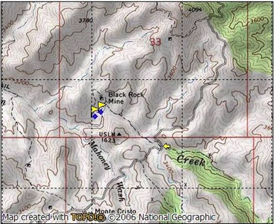
The map image
below shows the vicinity of the Black Rock-Monte Cristo mines and eight
numbered arrows. The tip of each arrow
points to the location of each cemetery.
Map of Cemetery Locations
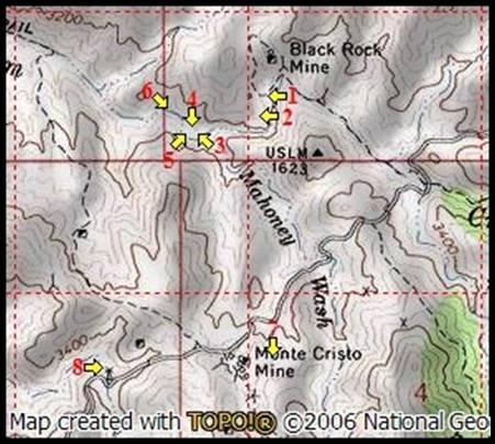
Description
1.
This
is the small, rectangular cemetery on the edge of the main housing terrace at
Black Rock Mine. Seven graves have been
identified but no other work has been performed at this site.
2.
The
double-terraced cemetery at Black Rock Mine.
Thirty-one graves have been identified and extensive clearing and
survey/documentation work is under way.
This cemetery measures approximately 100 by 40 ft. Only six graves have been outlined. Grave corner pins have not been set, but
survey flags are in place to identify all graves.
3.
This
is the Arrastre cemetery that is located a few yards west of the junction of
4.
This
cemetery is located directly above the Arrastre site on a relatively flat point
that rises about twenty feet from
![]() A double burial inside a tent-rock cabin
(male and female adult)
A double burial inside a tent-rock cabin
(male and female adult)
![]() A co-burial of a female and infant
A co-burial of a female and infant
![]() The use of Arrastre floor and grinding
stones at this upper cemetery
The use of Arrastre floor and grinding
stones at this upper cemetery
Otherwise,
the graves in this area are widely dispersed and generally unorganized. There is one remote cluster of four graves
that is too far from the Black Rock Mine to be considered part of either
cemetery #1 or #2. For the time being I
am classifying these graves as members of #4.
Survey work has been underway since March 2007, and will resume when the
two Black Rock Mine cemeteries are completed.
5.
This
is a small cemetery located quite near to the Arrastre. I have identified four graves, but the area is
thick with growth and overhanging branches, and there could be one or two more
burials at this site. Other than the
initial identification of graves, no work has been done. The cemetery is not protected by a rock wall,
as the Arrastre is, and it is closer to the level of
6.
This
cemetery is situated in the least opportune location of all. It is virtually at the level of
7.
The
“Upper” Monte Cristo cemetery was recently discovered by Neal. It is located due east of the head frame,
very near to the northwest corner of the old miners dorm ruin. The initial survey revealed the presence of
approximately eight graves on a hillside.
There is some evidence of rock mounds.
No work has been performed at this site.
The upper cemetery is in very close proximity to an unmarked, open
shaft. Please be careful if you visit
this location!
8.
The
Lower Monte Cristo cemetery is situated on a flat to the west of the mine, at a
point where
Without historical
documentation it is impossible to establish a connection between the cemeteries
#3 - #6 and the mining or settlement activity at Black Rock (#1 and #2) or
Monte Cristo (#7 and #8.) It is possible
(even likely) that both mines may have used these areas.
Most of these
eight cemeteries still require clearing and formal survey work before an
accurate count of graves can be provided.
At present, all we know is that we are dealing with at least 118 graves
and I would not be surprised if we locate even more as the clearing of brush
progresses.
It is well
established that the Black Rock Mine began operation in 1906 and ended in 1941. Unfortunately, it is far from clear when the
Monte Cristo mine began operating. The
year 1909 is well established as the point that Anglo ownership and operation
began, but Mexican nationals may have begun working the veins of horn silver as
early as the 1870’s.
There is little
reason to doubt that at least some of these graves can be attributed to mine
accidents. What is not yet known is the
extent that epidemics or violence may have played to account for the overall
total in this area.
If you love a
mystery, these eight cemeteries are a great place to do historical
research!
EDITORS NOTE: Allan Hall has become the volunteer with the most cemeteries ADOPTED
for Arizona Pioneer & Cemetery Research Project (APCRP).
In addition under his leadership he has numerous cemetery restorations to his
credit along and near
If you or your group would like to ADOPT a Cemetery Project, let APCRP
know and we will assist you in education and training to restore your cemetery
project. It is fun, educational and gets you in the outdoors to enjoy the
beautiful back country of
Internet Presentation
Version 121507
WebMaster: Neal Du Shane
n.j.dushane@apcrp.orgt
Copyright ©2003-2007 Neal Du Shane
All rights reserved. Information contained within this website may be used
for personal family history purposes, but not for financial profit of any kind.
All contents of this website are willed to the
HOME | BOOSTER | CEMETERIES | EDUCATION
| GHOST TOWNS
| HEADSTONE
MINOTTO
| PICTURES
| ROADS
| JACK SWILLING
| TEN DAY TRAMPS