HOME | BOOSTER | CEMETERIES | EDUCATION | GHOST TOWNS | HEADSTONE
MINOTTO | PICTURES | ROADS | JACK SWILLING | TEN DAY TRAMPS
American
Pioneer & Cemetery
Research Project
Internet
Presentation
121310
The “Box Wash” Mine
and “Pipe” Cemetery*
By
Allan Hall
Certified
APCRP Coordinator
The
hunt for old mines, pioneer settlements and grave sites is virtually guaranteed
to produce a surprise now and then. The Arrastre Cemetery, in Slim Jim Creek,
is a well known example. There, many of the graves are marked with discarded
drag stones taken from the arrastre. But - imagine a cemetery where many of the
graves are marked with old ventilation pipes!
Such a place exists south of Wickenburg and can be visited without much difficulty.
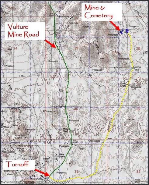
Figure 1 - Mine and cemetery east of Vulture Mine
Road
A
Brief Description of the Mine
Several attempts to establish a
name or date of origin for this mine have proved fruitless, as none of the
standard reference sites has yielded any information. The nearest geographic feature is Box Wash,
which will temporarily serve as a convenient name for the mine. For the moment, at least, it is a hole in
history, as well as the ground.
The mine is located in the NW1/4
of Section 20 in T6N, R5W. This places
it about 2.7 (air) miles northeast of the historic Vulture Mine. GPS coordinates for the shaft are N 33o
51’ 04.08” X W 112o 48’ 23.04” (all coordinates are WGS84).
Several of the mines in this
area (including the Vulture Mine) were discovered or began operation in the
1860s. There are several trash fields in
the vicinity of the mine. The old cans
at these sites include many with solder tops (hole and cap) and Norton’s side
seam construction. This shows the mine
to be in operation at least as early as the late 1880s. The presence of “open top” cans in some dump
piles shows the mine operated until at least 1920, and may have continued into
the 1930s. A thorough survey of these
trash sites is needed to establish a date of operation earlier than 1887.
The mine features one large
shaft with a protective covering and a smaller, irregular, open shaft that may
have been the original mine entrance; later serving as a ventilation shaft. The extent of underground workings is
unknown, but the dump contains several hundred tons of waste material –
sufficient in volume to support a shaft and drifts of several hundred feet. There is no doubt this was a productive mine,
and inclusion of the extracted ore would only increase the size of the
underground workings. (That is, the ore vein would have been removed from the
mine site to a mill for processing. That
volume, plus the waste rock, roughly equals the size of the shafts, drifts and
stopes in the mine.)
Concrete footings next to the
covered shaft suggest a sizable head frame existed at one time, and there are
other concrete works that indicate a large ore hopper was used. There is no evidence that a stamps mill
operated at the mine. Additionally, I
have found no evidence of a well; suggesting that water may have been pumped
from the mine or hauled in from a nearby location. Oddly, no water pipes have been found in the
vicinity of the mine.
Although no buildings remain,
one small, dirt and rock foundation is located on the east side of the trail,
north of the mine shaft and dump. The
presence of bent nails at this location indicates a wood structure that was
probably dismantled after the mine ceased operation. Workers may have lived in tents at the mine
or possibly in Vulture City, about three miles to the SSW.
There are several relatively
shallow open cut prospect trenches within 100 yards of the shaft. This suggests an effort to locate other
portions of the ore vein to the west, northwest and northeast of the main
shaft.
One major curiosity is the
presence of a small arrastre, located about 150 feet south of the shafts. Ordinarily, you would expect this feature to
be associated with gold or silver mines, but the dump appears to contain
material more closely associated with manganese and/or tungsten ore
bodies. That is, the waste material is
uniformly dark gray in color. There is virtually
no quartz gangue, no secondary copper, and only scant traces of oxidized sulfur
on the dump.
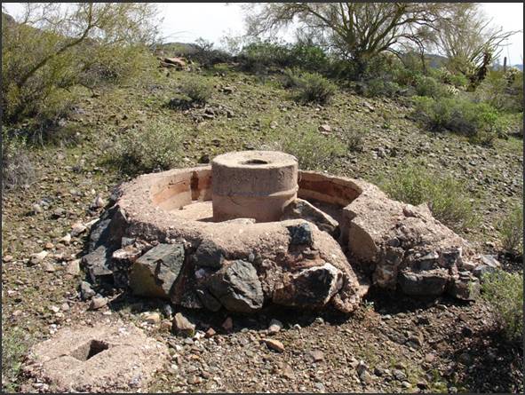
Figure
2, Small arrastre at mine.
The dimensions of this arrastre
are another puzzle – it’s inside diameter measures only 56 inches and the
grinding track is only 17.5 inches wide.
This certainly rules out its use for anything other than pulverizing small
quantities of ore – possibly for assaying.
As Figure 2 shows, the center of the arrastre was built using a metal
drum. Note also the sluice on the near
right side for draining water after the ore charge had been pulverized. I suspect the arrastre may have been a late
addition to the mine, since it was operated mechanically by an electric motor
or gas engine. In any case, the arrastre
does not show signs of long term use.
Grave
Sites at Mine
Thirty-one graves have been
identified at nine sites on or near the mine workings. Of these, twenty-five are contained in three
distinct clusters and six others are appropriately characterized as lone
graves. Only one grave is female. The remaining graves are primarily male
adults, but at least five are juvenile or very young males.
I have taken the liberty of
including photos of all nine sites for the simple reason that they may be
helpful to anyone who is learning how to recognize abandoned graves.
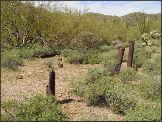
Figure
3, Pipe cluster Site #1
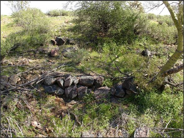
Cluster #1 contains nine male graves
located in two rows on a north-south axis with head positions generally facing east. Seven of these are marked with sections of
pipe at the head position. The pipes
vary in height and may have been used to distinguish adult versus juvenile, as
the small graves are marked only with shorter pipes. This is the northernmost grave cluster and is
approximately 225 feet NNE of the covered shaft. As shown in the photo, the terrain is a
natural flat area above a wash.
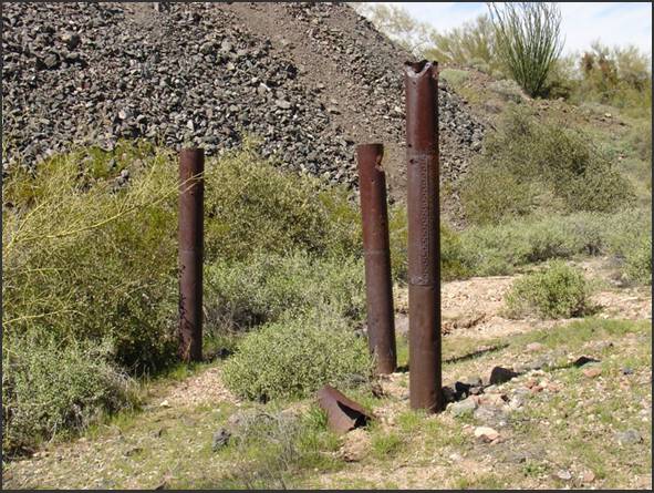
Figure
4, Pipe cluster Site #2
Figure
4 shows part of Cluster #2, which contains seven male graves. Five of the graves are marked with sections
of pipe. This cluster is located on the
east side of the mine, between a portion of the dump and the roadway (out of
view to the right). In contrast to
Cluster #1, the main axis is east-west, but individual graves primarily face
east. The positioning of several graves adjacent to a dump prompts the
question of timing. I suspect these
burials predated the growth (and potential encroachment) of the dump.
Figure
5, Lone male grave at Site #3.
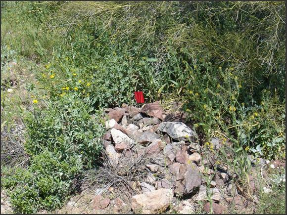
Site #3 contains a single male
adult grave, located on a hillside about five feet above a small wash. The grave has a north-south axis, with the
head facing north. As illustrated in the
photo, care was taken to construct a dry stack retaining wall to prevent
erosion. This grave is located approximately 100 feet south of Site #1.
Figure
6, Pipe cluster at Site #4
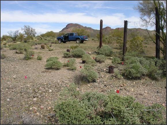
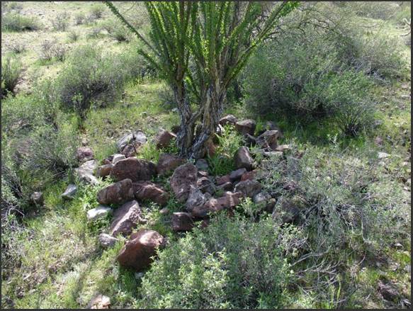
The most unusual pipe cluster is
found at Site #4, where there are nine adult and juvenile male graves in three
rows. The row axis is north-south. The three tall pipes are not grave markers,
however. Instead, they seem to have
served as an entrance to the cemetery from the opposite side. Notice the wire cable suspended across the
tops of the pipes – it may have been adorned with flags, streamers or religious
symbols at one time. In the upper right
corner (right of the tall pipe) you can also see the edge of an ocotillo fence.
Unlike the other two pipe clusters,
this site used only short sections of pipe for grave markers. Why this is so is a mystery. Eight marker flags show the location of
graves. The ninth grave is out of view
to the right.
Certified
APCRP Coordinators Bonnie Helten and Cindy Enos are credited with the initial
discovery and confirmation of these graves.
They visited the site two days after I found the first cluster at Site
#1.
Figure
7, Lone male juvenile grave at Site #5.
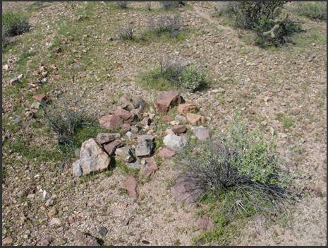
Site
#5 contains a small male, estimated to be not more than three years of
age. Although the grave shows some
disturbance by cattle, it is outlined with rocks and not mounded. Orientation is approximately east-west, with
the head position facing to the east.
Figure
8, Lone Male juvenile grave at Site #6
Site #6 also contains a small
male. Based upon grave size, I estimate its age to be not more than two years. Like
Site #5, this grave appears to have been disturbed by cattle or wildlife, but
was probably mounded rather than outlined. The head position is at the large
boulder at the top. Grave orientation is
east-west.
The young male at Site #5 is
approximately 160 feet southwest of the pipe cluster at Site #4. The male at Site #6 is about 260 feet SSW of
Site #4.
Figure
9, Lone female adult grave at Site #7.
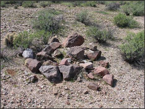
Within
60 feet of Site #6 you will find the only female burial at this mine. It is
distinguished by an impressively large ocotillo growing through the rock mound
that covers the grave. It is also one of the largest mounded graves I have seen,
and it causes me to think this lady was both well known and respected.
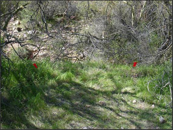
Figure 10, Lone adult male grave at Site
#8.
The lone male grave at Site #8
is approximately 370 feet west of the main shaft and about 100 feet west of the
young male grave at Site #5. This site
is above a wash in a thicket of trees.
There are no markers to aid with visual identification.
A
few feet to the left (south) of this photo there are indications of piled dirt,
suggesting that a tractor or other implement may have leveled or cleared this
spot in preparation for the grave.
Figure
11, Lone adult male grave at Site #9.
Graves can frequently be found along the
margins of old mine and freight trails, as well as stage coach roads. The last of the grave sites is the only one
located on the east side of the trail – literally within a few feet of the
roadway. This is a male with a grave
orientation that is approximately northeast-southwest. Before a full inspection can be completed, branches
must be trimmed from the Palo Verde tree that limits access to it. At present, the dimensions of this grave are
unknown. Kathy Block is credited with
locating it in late March, 2010.
Graves such as this underscore the
oft-repeated premise that (during Territorial days) people were frequently
buried where they died in remote areas.
The thumbnail map below will give you a
visual orientation to the grave sites at the mine. For easy reference, see also the table of
coordinates for each site below.
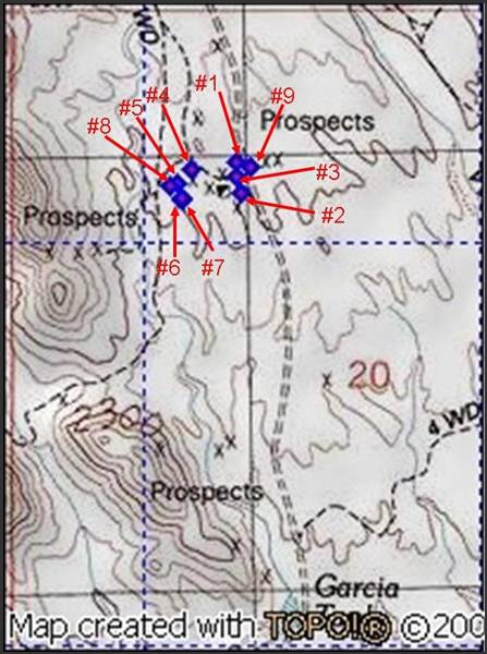
Site Coordinates
|
Arrastre: |
N 33o
51’ 02.64” X W 112o
48’ 23.88” |
|
Pipe cluster site #1: |
N
33o 51' 06.10" X W 112o 48' 21.80" |
|
Pipe cluster site #2: |
N
33o 51' 04.02" X W 112o 48' 21.30" |
|
Lone male grave site #3: |
N
33o 51' 05.00" X W 112o 48' 21.80" |
|
Pipe cluster site #4: |
N 33o
51' 05.58" X W 112o 48' 25.80" |
|
Lone male grave site #5: |
N
33o 51' 04.44" X W 112o 48' 27.12" |
|
Lone male grave site #6: |
N
33o 51' 03.18" X W 112o 48' 26.70" |
|
Lone female grave site #7: |
N
33o 51' 03.36" X W 112o 48' 26.52" |
|
Lone male grave site #8: |
N
33o 51' 04.32" X W 112o 48' 27.72" |
|
Lone male grave site #9: |
N
33o 51' 05.70" X W 112o 48' 20.46" |
Getting
There
1. From
the intersection of West Wickenburg Way (US-60) and Vulture Mine Road, drive
south toward the historic Vulture Mine.
2. After
you pass mile marker 15 you will see the entrance to Vulture Mine approaching
on your right. On your left you will see a dirt road and mail boxes. Turn left
onto the dirt road. This is BLM Trail #9054.
3. Continue
on #9054 until you arrive at a fork in the road. The left fork will be marked
as BLM Trail #9055. Take this trail.
4. Remain
on #9055. Several trails will branch left or right of #9055, but these should
be ignored.
5. You
will pass a large dirt tank (Garcia Tank) on your left as you proceed north.
6. The
mine site is north of the tank on your left. A small two track road will lead
you up onto the dump near the shaft.
7.
Your return from the mine should
retrace the route described above. Trail
#9055 requires 4WD if you attempt to drive north, beyond the mine area.

American
Pioneer & Cemetery
Research Project
Internet
Presentation
121310
WebMaster: Neal
Du Shane
Copyright ©2010 Neal Du
Shane
All rights reserved. Information contained within this
website may be used
for personal family history purposes, but not for financial profit of any kind.
All contents of this website are willed to the American Pioneer & Cemetery
Research Project (APCRP).
HOME | BOOSTER | CEMETERIES | EDUCATION | GHOST TOWNS | HEADSTONE
MINOTTO | PICTURES | ROADS | JACK SWILLING | TEN DAY TRAMPS