Internet
Presentation
Version 030408
Restoring Pioneer
Cemeteries
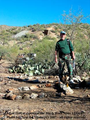
Black Rock Mine, AZ
By:
Allan Hall
Author’s Note:
An abbreviated version of this article first appeared
in the www.wickenburg-az.com web
site on March 1st 2008. The
text and photographic content has been expanded here to more fully address the
restoration efforts and also provide background on nearby cemeteries – some of
which are still being surveyed and documented. - Allan
Introduction
We are surrounded by the
rich history of mining and ranching pioneers who settled and developed the
Mining has always been a
dangerous business, especially in the early days of settlement in
If a prospector’s claim
developed into a working mine, it is a safe bet that you will find a cemetery
on, or very near to, that mine. Such is the
case at the Black Rock Mine where seven cemeteries and a handful of dispersed
graves have been identified in the past year – all previously unknown to our
modern era.
This article focuses on the
efforts to document and restore the largest of these seven sites - a
double-terraced, hillside cemetery containing forty-four organized graves plus
three dispersed burials within fifty yards of the terraces.
A Bit of History
Sam Powell discovered the
Black Rock ore vein in 1902 and the mine began operation in 1906. Operations continued until 1941 when the
federal government shut down many mines due to the onset of World War II. During its thirty-five years of operation,
the Black Rock Mine produced gold, silver and a lesser amount of copper and
zinc ore. Gold values from the pay
streak vein yielded more than $16,000 per ton based upon 2005 prices, so this
would have been an exciting time for the mine operators. You can still walk this area and find rocks
containing chrysacolla lying on the surface, as well as an abundance of
beautiful white and rose quartz.
Unfortunately, the scant historical records indicate that the mine was
not very well managed from the outset of operation until at least the middle
1930’s.
Other well-known mines had
been in operation in the area for two or three decades before the Black Rock
came into being, such as Monte Cristo, Keystone, George Washington, King
Solomon, Abe Lincoln, Bloo Nellie and O’Brien mines, to name only a few. Farther east and north, in the Bradshaw and
Weaver districts, there were hundreds of mines and prospects.
The Black Rock Mine is
located about two-thirds of a mile NNE of the Monte Cristo Mine and is
approximately 1.5 miles downstream of the historic settlement of Constellation
in upper
The settlement of
Constellation had been in existence for a number of years prior to the
discovery of the Black Rock ore vein. It
was an early center of commerce and transportation and figures prominently in
the history and legend of this area. See
Reference 1.
In 1910 the population
surrounding Constellation far exceeded that of Wickenburg. There are estimates that as many as fifteen
to twenty thousand people may have lived in the mining districts east of town
at the height of activity. Although much
of the population was itinerant in nature, the area surrounding Constellation
endured as a significant economic factor until the 1930’s. For example, Constellation had a Post Office
that remained in operation until January 31, 1939. Today, there is nothing more
than a few foundations, two piles of broken glass and a small, isolated
cemetery to mark the passing of this historic site (See note 1).
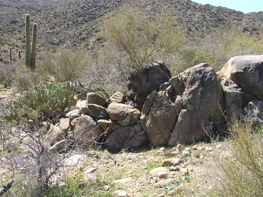
The
One of the distinguishing
characteristics of the Black Rock Mine is its abundance of man-made terraced
walls on the east and west sides of the hill, southwest of the old ore chute
(which still stands). The east side of
the hill, which is nearest to
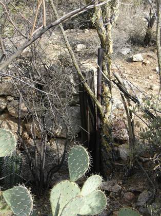
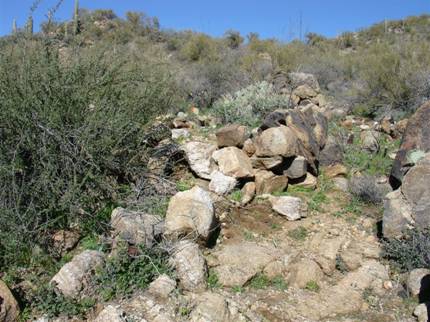
Figure 1 Ocotillo Fence
The eastern side of the hill
shows ample evidence of habitation in the form of collapsed buildings, metal
debris and nails. In fact, The Black Rock
Mine is also distinguished by a relative abundance of wood buildings, both on
the eastern terraces and a few hundred feet to the north. Abandoned mines were often stripped of usable
lumber and carried off to build other structures, sometimes at great distance
from their original location. Thus, the
survival of so many wood structures at this site is a valuable aid to the
historical documentation of the mine (See note 3a and 3b).
The “dry stack” rock terrace
walls are, in some locations, four to five feet in height and are as solid
today as they were when originally constructed.
Much effort must have been invested in creating this well organized
area. In spite of decades of plant
growth on these terraces, the east side of the hill is still quite easy to
inspect on foot.
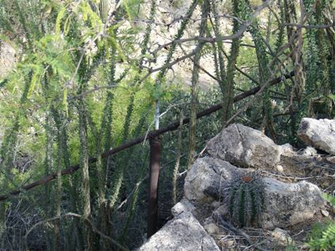
The
In early 2007 when I began
researching the layout of the Black Rock Mine, the western facing side of the
hill was completely overgrown with cactus, mesquite, Palo Verde trees and
native shrubs. There was a single, long
section of old water pipe with thick strands of bailing wire lying on the
northern edge, but, otherwise, the area lacked any of the features that were so
prominent on the eastern hillside.
Inspection of other ruined structures to the north initially led me to
believe (incorrectly) that the pipe was related to a water casement and
windmill about 150 yards away, so I paid little attention to this area until
mid-year. See Figure 2. The only other distinguishing characteristic
was that the area near the pipe seemed to be flat – a decidedly “unnatural”
feature in this terrain.
Repeated trips past this
location raised my curiosity and I began to wonder why the west hillside should
have large flat areas where there were no building ruins.
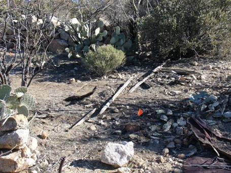
Figure 2 Pipe with Bailing Wire
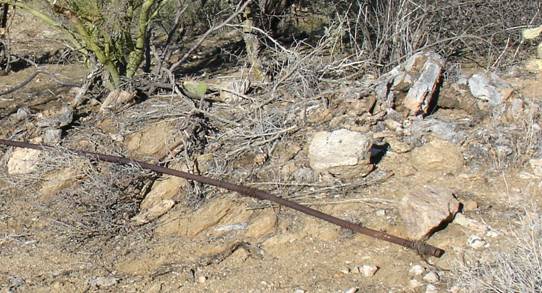
In the May-June period I
began a methodical investigation of the area and did some minor pruning of
shrubs and tree limbs to improve visibility.
These efforts began to expose three important features: low terraced wall structures, old (collapsed)
wood fence posts and rails, and upright metal pipes that had been placed in
rectangular fashion at various locations.
Although there was still no evidence of buildings or metal debris, the
site clearly suggested that it had served a purpose at this mining
settlement. The upright metal pipes were
suggestive of several pioneer cemeteries in the vicinity, leading to the
suspicion that there might be a large grave area along these terraced flats
(See Figure 3).
Figure 3 Metal Pipes

After taking a hiatus from
the heat, survey activity resumed in November of 2007. I began to clear dead brush and prune tree
branches to open the area for an easier survey.
These efforts quickly exposed the presence of an upper, middle and lower
terrace wall that measured 98 feet in length (north-south axis) by
approximately 40 feet. The removal of
low branches revealed eleven upright metal pipes that were closely oriented to
sections of the terraces in a fashion that suggested multiple grave plots of
varying sizes as well as cemetery boundaries (See Figure 4 and 5).
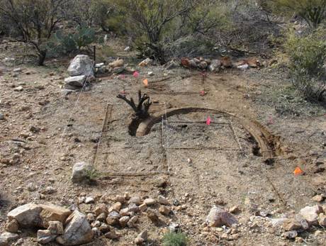
Figure 4 Posts for Two
After clearing one
particularly dense location it become possible to identify two side-by side
grave alignments, as shown in Figure 4.
Each pair of (foreground and upper) posts marked the boundary of a grave
to the right.
The southeast corner of the
cemetery was distinguished by a rock wall, a wood fence post and a pipe. As seen below, the fence post was attached to
the pipe with strands of bailing wire.
Figure 5 Cemetery Corner on Southern Edge
At this point I began
sharing photo documentation with the Arizona Pioneer & Cemetery Research
Project (APCRP) and members of the Arizona Site Steward Program. When APCRP members joined me at the site in
December, we were able to identify a number of grave locations, a few rock
headstones (without inscriptions) and the remains of two possible wood grave
markers that had either collapsed from age or had been trampled by cattle in
past decades. Additional discoveries
included the remains of the fence line and wooden top rail on the southern
margin of the cemetery, as well as old fence posts on the northern margin (See
Figure 6).
Figure 6 Remains of Fence Rail
After clearing a large area
of dead cactus near the fence rail, we made a surprising discovery. On the southern edge of the cemetery there
was a crudely made concrete structure that had become filled with sediment from
the uphill slope. Modest exposure of the
edges revealed it to be oval in shape, but there was so much overlying dirt
that we could not initially determine its true shape, size or function (See
Figure 7).
Figure 7 Oval Structure

Was this an unusual grave
marker, a cistern or a bird bath? Our
initial confusion was compounded by the location to two graves. One appeared to be juvenile in size and was
directly in the center of this structure.
The second grave was located to the south and was partially overlaid by
the oval, as shown in Figure 8.
Figure 8
This view shows the physical
relationship of the oval structure to the two graves. In addition, there is a juvenile grave near
the top of the photo and another in the lower right corner. This curious combination is located on the
southern margin of the lower cemetery terrace.
South is left in the photo.
We now knew we were dealing
with a cemetery that was fairly large.
The terraces were purposely built to provide a sizable area for burials;
indications were that it was well-organized.
Our continued efforts at clearing the space further confirmed that no
buildings had occupied the west side of the hill – there were no ruins, no
nails and virtually no discarded trash.
In fact, the primary trash dump area for the Black Rock Mine was located
to the west of these terraces (See Note 4).
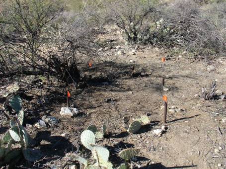
The pace of activity
increased significantly in January 2008 – I was making weekly treks to the site
to complete the clearing effort and establish reliable grave measurements. My survey process included the use of 10 inch
metal spikes that were placed at the corners and head position for each
grave. Figure 9 shows an early stage of
the clearing and surveying work.
Figure 9
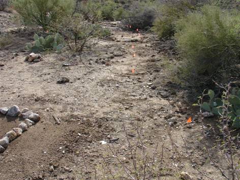
Figure 10, shown below,
illustrates the use of the metal spikes to establish a well defined perimeter
for each grave. This is, admittedly, a
slow process. Nevertheless, it helps
ensure the graves corners can be located years into the future – even if the
rock outlines are moved by cattle or careless visitors.
Figure 10 Corner Pins for Grave Outlines
Note also that I placed an
additional ten inch spike in the center line at the presumed head
position. This will help in future placement
of headstones and also helps to document the orientation of individual graves.
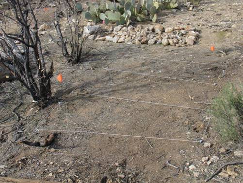
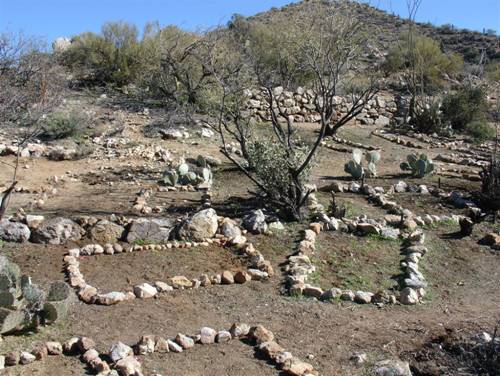
By early February we had
identified forty-four grave sites and were finally ready to restore the
cemetery to a semblance of what it might have looked like before the area was
abandoned. A crew of seven APCRP members
and Arizona Site Stewards trekked to the site to reestablish grave outlines and
finish cleaning the landscape. These activities included restoring the fence
line on the northern margin of the cemetery (the long section of pipe) and
excavation of the concrete oval (See Figure 11).
Figure 11 Fence Rail Restored - North Margin of Cemetery
Sediment in the oval was
removed, revealing a bowl-shaped concrete and metal structure measuring 64 inches
by 58 inches, with a maximum depth of 10” at the center, as if it had been
designed as a small pool or birdbath.
Because its location is directly in line with a series of graves and
appears to overlay two of them, it is possible that the builders of the oval
structure either had no knowledge of the graves, or perhaps had no
concern. See Figure #12.
Figure 12
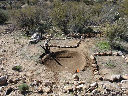
This photo shows the exposed
oval. Partially overlaying the oval on
the left side is the grave outline of an adult burial. We believe there is a juvenile burial
directly below the center of the oval structure, as well.
Rocks were collected from
beyond the margins of the cemetery to aid in the construction of grave
outlines. During this process we
examined additional locations to the west and identified three more
graves. At first glance, grave #45
appears to be a flat space enclosed by rocks and boulders around the perimeter
(See Figure 13).
Figure 13 Grave Number Forty-Five
When viewed from the south
side, however, it becomes evident that considerable effort was invested in
constructing this grave. Building the
perimeter walls involved the movement of some very large rocks. The grave site actually juts out above the
downhill slope with the boulders serving as a retaining wall. See Figure 14.
Figure 14 Grave Number Forty-Five View from South
It is likely that several of
the foreground rocks were originally a part of the wall construction for this
grave.
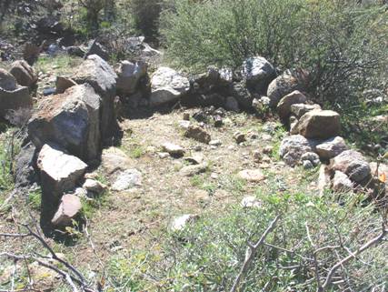
Grave #46 is even more
unusual in that it was constructed in the fashion of a rounded-rock wall that
completely encloses the grave (See Figure 15).
Figure 15 Grave Number Forty-Six

A side view from the right
(north) view shows how this grave was purposely constructed. See Figure 16, below. It is evident that the boulders used in the
construction of this wall do not match and could not be a natural occurrence.
Figure 16 Side View of Grave Number Forty-Six
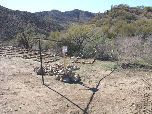
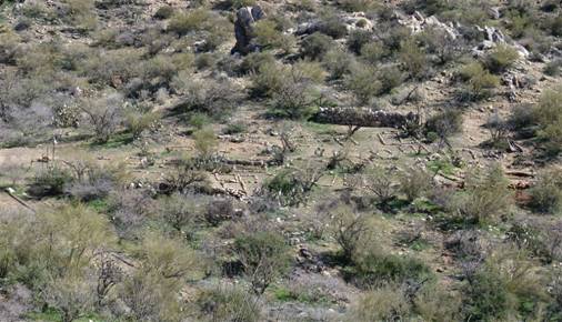
The final restoration effort
of the terraced cemetery area is shown below (See Figure 17). This photo was taken from a hilltop to the
northwest and provides a nice overview of the cemetery and restoration. When viewed from this perspective, it is
easier to understand the overall layout.
As you can see, there is a distinct upper and lower level. It is only when you view the northern (left)
margin of the cemetery from this angle that the two terraces appear to merge.
Figure 17
Physical Condition and Future Prospects
for the West Terraced Cemetery:
As evidenced by the photos,
the cemetery is generally flat on the north-south axis. Because it is located on a hillside, there is
progressive sedimentation from the uphill (east) side that has partially
“reclaimed” the landscaped surface over the decades. Fortunately, the terrace walls remain
reasonably intact and serve to retard (but not entirely prevent) the movement
of soil.
The
physical location of the cemetery is indeed fortunate for it is sufficiently
far removed from any creek or wash so that flooding and erosion are not an
issue. Second, because it was purposely
constructed as a cemetery, the use of dry stack walls has prevented damage to
individual graves. If there is a problem
at all, it would be sedimentation that is slowly, but inexorably, causing the
contour to change shape on the east-west axis (See Note 5).
This is a grazing area for
cattle and there are mule deer and javelina that frequent the site. In fact, the persistent smell of javelina
musk is a distinct reminder that wildlife – not man - is the dominant
visitor. Animal activity (including
cattle) will eventually displace the newly established grave outlines, as had
already occurred between the early 1900’s and the present time. This is a natural and not unexpected
occurrence. With periodic maintenance,
however, there is no reason why this pioneer cemetery should not last for many
more decades.
Observations on the Orientation of
I have yet to find a pioneer
cemetery that was exclusively oriented on the east-west axis. Although it may be customary for Christian
burials to face toward the east, my findings thus far suggest that the
availability of suitable cemetery space (soft earth, not in a flood plain,
shape and contour, etc.) was a dominant factor for grave orientation. Four graves at this cemetery are oriented on
a north-south axis and three of them appear to have a head position at the
north end (i.e.; facing south). After
subtracting the four N-S graves, we are left with 40 that utilized the E-W axis
for burial. Of this group, roughly half
appear to have a head position facing west rather than east.
Grave #45 (west of the
cemetery) also has a North-South orientation, while #46 and #47 face east.
I have no religious or
cultural explanation except to suggest that the people charged with any given
burial had no specific instructions as to how the head placement should
occur. It is equally possible that some
individuals wanted to “face west” for personal reasons.
Based upon the organization
of graves at the seven cemeteries in the vicinity of Black Rock Mine, I believe
that the selection of E-W versus N-S orientation was based upon the
availability of burial space. In other
words, it might be possible to “wedge” a suitable amount of space on the N-S
axis to accommodate a burial. For
example, see the following photo in Figure #18.
Figure 18 Axis of
The grave in the left
foreground has a North-South (left to right) axis and abuts the middle terrace wall,
while all other visible graves have a generally East-West axis.
Relationship To Nearby Cemeteries, Mines
and Settlements
When you consider that this
mine was in operation for not more than thirty-five years, the presence of
seven cemeteries (plus several widely dispersed graves) at Black Rock would
seem to be an unusually high – if not a startling - number. The double-terraced cemetery discussed in
this article has a smaller companion cemetery on the east side of the hill that
contains seven graves. Between these two
sites and the nearby isolated graves, we have identified the resting place of
fifty-four souls. That statistic is not
particularly surprising; it does not stretch rational thinking.
There is another nearby
cemetery that I have only recently discovered.
Although the site is very densely overgrown, I have already identified
fifteen graves, a hand dug well and an arrastre (See note 6). Without further discoveries, this would raise
the grave count to sixty-nine. Those
numbers (three cemeteries and 69 burials) are within the upper limits of
plausibility. It statistically works out
to an average of two burials per year.
The remaining four
cemeteries are located within a fifteen minute walk to the west, but I have
always been puzzled by their location and presumed relationship to Black Rock
Mine – a connection that may very well be the result of insufficient research
by me and a premature rush to form conclusions.
The farther west you travel from Black Rock, the closer you get to the
old trails that lead south to the Monte Cristo Mine.
About 1.5 miles upstream
(from Black Rock) in
It is still too early to
form any firm conclusions about this unusually large cluster of
cemeteries. Plausible explanations
include:
- The cluster of cemeteries west of Black Rock
Mine are related to the early phases of Monte Cristo Mine, before the
original operators were run off by claim jumpers. They would, therefore, likely predate
the three cemeteries that are the closest to Black Rock. Or,
- Several of these cemeteries were used by the
general community in the Black Rock District, including people that lived
in the area around Constellation.
Both explanations make sense
and both could be true – or false. We
simply do not know.
The most recent cemetery
discovery at Black Rock Mine deserves discussion because of its proximity to
the cemeteries on the east and west sides of the terraced hill. This newly found site is on a flat area above
Figure 19 Rock Grave in Cemetery Seven
Unlike the double-terraced
cemetery on the west hillside, Cemetery 7 appears to be more primitive and
lacks the organization that you have observed in other photos. This site also contains the remains of an
old-style arrastre and a hand dug well that tapped the subsurface flow of
At some point in time the
arrastre was dismantled – floor stones and drag rocks were removed and the
circular pit was filled in with dirt.
Only a few of the original outer wall rocks remain in place today and
there are numerous floor stones lying nearby.
Because this site is so
close to Black Rock Mine, I offer five preliminary thoughts:
![]() The arrastre may
have been used to help “prove” the ore content between 1902 (when the vein was
discovered) and 1906 (when mining operations commenced).
The arrastre may
have been used to help “prove” the ore content between 1902 (when the vein was
discovered) and 1906 (when mining operations commenced).
![]() Because Black
Rock never constructed a mill, it is possible that this arrastre was used on a
long term basis. Shipments of ore to
other processing sites might have occurred only when the arrastre was deemed
inefficient for the volume at hand.
Because Black
Rock never constructed a mill, it is possible that this arrastre was used on a
long term basis. Shipments of ore to
other processing sites might have occurred only when the arrastre was deemed
inefficient for the volume at hand.
![]() The graves located
at this site may represent the earliest burials associated with the mine.
The graves located
at this site may represent the earliest burials associated with the mine.
![]() It is too early
to determine if arrastre stones were re-used in the construction of graves in
Cemetery 7. More clearing and survey is
required.
It is too early
to determine if arrastre stones were re-used in the construction of graves in
Cemetery 7. More clearing and survey is
required.
![]() The arrastre to
the west of Black Rock Mine may belong to the early years of the Monte Cristo
Mine, when Mexican nationals were working the vein of horn silver. It seems unlikely that Black Rock Mine would
have utilized the more remote arrastre when this one was close at hand. In fact, I have written several articles
about the first site, known as the “
The arrastre to
the west of Black Rock Mine may belong to the early years of the Monte Cristo
Mine, when Mexican nationals were working the vein of horn silver. It seems unlikely that Black Rock Mine would
have utilized the more remote arrastre when this one was close at hand. In fact, I have written several articles
about the first site, known as the “
It is far too early to draw
firm conclusions about Cemetery 7.
Hopefully, someday, we will locate mine records that will resolve these
questions.
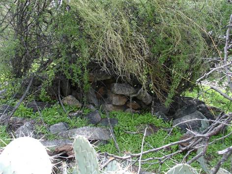
The rock mounded grave shown
in Figure 19 is uncommon in this area and may owe its survival to the density
of brush and trees that have served to protect it from cattle. Graves that are outlined (bordered) with
rocks or that only have headstones are more typically found at these
cemeteries.
Why are the Black Rock Cemeteries
Important?
The Black Rock Mine passed
into history no later than the end of 1941. Even so, it is a visually prominent piece of
our heritage and attracts many viewers from
Most importantly, people
lived, worked and died here. These
cemeteries are the only remaining testament to their struggle to live and
succeed in the
Sadly, the names of people
buried here have passed beyond modern day knowledge or recollection. It is my hope that this article will
eventually connect them with a descendent who knew that a family member once
worked at the Black Rock Mine. This can
provide important clues that aid in historical research of this and other
sites.
As APCRP and Arizona Site
Stewards well know, distant family members are always searching for the
location of an ancestor. Even though we
may never know the names of an individual in any particular grave, the opportunity
to connect descendents with their ancestors is a justified and rewarding
experience.
Although our work to restore
this site has been very conservative in nature, it is, nevertheless, a
conscious and determined effort to preserve our heritage.
How to Get There
1. From the Wickenburg Rodeo Grounds you will drive 11.1
miles on
2. Turn left (downstream) into the creek bed and drive
.4 miles to arrive at the base of the Black Rock Mine.
3. There is a cattle gate in
4. Hike up the granite escarpment on the trail. You will arrive at the terraces after about
100 yards.
Notes:
1. I have a photocopy of a post card that was mailed
from Constellation to
2. There is a second Ocotillo fence northwest of the
housing terrace and corral. Corrals of
this type have also been located in areas near the original route of
3. (a)
4. Long-term occupation at mines produced sizable
quantities of discarded materials, including old cans, broken glass and other
durable trash. There are several “debris
fields” at the Black Rock Mine. My
personal view is that every item that you would ordinarily call “trash” is a
piece of history at this site. Please
preserve it in its present location and condition!
5. I have seen several pioneer graves that were situated
very close to a wash or gulch. In some
instances, periodic flooding has severely eroded the grave margins and caused
the exposure of skeletal remains. The
necessity of quick burial sometimes precluded the wise selection of a durable
grave location.
1. The first arrastre discovered in this area is to the
west on the edge of
2. My deep thanks are extended to the APCRP members and
Site Stewards who contributed their labor to the surveying and restoration of
this historic cemetery.
References:
1.
Crampton, Frank A., “Deep Enough”, pp. 141-151. Published by
Internet
Presentation
Version 030408
WebMaster:
Neal Du Shane
Copyright ©2003-2008 Neal Du Shane
All rights reserved.
Information contained within this website may be used for personal family
history purposes, but not for financial profit of any kind. All contents of this
website are willed to the American Pioneer & Cemetery Research Project (APCRP).