Arizona Pioneer & Cemetery Research Project
2011 Booster
Advantages of a
APCRP Booster
Supporter:
|
1. Name listed on the APCRP web page
as a Booster. 2.
Receive APCRP email staying current with events and research. 3.
Have more fun on field trips than you can shake a stick at. 4.
Gives you a reason to get out of the rocking chair. 5.
Explore Arizona back country History. 6.
10,000+ Abandoned graves have been found and identified. 7.
300+ Derelict/abandoned cemeteries have been documented. 8.
Meet new acquaintances and make lasting friendships. 9.
Meet the nicest and friendliest people in the world in APCRP. 10.
Participate and become part of historical research. 11.
Expand your education and skill levels. 12.
Not-For-Profit organization with 100% Volunteers. 13.
APCRP is not encumbered by Roberts Rules of Order. 14.
Your satisfaction is 100% guaranteed – no questions asked! |
EXCLUSIVE to APCRP: Volume 1 of "Mine Locations in La Paz and Yuma Counties", is currently available through APCRP. If you would like to receive an ELECTRONIC copy by email, you may do so by sending a check for $25.00 plus $5.00 shipping and handling to Neal (see contact information at the end of this document).
APCRP members know that much of the work
we do (research, location, documentation and restoration) places us in contact
with the territorial history of mines, mining camps and settlements. It was the prospect of riches in the gold
fields that attracted most of the early pioneers to this inhospitable and
dangerous land in the mid-1800’s and after, and it is virtually impossible to
develop a full understanding and appreciation of an abandoned pioneer cemetery or
grave cluster without acknowledging the direct or indirect connections between
that site and mine history.
For myself, this recognition prompted me
to do more research into the locations and names of mines in each mountain
range and county in Arizona. I have now completed
the inventory of La Paz and Yuma counties and hope to finish the Yavapai list
in the very near future. Preliminary
work has already commenced on Mohave and Maricopa Counties, and others will
follow as time permits. The first
volume, “La Paz & Yuma County Mine Locations”, contains 1,870 mine workings. Of these, 938 are named mine locations;
including many mines that are either not named on USGS maps or that do not
appear on maps at all. For example, the
three mines shown below are not named by the USGS:
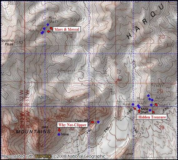
"Unnamed" Mines in the Harquahala Mountains
Not surprisingly, even 1,870 mine
workings is not a complete rendering of the inventory of potential sites. There are several thousand more “prospects”
that failed to demonstrate enough potential to merit further development into
working mines. Unfortunately, there are
many other mines whose names are known, but their locations are now lost. Nevertheless, this compilation represents the
most extensive listing that I have seen in a single document.
Mountain ranges are where you find most
mines in Arizona. This is true because
the uplifting of continental plates and the violent nature of volcanism either
exposed or concentrated the veins of ore in ways that made it relatively easy
to locate. Mountain ranges are far older
than the arbitrary placement of county political boundaries. For example, the Harquahala Mountains stretch
from western Maricopa County into La Paz County, and the Kofa and Trigo
Mountains overlay La Paz and Yuma Counties.
For this reason I have focused my documentation on the mountain ranges. Thus, mines in the western Maricopa portion
of the Harquahalas are included in this listing – even though this volume title
represents La Paz and Yuma. This means
there are 162 named mines and unnamed mine workings in western Maricopa County
that are included.
Most reference documents provide a single
set of GPS coordinates to represent a mine, even though there might be a
half-dozen or more workings (shafts, adits, surface cuts or open pits). This document breaks with that frustrating
tradition and lists the coordinates of every identifiable mine entrance. Rather than place the coordinates “near” the
mine, I have attempted to place them directly at the shaft or adit entrance. The exceptions are those mines that relied
exclusively on open pit operations where the coordinates (waypoints) will be
found at the mine trail entrance to the site.
Otherwise, the only constraint on accuracy is that placed upon a GPS
unit or mapping software. Generally speaking,
every mine opening contained in this list should be within 20 feet of accuracy.
In addition to GPS coordinates, each
entry includes the section, Township and Range for the mine. Why use this anachronistic method? The simplest reason is that Township &
Range are useful in separating one mine from another through historical
documentation – especially where there was a high concentration of activity. Each named mine entry includes a brief
description of the workings and date of origin, if known.
Finally, this document resolves thirty
mines that have “conflicted location descriptions.” Simply stated, the USGS and other reference
sources occasionally got it wrong, and I have made every effort to correct the
location descriptions when these errors were found.
In its current state, the “La Paz and
Yuma County Mine Locations” document is 113 pages in length. When it is (eventually) published in book
form it will include selected photos and maps showing the location of many of
the mines, including those that are not named on USGS maps. It is difficult to estimate the final number
of pages, but it will probably exceed 200.
The published book will also include a means to obtain all GPS
coordinates in a “.gpx” file format for use with National Geographic TOPO or De
Lorme mapping software.
It is my hope this form of documentation
will be useful for your research of historic mines and pioneer sites. As I
expand the coverage to other counties, you can expect the addition of several
thousand more mines. Special thanks to Kathy Block for her help and enthusiasm
during the collection of material for La Paz, Yuma and western Maricopa
counties.
Make Check Payable:
Neal Du Shane
10729 W. Cinnebar Ave.
Sun City, AZ 85351
1-970-227-3512
Arizona Pioneer & Cemetery Research Project